
Jesus’ Baptismal Site to open to the public. According to this Jerusalem Post report, the site where Jesus was baptised will be opened to the public in 10 days’ time, on January 18, 2011.
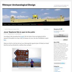
See also Todd Bolen’s report here. When we tried to visit the site last year, following the signs for Qasr el-Yahud, we found that the road was blocked by a military fence and gate. Leen at the road sign for the Baptismal Site Military fence on the road to Bethabara There was a sign which we ignored because we didn’t understand what “photgraphy” was! Get Lost in Jerusalem. Maps - Old Testament Bible Maps by Generation Word. Follow The Rabbi. Galyn's Video of Jerusalem. The True Location of the Red Sea Crossing. Pancratium maritimum - חבצלת החוף. Derivation of the botanical name: Pancratium, pan, "all"; krotion, "power"; means the 'all-powerful,' like Jesus as the Pankrator in Byzantine art.
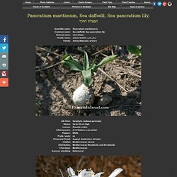
Pantokrator was used to translate the Hebrew title El Shaddai. maritimum, "coastal. " The Hebrew name for the flower is חבצלת החוף (Chavazelet Hachof), and it is also generally accepted, that the Rose of Sharon (shoshan, חבצלת השרון, Chavazelet Hasharon), mentioned in the Song of Solomon (Song of Songs 2:1-2), is identified with the Pancratium maritimum, but without justification. The standard author abbreviation L. is used to indicate Carl Linnaeus (1707 – 1778), a Swedish botanist, physician, and zoologist, the father of modern taxonomy. Pancratium maritimum is a bulbous perennial, growing deeply buried in highly threatened Mediterranean habitats: the sand fields and dunes in the coastal area.
This species became rare because of destruction of the coast by urbanism. Bible resources: Location: Nof Yam coast. Blessing on Mount Gerizim « Israel Tour Guide. The Israel Nature and Parks Authority has just opened the archaeological site on Mount Gerizim in Samaria.
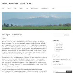
A few years ago we drove up to see the Samaritan Passover sacrifice (quite an experience!) But the site was closed. This is the first opportunity in many years to visit and I can report that it’s definitely worth it. Mount Gerizim is one of two mountains that overlook the West Bank city of Nablus (in Hebrew Shechem, of which there are many Biblical references). Mount Gerizim at 886 meters above sea level (higher than Jerusalem) is one of the highest mountains in Israel. Physical_land. Biblical Backgrounds.com. The Last Israel Travel Guide You'll Ever Need. Landscapes wallpapers - page 113. 3360x1050 Dual Wide 16:10 High Resolution Desktop Wallpapers. WallpapersWide.com Your display featuresAspect Ratio: StandardResolution: 1600 x 1200 Categories.
Maps for every place in the Bible. Encyclopedia ab'-a-na, a-ba'-na ('abhanah (Kethibh, Septuagint, Vulgate)), or AMANA a-ma'-na ('amanah (Qere, Peshitta, Targum); the King James Version Abana (American Standard Revised Version, margin Amana), the Revised Version (British and American) ABANAH (Revised Version, margin Amanah)): Mentioned in 2 Kings 5:12, along with the PHARPAR (which see), as one of the principal rivers of Damascus.
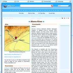
The reading Amana (meaning possibly the "constant," or perennial stream) is on the whole preferable. Both forms of the name may have been in use, as the interchange of an aspirated b (bh = v) and m is not without parallel (compare Evil-merodach = Amilmarduk). The Abanah is identified with the Chrysorrhoas ("golden stream") of the Greeks, the modern Nahr Barada (the "cold"), which rises in the Anti-Lebanon, one of its sources, the Ain Barada, being near the village of Zebedani, and flows in a southerly and then southeasterly direction toward Damascus. C. ORBIS. BibleWalks.com - Holy Land sites review, tours & photos. Timelines - English - A Pictorial explanation of the Bible. Caesarea Philippi, the Gates of Hades. Jerusalem Photo Archive. Bible Geocoding - Bible Maps in Google Earth and Google Maps. The location of every identifiable place mentioned in the Bible.
Complete Bible Google Earth (KMZ) Also available: KMZs arranged by book and by chapter. Turn book or chapter layers on and off to see patterns across the Bible. Individual Books Use Google Earth to open KML and KMZ files. Old Testament New Testament Atlas The atlas lists all the places alphabetically, complete with thumbnails, verses, and photos (when available). Overlays Overlays for Google Earth let you see how maps of ancient and modern Jerusalem fit satellite imagery.
Bodies of Water.