
RU: GDAL - Geospatial Data Abstraction Library. Wxgis - wxGIS is GIS developed using wxWidgets on top of GDAL. The project move to github ( wxGIS is following ArcGIS ideology in developing GIS.
Now wxGIS includes: wxGISCatalog – ArcCatalog analogue. wxGISToolbox – ArcToolbox analogue. The latest standalone version is available for download here The latest portable version is available for download here The package for Ubuntu is available here. Install howto see here The version 0.4.1 of wxGIS main features: New versions of main libs (GDAL 1.9.0, GEOS 3.3.2, Proj 4.8, etc.) Tour at GeoCommons. If you have enjoyed all the data, visualization, and analysis features from GeoCommons, but would like to bring it into your enterprise, then GeoIQ is the product you need.
GeoIQ has all the usability of GeoCommons but hardened and customized for the enterprise. Need bombproof security? Our cloud solutions, Virtual Machines’s and appliances are accredited at the highest levels of national security with features like LDAP, PKI certifications, SSL, and tripwires to name a few. Do you have valuable enterprise databases you would like to provide mapping and analysis on top of? Ideas Submission Portal. OpenStreetMap Globe. Simple 3D Buildings. This page describes tags for basic 3D attributes of buildings.
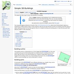
The following tagging methods are results of the 2nd 3D Workshop Garching, where most 3D developers agreed on supporting a unified subset of tags in their programs. Basically we describe the volume of a building using two types of areas. Building outlines for the most general area of a complex building and building parts, to describe esp. parts with different height or other attributes. Building outline Two building:part areas within a building area The building outline is represented as an area tagged with building=*.
Building parts If some parts of the building=* have different attributes (e.g., height), they can be modelled as additional areas, tagged with building:part=yes or building:part=type of building:part. Note that if a building=* contains at least one area tagged as building:part=*, the building outline is no longer considered for volume rendering. Add an additional building:part=yes tag to the building=*. Height Roof. Overpass API. Introduction The Overpass API (formerly known as OSM Server Side Scripting, or OSM3S before 2011) is a read-only API that serves up custom selected parts of the OSM map data.
It acts as a database over the web: the client sends a query to the API and gets back the data set that corresponds to the query. Unlike the main API, which is optimized for editing, Overpass API is optimized for data consumers that need a few elements within a glimpse or up to roughly 100 million elements in some minutes, both selected by search criteria like e.g. location, type of objects, tag properties, proximity, or combinations of them. It acts as a database backend for various services. Overpass API has a powerful query language with a lot more features than the former XAPI based tools. To support small and well scaling OSM main services, Overpass API is run as a third party service. Queries to the Overpass API are in XML or Overpass QL form.
Overpass API also provides permanent links. Limitations. Geocode Dataflow Walkthrough. The following steps show how to use the Geocode Dataflow API and version 2.0 of the Geocode Dataflow data schema to geocode large sets of spatial data.
Uploading Your Spatial Data Format the data To create a job to geocode a set of spatial data using version 2.0 of the Geocode Dataflow schema, your input data must conform to the Geocode Dataflow Data Schema - Version 2.0 and be specified using XML format, or as text strings delimited by the comma, tab, or pipe (|) character.
The following is an XML example that contains data to geocode. You can find examples in other formats in Geocode Dataflow Sample Input and Output Data Version 2.0. Upload the data and create the geocode job To geocode the data, upload the data and create a geocode job by using a REST URL and HTTP POST protocol. When you make this request, the response includes a DataflowJob resource. <Response xmlns:xsi=" xmlns:xsd=" xmlns=" © 2010 Microsoft and its suppliers. Home - Bing Maps Account Center.