
4dSomme. The relatively low rolling chalk landscape of the Somme region was suited well to the development and technologies of WW1 trench warfare.

Large open field systems and scattered woodlands allowed the construction of long lines of interconnected defensive trench systems, while the woodland and forest gave cover to command and artillery positions. Many of the British soldiers saw their first fighting at the Battle of the Somme. They were part of a volunteer army called Kitchener's Army, recruited by the Minister of War, Lord Kitchener. Men who joined up were grouped together in infantry battalions. These units were called ‘Pal's battalions’ because the volunteers were guaranteed to be placed with the friends and neighbours they joined up with.
During the war, three infantry divisions were raised from men across Ireland and were numbered the 10th, 16th and 36th Divisions. [Interact with the 3d Map to Explore the region] 60 Years of Urban Change. A Land Beyond the Stars. À votre service, Monseigneur ! Abandoned Berlin. ACS Commute Map. Alpen. Are maritime law enforcement forces destabilizing Asia? Importantly, the use of CCG vessels to ensure China’s maritime interests is not isolated to the South China Sea.
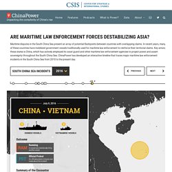
In the East China Sea, China conducts regular patrols with both CCG ships and other law enforcement vessels in the territorial sea and contiguous zone around the disputed Senkaku/Diaoyu Islands. Conflicting territorial claims between China and Japan has resulted in a number of incidents. The most prominent incident occurred on September 7, 2010 when a collision between a Chinese fishing trawler and Japanese Coast Guard patrol boats resulted in the arrest of the Chinese fishing captain. The incident triggered a major diplomatic row between China and Japan. According to the Japan Coast Guard, Chinese incursions into contested waters in the East China Sea have trended upwards since 2010 and have become routine since September 2012, following the Japanese government’s purchase of three of the Senkaku/Diaoyu islands from a private Japanese citizen.
Battles. BatiParis : période de construction des immeubles parisiens. Ben's Guide to th US Government. Berlin 1928 und heute. Big, Allied and Dangerous (BAAD) Skip to main content Big, Allied and Dangerous (BAAD) The Big, Allied and Dangerous (BAAD) online platform features updated, vetted and sourced narratives, and relationship information and social network data on 50 of the most notorious terrorist organizations in the world since 1998, with additional network information on more than 100 organizations.

Funded through the Department of Homeland Security’s Science and Technology Directorate’s Office of University Programs, the underlying BAAD database was created and is maintained by the Project on Violent Conflict at the University at Albany’s Rockefeller College of Public Affairs and Policy. Blast Map. Block by Block, Brooklyn’s Past and Present. On my weekly walk to get groceries, I pass a row of brownstones — some well-kempt and majestic, some fossil-like and crumbling — bookended by a gleaming, square-windowed silver tower.

It’s an architectural contrast of a kind that’s commonplace throughout Brooklyn. The borough’s a patchwork of the old and new, but traces of its history aren’t spread evenly. Boom to Bust. Boston Coastlines. Coastlines of Boston I used the Mapbox Studio dataset editor to trace Boston's coastlines from 1788 and 1898.

See how Boston has grown over the centuries! Overview center. Canadian Hydropower Interactive Map. Carta Històrica de Barcelona. Carte des pentes. Chinese Aid in the Pacific. Chronas. Chronicling America. CIA Cartography. Cité romaine. Claude Shannon : Le monde en binaire. COLLAGE - The London Picture Archive. Comment s'est faite la France ?
Ce module pédagogique permet de découvrir le Moyen-âge et la constitution du royaume de France.

Il propose la reconstitution d'une chronologie historique de la préhistoire à nos jours ainsi qu'une grille de mots qui permettra de trouver le nom d'un des rois fondateurs de la France. D'autres jeux vous proposeront des explications sur la cérémonie du sacre, les implications de la succession de Charlemagne sur la création de la France et d'une partie de l'Europe et enfin comment Paris est devenue une vraie et grande capitale après less travaux menés par Philippe Auguste ... Connectivity Atlas. CyArk Projects. Cyclodeo. D-maps. Dans l'enfer de Verdun. Dark Map of European Infrastructure. Declassified US Nuclear Targets. Even though today’s nuclear targets list is classified, it probably doesn’t look dramatically different.

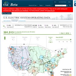
The United States still has about 1,900 nuclear warheads deployed on missiles and bombers (with thousands more on reserve), ready to be launched at a moment’s notice and able to hit their targets within 30 minutes. This unstable situation is extremely risky and has repeatedly come close to triggering nuclear war by accident. Deep Sea Mining Watch. Discovering Britain. Dissocier les capitales et pays de l'Union européenne. Dublinia. Earth Obs Composites. Electric System Operating Data. U.S. electricity demand (Lower 48 states)megawatthours Oct 1, 2016 AC-DC-AC tie Data temporarilywithheld* Generation only,no demand.
Euchronie. Explore the world with Tim Peake. Exploring the Vilnius Ghetto. Exploring the world of Connectography. FlightAware. Flightradar24. Ford's Theatre. Foreign Aid Trends. GameOn.World. Géo mystère. Géographie, trouve une ville : jeu pour enfant. GeoGuessr. Geopedia. Geoquiz! Globa Diplomacy Index. Global Oil Imports & Exports Map. Global Surface Water Explorer. Google Cultural Institute. Google Timelapse. Great Tokyo Air Raid.
Gulag Online virtual museum. Here's Everyone Who's Immigrated to the U.S. Since 1820. From 1820 to 2013, 79 million people obtained lawful permanent resident status in the United States.

The interactive map below visualizes all of them based on their prior country of residence. The brightness of a country corresponds to its total migration to the U.S. at the given time. Use the controls at the bottom to stop / resume the animation or to move back and forth in time. Hiroshima Archive. Historic London by Expedia UK. Historic Place. Historypin. Icelandic Saga Map. If It Were My Home. iGoCam - Map. Inside Asia Tours - Burma. Inside Asia Tours - Japan. Inside Asia Tours - Vietnam, Cambodia & Laos.
JeuxGéo. Jewish Survivors Of The Holocaust. Jewish Warsaw. L'empire de Charlemagne - jeu de devinettes. Les derniers rois mérovingiens perdent leur pouvoir.

Ils laissent peu à peu le pouvoir au maire du Palais. Charles Martel, un des maires du Palais, réorganise le royaume en remportant de nombreuses batailles. Il est notamment célèbre pour avoir arrêté les arabes à Poitiers en 732. Son fil, Pépin le Bref, va renverser le dernier roi mérovingien, Childéric III et se fait sacrer roi en 751. C'est le début de la dynastie des carolingiens. Le fil de Pépin le Bref, Charlemagne, lui succède en 768. La naissance du Royaume de France de Clovis à Charlemagne - Jeu de bouche-trous. Land Lines. Le débarquement de Normandie : du D-Day à la libération de Paris. Le Grand Atlas.
Les 68 stations de métro de Montréal vues autrement. Les différentes périodes historiques : Préhistoire, Antiquité, Moyen Âge. Les fusillés 1940 - 1944. Les océans, mers, fleuves et continents. Locating London's Past. M&S Supplier Map. Mapillary. Mapped: How Germany generates its electricity. ENERGY | September 20. 2016. 7:00 Mapped: How Germany generates its electricity Germany’s “Energiewende”, which translates as energy transition, conjures up images of bright, sunlit fields scattered with wind turbines and solar panels. Mapped: The world's nuclear power plants. NUCLEAR | March 8. 2016. 17:19 Mapped: The world’s nuclear power plants From the latest crisis over plans for Hinkley Point in the UK, to Friday’s fifth anniversary of the Fukushima disaster, nuclear power plants are currently much in the news. To help provide a global overview of the nuclear power sector both today and throughout its history, Carbon Brief has produced this interactive map.
It shows the location, operating status and generating capacity of all 667 reactors that have been built, or are under construction, around the world, ever since Russia’s tiny Obninsk plant became the first to supply power to the grid in 1954. Mapping 24 Hours of Traffic Across the U.S. Highway System. Highway networks are often compared to the human circulatory system, an analogy that works on many levels.
The hierarchical structure of highways, streets, and local roads matches that of our body’s arteries, veins, arterioles, venules, and capillaries. And like the circulatory system, highways serve as the infrastructure by which resources are distributed to where they are needed, keeping the system healthy and helping it to grow. The analogy also works visually, as demonstrated by the map below. Marine Traffic. Mean Centers of Population: 1790 to 2010.
Méli-Mélo des reines et rois de France. Les reines et rois de France se sont perdus dans le temps. Il faut les resituer dans la bonne chronologie. Mémoires en jeu. Memory des grands personnages de l'histoire de France. Milestone Map of Rome. Monte-Carlo Virtual Tour. Multicultikaart. Nagasaki Archive.