
Extreme Ice Survey. Climate Change, Deforestation, Biomes and Ocean Currents, Plankton, Endangered Species - Earth Web Site. Click for more detail Thermohaline Change Evidence is growing that the thermohaline current may be slowed or stopped by cold fresh water inputs to the Arctic and North Atlantic oceans.

This could occur if global warming is sufficient to cause large scale melting of arctic sea ice and the Greenland ice sheet. Such a change in the current may be gradual (over centuries) or very rapid (over a few years). Either would cause planet wide changes in climate. This effect may be part of what starts and stops the ice ages. "Diatoms (a kind of phytoplankton) are estimated to "scrub" roughly as much CO2 from the atmosphere each year as all the world's rainforests. "Net primary productivity is the mass of plant material produced each year on land and in the oceans by photosynthesis using energy from sunlight. Biodiversity is the variety of life found at all levels of biological organization, ranging from individuals and populations to species, communities and ecosystems. Click for more detail. Antarctic Ice. Sea Level Rise Explorer - Global Warming Art. From Global Warming Art Elevation Relative to Sea Level (m) Description The map shown above allows you to explore the regions of the Earth that are most vulnerable to sea level rise.
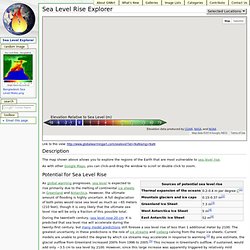
As with other Google Maps, you can click-and-drag the window to scroll or double click to zoom. Potential for Sea Level Rise As global warming progresses, sea level is expected to rise primarily due to the melting of continental ice sheets in Greenland and Antarctica. During the twentieth century, sea level rose 20 cm. However, even if global temperatures stabilize in 2100, the full magnitude of sea level rise is expected to take far longer to develop.
Accuracy of Maps The sea level data appearing in my maps is based primarily on version 2 of NASA's Shuttle Radar Topography Mission (SRTM), with post-processing by CGIAR to fill-in voids using data from other sources. The SRTM data are limited to a region of 60 S to 60 N latitude. Related Materials References ^ [abstract] [DOI] Knutti, Reto and Thomas F. Ozone hole discoverer's warning. British scientists discovered the ozone hole over Antarctica in 1985 The leader of the team which found the hole in the earth's protective ozone layer has urged world leaders to do more to safeguard the environment.
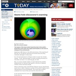
Speaking to BBC News on the 25th anniversary of the reporting of the hole, Dr Joe Farman said the environment was still being recklessly damaged in many ways. He criticised politicians for failing to lead on issues like climate change - it was "damned stupid" to keep increasing emissions of CO2 when we know it is a warming gas, he said. But, in a nod to climate sceptics, he also blamed the scientific establishment for failing to take specific criticisms of detailed climate science seriously enough. When Dr Farman's team at the British Antarctic Survey reported the ozone hole in 1985, it became a symbol of the earth's fragility and a rallying point for environmentalists.
We do not need complex computer models to tell us we need to cut CO2 emissions, he says.