
Maps - National Geographic. Early world maps. Antiquity Babylonian Imago Mundi (c. 600 BCE) A Babylonian world map, known as the Imago Mundi, is commonly dated to the 6th century BCE.[1][2] The map as reconstructed by Eckhard Unger shows Babylon on the Euphrates, surrounded by a circular landmass showing Assyria, Urartu (Armenia)[3] and several cities, in turn surrounded by a "bitter river" (Oceanus), with seven islands arranged around it so as to form a seven-pointed star.
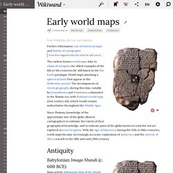
The accompanying text mentions seven outer regions beyond the encircling ocean. The descriptions of five of them have survived:[4] the third island is where "the winged bird ends not his flight," i.e., cannot reach.on the fourth island "the light is brighter than that of sunset or stars": it lay in the northwest, and after sunset in summer was practically in semi-obscurity.The fifth island, due north, lay in complete darkness, a land "where one sees nothing," and "the sun is not visible. " Anaximander (c. 610 – 546 BCE) WhatWasThere - Put history in its place! Historypin. History of Cartography: Volumes One, Two, and Three. The Historical Evolution of Europe's Borders.
Caricature Map of Europe 1914. The Clanker Powers: Germany is a massive military machine with weapons aimed outwards to all surrounding countries.
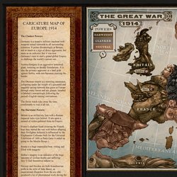
It points threateningly at Britain, not so much as a sign of direct aggression, but more as an indicator that it was now Germany’s turn to start a grand global Empire to challenge the world’s current one. Austria Hungary is an aggressive armoured giant, teetering on shoddy foundations. It is also the primary aggressor in a land grab against Serbia, with two bayonets piercing the border. The Ottoman empire is a teetering automaton, collapsing under the weight of a paranoid and ungainly spying network that gazes at Europe through many lenses and spy glasses. The Swiss watch ticks away the time, comfortable to wait it all out. The Darwinist Powers: Britain is an militaristic lion with a Roman Imperial italic-type helmet. Russia is a huge imperialist bear, rotting and filled with maggots. Portugal is a parrot for the Entente trying to goad a slumbering Spain into the war. The map as history : a multimedia atlas of world history with animated historical maps.
World Map 3500 BC. AncientEgyptMap.jpg (JPEG Image, 841x1474 pixels) Visual History of War, Religion, and Government. It’s a Google Streetmap of history: How our famous landmarks looked up to 170 years ago. By Daily Mail Reporter Updated: 07:19 GMT, 7 November 2011 A website has taken the notion of the 'Now and Then' photo to another level with their 'Google Streetmap of history' which allows people to see what a British street looked like 10, 20 or even 100 years ago.

Like a photographic trip down memory lane, the phone app allows users to 'pin' photos to places on the map meaning you can see how the world has changed since the photo was taken, and read the stories behind the area. A vibrant Cambridge Market in the 1900's and today with several marquees in place It means people can see how the likes of London's Oxford Street and Wembley stadium, Cambridge city centre, or even Brighton pier, have developed over the past 170 years - just as it would appear on Google Streetmap. Historypin was founded by Oxford graduate and former teacher Nick Stanhope, CEO of London-based 'We Are What We Do', a non-profit company created in 2010. 'Everyone has history to share.
United States Historical Maps. Historical Maps of the United States Historical Maps of U.S.

CitiesHistorical Maps of TexasHistorical Maps of Texas CitiesMaps of National Historic Parks, Memorials, Military Parks and BattlefieldsNational Atlas of the United States of America (1970)Pre-1945 Topographic Maps of the United StatesU.S. Historical Maps on Other Web Sites Early Inhabitants (From The National Atlas of the United States of America (Arch C. Gerlach, editor). Early Indian Tribes, Culture Areas, and Linguistic Stocks - Eastern U.S. (632K) Early Indian Tribes, Culture Areas, and Linguistic Stocks - Western U.S. (639K) Early Indian Tribes, Culture Areas, and Linguistic Stocks - Alaska (942K) Exploration and Settlement (Except as noted, from The National Atlas of the United States of America (Arch C.
Exploration and Settlement Before 1675 (1.13MB) The Coronado Expedition 1540-1542 (135K) U.S. From American Military History, United States Army Center of Military History, 1989 (194K) Lewis and Clark Expedition 1804-1806. TimeMaps - World History Atlas.