
Adaptive_urban_development_rutger_de_graaf.pdf. Marine Protected Areas. Aquatic Dead Zones. The size and number of marine dead zones—areas where the deep water is so low in dissolved oxygen that sea creatures can’t survive—have grown explosively in the past half-century.
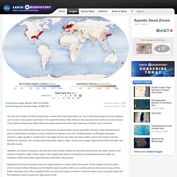
Red circles on this map show the location and size of many of our planet’s dead zones. Black dots show where dead zones have been observed, but their size is unknown. It’s no coincidence that dead zones occur downriver of places where human population density is high (darkest brown). Some of the fertilizer we apply to crops is washed into streams and rivers. Fertilizer-laden runoff triggers explosive planktonic algae growth in coastal areas. Satellites can observe changes in the way the ocean surface reflects and absorbs sunlight when the water holds a lot of particles of organic matter.
Naturally occurring low-oxygen zones are regular features in some parts of the ocean. ReferencesDiaz, R. Instrument(s): Aqua - MODIS. Ocean Dead Zones. NEEACInfo_Guide_ENG.pdf (Objet application/pdf) Ramsar Classification System for Wetland Type. The Ramsar Classification System for Wetland Type is a wetland classification developed within the Ramsar Convention on Wetlands intended as a means for fast identification of the main types of wetlands for the purposes of the Convention.[1] List[edit] Marine/coastal wetlands[edit] Inland wetlands[edit] Human-made wetlands[edit] (1) - Aquaculture ponds(2) - Ponds (farm and stock ponds, small stock tanks, or area less than 8 ha)(3)(4)(5)(6)(7)(8)(9)(Zk(c)) - human-made karst and other subterranean hydrological systems.
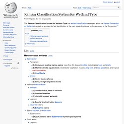
Wetland. Marshes develop along the edges of rivers and lakes.
Many species of frogs live in wetlands, while others visit them each year to lay eggs. Snapping turtles are one of the many kinds of turtles found in wetlands The UN Millennium Ecosystem Assessment determined that environmental degradation is more prominent within wetland systems than any other ecosystem on Earth. [citation needed] International conservation efforts are being used in conjunction with the development of rapid assessment tools to inform people about wetland issues.
[citation needed] Constructed wetlands are used as a water management tool and may play a role in the developing field of water-sensitive urban design. Riparian zone. A well-preserved riparian strip on a tributary to Lake Erie Characteristics[edit] Riparian zones may be natural or engineered for soil stabilization or restoration.
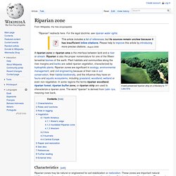
These zones are important natural biofilters, protecting aquatic environments from excessive sedimentation, polluted surface runoff and erosion. They supply shelter and food for many aquatic animals and shade that is an important part of stream temperature regulation. When riparian zones are damaged by construction, agriculture or silviculture, biological restoration can take place, usually by human intervention in erosion control and revegetation. Roles and functions[edit] Riparian zones dissipate stream energy. Bog. Carnivorous plants, such as this Sarracenia purpurea pitcher plant of the eastern seaboard of North America, are often found in bogs.
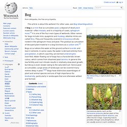
Capturing insects provides nitrogen and phosphorus, which are usually scarce in such conditions. A bog is a mire that accumulates peat, a deposit of dead plant material—often mosses, and in a majority of cases, sphagnum moss.[1] It is one of the four main types of wetlands. Other names for bogs include mire, quagmire and muskeg; alkaline mires are called fens. They are frequently covered in ericaceous shrubs rooted in the sphagnum moss and peat.
The gradual accumulation of decayed plant material in a bog functions as a carbon sink.[2] Distribution and extent[edit] Bogs are widely distributed in cold, temperate climes, mostly in boreal ecosystems in the northern hemisphere. Floodplain. Paraná River Floodplain, at its confluence with the Verde River, Brazil.
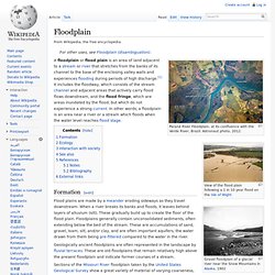
Astronaut photo, 2012. View of the flood plain following a 1 in 10 year flood on the Isle of Wight Gravel floodplain of a glacial river near the Snow Mountains in Alaska, 1902 Formation[edit] Flood plains are made by a meander eroding sideways as they travel downstream. Geologically ancient floodplains are often represented in the landscape by fluvial terraces. Sections of the Missouri River floodplain taken by the United States Geological Survey show a great variety of material of varying coarseness, the stream bed having been scoured at one place and filled at another by currents and floods of varying swiftness, so that sometimes the deposits are of coarse gravel, sometimes of fine sand or of fine silt. The floodplain is the natural place for a river to dissipate its energy. Ecology [edit] Floodplains can support particularly rich ecosystems, both in quantity and diversity. Lands of the Lake - Chapter 1/7: Mekong Fisheries.