
Visualization: Geochart - Google Chart Tools. Overview A geochart is a map of a country, a continent, or a region with two modes: The region mode colorizes whole regions, such as countries, provinces, or states.
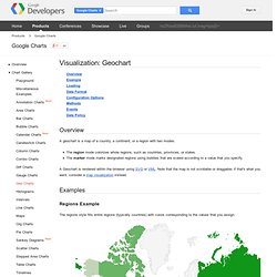
The marker mode marks designated regions using bubbles that are scaled according to a value that you specify. A Geochart is rendered within the browser using SVG or VML. Note that the map is not scrollable or draggable; if that's what you want, consider a map visualization instead. Examples Regions Example The regions style fills entire regions (typically countries) with colors corresponding to the values that you assign. function drawRegionsMap() { var data = google.visualization.arrayToDataTable([ ['Country', 'Popularity'], ['Germany', 200], ['United States', 300], ['Brazil', 400], ['Canada', 500], ['France', 600], ['RU', 700] ]); var options = {}; Markers Example A marker style map renders bubble-shaped markers at specified locations with the color and size that you specify.
Displaying Proportional Markers Loading Data Format Events. Google Maps Icons, Map Markers, Free POI Icons, GIS Symbols. Ligne curvee entre 2 points. Edit this Fiddle. Google Maps V3 - Google Web Toolkit Examples & Demos. Jquery-ui-map - Google map v3 plugin for jQuery and jQuery Mobile.
The Google Map version 3 plugin for jQuery and jQM takes away some of the head aches from working with the Google Map API.
Instead of having to use Google event listeners for simple events like click, you can use jQuery click events on the map and markers. It is also very flexible, highly customizable, lightweight (3.2kB or 3.9kB for the full) and works out of the box with jQuery mobile. But one of its best features (atleast for SEO people) is that you can populate a map from microformats, RDFa or microdata on your site, which can be used as a fallback when a user doesn't have javascript enabled. Download the plugin with examples or get the minified file here Donate Entities which have donated jQuery mobile demo jQuery Mobile example Demo Documentation Tutorial sample code.
Demos and tutorials using jquery-ui-map Help? Post in the forum If you need professional help with any implementation please email me directly Links. Demo Google Maps V3. jQuery + Google Maps API v3 Demo. Google Map API V3 : Placer un marker sur la carte - Code-Web.org. L'objectif de ce billet est de créer une carte Google Map sur laquelle nous localiserons un cinéma Pathé. Nous placerons à cette endroit un logo Pathé à la place de l'image classique des Marker Google Map.
Enfin nous adjoindrons une fenêtre d'informations à ce Marker qui proposera de se rendre sur le site officiel du cinéma. Placer un Marker Nous allons utiliser l'objet Marker de l'API Google Map. Son constructeur prend un seul paramètre, un tableau statique d'options : position définit la position du Marker sur la carte et prend un objet de type LatLng.map définit la carte sur laquelle afficher le Marker et prend donc un objet de type Map.title définit le texte qui sera affiché au survol de la souris et prend une chaîne de caractères classique.
Vous pouvez observer le rendu de ce premier exemple. Personnaliser l'icône du Marker Nous allons maintenant remplacer l'image classique des Marker Google Map par une image de notre choix. Vous pouvez observer le rendu de ce deuxième exemple. Using KML for Thematic Mapping. Earth Outreach. Google Earth allows you to put your content into a geospatial context.
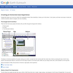
More importantly, it allows you to tell stories. In this tutorial, you'll learn some ways to make your content accessible, easier to navigate, and more compelling. The Google Earth Interface There are three main ways people will interact with your KML through the Google Earth interface: Places panel 3D map Your description balloons To design an immersive experience for people viewing your content, consider the most common path that visitors take. Here are examples of KMLs that provide an immersive, high-quality visitor experience: Make a Good First Impression The first thing most people see when they open a KML or KMZ file are the icons, models, image overlays, and polygons in the 3D view of Google Earth.
Take Snapshots of your placemarks. Setting a good default view for your placemarks and folders is one of the most important things you can do to ensure a good user experience. Don't overwhelm visitors. Use custom icons. TAGS. Untitled. Fonds des Affections Respiratoires - Carte interactive des CAF en Wallonie. jQuery gMap 2 - Google Maps API V3. gMap is a jQuery plugin that helps you embed Google Maps into your website.
With less than 2 KB (minified and gzipped) in size it is very flexible and highly customizable Original version by Cedric Kasner, modified by Mario Estrada to use the Google Maps API V3. gMap 2.1.5 (includes source code and minified version) Contribute Fork it on GitHub and submit bug reports and pull requests. Default View Code: $('#map').gMap(); Custom Controls and Map Type* * This map will show your current location if your browser supports the Geolocation API and you allow it to run.