
Google Code Playground. Google Maps polylines code generator. Costum icon marker google directions. Start: End: Description If you want to change icons of direction result, go through these below steps: (1) set "suppressMarkers : true" to the DirectionsRenderer. (2) and then receive a result of direction, pick up the steps from result. (3) After that, put the markers as direction marker by yourself.
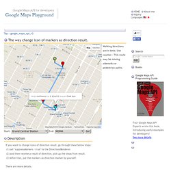
There are more details. (1)Suppress markers When you show the direction result, you usually use DirectionsRenderer. As a result, DirectionsRenderer shows only lines. (2)Pick up steps from DirectionsResult DirectionsResult passes to a callback of as the first argument. DirectionsService.route(request:DirectionsRequest, callback:function(DirectionsResult, DirectionsStatus)) It has infomation as result of direction, so you can pick up each steps from there. In this code, that part's code is here: function showSteps(directionResult) { var myRoute = directionResult.routes[0].legs[0]; for (var i = 0; i < myRoute.steps.length; i++) { (3)Putting markers Consequently, put markers at each steps. That's all! Google maps API - adding multiple destinations not working (google directions) LeafLetJs.
Google Maps API Tutorial. Google Maps API Tutorial This tutorial is intended to help you create your own interactive maps using the Google API.
Do take a look at the Google documentation. There are two ways to use this tutorial: Read it and try to understand the principles involved. Use the example files as templates. What's New What's New Recent changes to the tutorial. Instant Maps Part 1 Making instant maps with the Google Wizard Part 2 Making instant maps by embedding maps.google.com The Basics More advanced stuff Part 1 Sidebar mouseovers: Changing icons when the mouse hovers over the sidebar Part 2 Opening info windows when the mouse hovers over a marker Part 3 Dual Maps: A pair of maps that match each other's movements.
Fun Stuff Car Trip Using the Google directions for an animated drive. Custom Maps Part 1 Adding your own custom map. Third Party Extensions List A list of all third part extensions that I know about. Compatibility Javascript Concepts Resources Problem solving Getting help Back to Mike's Homepage. Tool for Google Maps v3 (version 3) This application is also available with Large map.
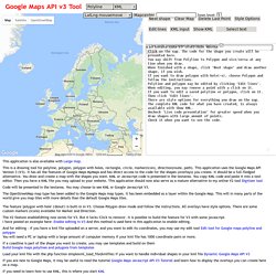
This is a drawing tool for polyline, polygon, polygon with holes, rectangle, circle, marker(icon), direction(route, path). This application uses the Google Maps API Version 3 (V3). It has all the features of Google Maps MyMaps and has direct access to the code for the shapes (overlays) you create. It should be a full-fledged alternative. You draw and create a map with the shapes you want. Code will be presented in the textarea. The OpenStreetMap map type has been added to the Google Maps map types. The feature 'polygon with hole' ('donut') is built-in in V3. The V2 feature enableEditing now exists for V3. And for editing - if you have a kml file uploaded on a server, and you want to edit its coordinates, you may use my edit tool Edit tool for Google maps polyline and polygon You will need a PC or laptop with a large amount of computer memory if your kml file has 1000 coordinate pairs or more.
Other useful links: Google Maps API links.
WEB.