
Discover Fascinating Vintage Maps From National Geographic's Archives. Cartography has been close to National Geographic’s heart from the beginning.
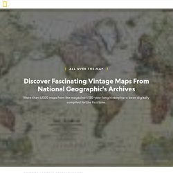
And over the magazine’s 130-year history, maps have been an integral part of its mission. Now, for the first time, National Geographic has compiled a digital archive of its entire editorial cartography collection — every map ever published in the magazine since the first issue in October 1888. The collection is brimming with more than 6,000 maps (and counting), and you’ll have a chance to see some of the highlights as the magazine’s cartographers explore the trove and share one of their favorite maps each day. Follow @NatGeoMaps on Twitter, Instagram, and Facebook to see what they discover. D-maps.com : free maps, free blank maps, free outline maps, free base maps. Living Atlas of the World. Color to Your Heart's Delight With These Historic Map Coloring Pages - Geolounge. Ye olde maps, converted to coloring pages.
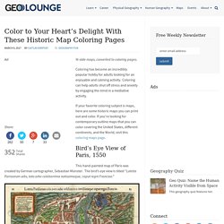
Coloring has become an incredibly popular hobby for adults looking for an enjoyable and calming activity. Coloring can help adults shut off stress and anxiety by engaging the mind in a mediative activity. If your favorite coloring subject is maps, here are some historic maps you can print out and color. If you’re looking for contemporary outline maps that you can color covering the United States, different continents, and the World, visit this coloring maps page. Bird’s Eye View of Paris, 1550. What the World Would Look Like if All the Ice Melted. This story appears in the September 2013 issue of National Geographic magazine.
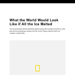
The maps here show the world as it is now, with only one difference: All the ice on land has melted and drained into the sea, raising it 216 feet and creating new shorelines for our continents and inland seas. There are more than five million cubic miles of ice on Earth, and some scientists say it would take more than 5,000 years to melt it all. If we continue adding carbon to the atmosphere, we’ll very likely create an ice-free planet, with an average temperature of perhaps 80 degrees Fahrenheit instead of the current 58. North America The entire Atlantic seaboard would vanish, along with Florida and the Gulf Coast. The True Size Of ...
Select Map Projections. This website uses cookies to improve your experience.
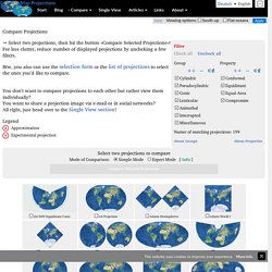
More info Compare Map Projections Deutsch • English [info] Viewing options: OverlapMaps - Instantly compare any two places on Earth! Livemap24. Kartutskrift.lantmateriet. MapFight - Denmark vs Sweden size comparison. Maps to be Used for the History of Europe. Euratlas Periodis Web shows the history of Europe through a sequence of 21 historical maps, every map depicting the political situation at the end of each century.
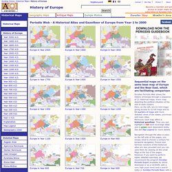
Here, on the left, are 21 mini-maps giving access to 21 full maps and to 84 quarters of maps with more detailed views of the states, provinces and main cities.Moreover, each map offers a historical gazetteer. Thus you can highlight in red each sovereign state and in green each dependent entity. See the Map Legend for more details. Navigation through the atlas is easy: on the left side of the pages, you simply need to choose a century for temporal navigation. French and German versions of this historical atlas are also provided and you can view them by clicking on the small flags at the top of the pages. History of the World: Every Year. Hint Fashion Magazine - Journal. #?borders=1~!MTc5OTc4NTE.NDc0Nw*MzYwMDAwMDA(MA~!CONTIGUOUS_US*MTAwMjQwNzU.MjU...
Free Vector Maps. Stora frågor=lärandemål. Maps That Prove You Don't Really Know Earth. Geografi. Huvudsidan - Globalis.se. Digitala kartor och källkritik. Digitala kartor förändrar undervisningen Den digitala tekniken har fullständigt revolutionerat användningen av kartor, inte minst inom skolans undervisning.
Tidigare var vi lärare hänvisade till de väggkartor som råkade finnas i klassrummet, de kartböcker skolan hade köpt in, de kartbilder som fanns i läroböckerna samt de köpta eller egenhändigt tillverkade overhead-bilder vi hade tillgång till. Antalet möjliga kartor att studera i klassrummet var därför starkt begränsat. Genom internet och annan digital teknik har både lärare och elever tillgång till ett mycket stort antal kartor från i stort sett hela världen på ett sätt som var helt otänkbart tidigare. Allt fler webbplatser publicerar digitala kartor och läromedelsförlagen har också följt med i utvecklingen och erbjuder sedan flera år kartor i digitalt format på cd-skivor eller via förlagens webbplatser.
Världskarta. Blindkarta över Världen. Världskartor - Globalis.se. Befolkning Den globala fördelningen av den snabbt växande befolkningen är mycket ojämn.
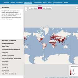
Skillnaderna beror till stor del på olikheter i klimat, markförhållanden, naturresurser och ekonomiska resurser. Bevarande av områden Biologisk mångfald Blank karta. FBA31F97C45242139CC98D73808D032B. Geoclopedia. Geografi spel. Geografi beskriver hur jordytan ser ut, förklarar varför den ser ut som den gör och sätter det i relation till hur människans aktivitet påverkar och påverkas av jorden.
Träna detta i dessa geografispel. Här har vi samlat alla spel inom ämnet Geografi. Spelen passar förskolan, grundskolan och ändå upp till gymnasiet. Sortera på hur populär spelen är, hur nya de är eller efter namn. Sveriges landskap. Geografiska undersökningar - fältstudier och geografiska informationssystem. Gis gör kartan konkret. – Här ska det ligga en båtkrog.
Folk ska kunna komma hit med båt och äta. Felix Wigström, Jonas Wachster och Sara Düsing pekar ut den vackra platsen på udden där deras restaurang ska ligga. Krogen ska vara öppen sommartid och leveranserna ska ske med båt. De undersöker väderstrecken, var kommer solen att vara? Scribblemaps: Skapa egna kartor. Drottningholm Palace panorama in Sweden - 360Cities. Europe is generally agreed to be the birthplace of western culture, including such legendary innovations as the democratic nation-state, football and tomato sauce.The word Europe comes from the Greek goddess Europa, who was kidnapped by Zeus and plunked down on the island of Crete.
Europa gradually changed from referring to mainland Greece until it extended finally to include Norway and Russia.Don't be confused that Europe is called a continent without looking like an island, the way the other continents do. It's okay. The Ural mountains have steadily been there to divide Europe from Asia for the last 250 million years. Russia technically inhabits "Eurasia".Europe is presently uniting into one political and economic zone with a common currency called the Euro. Huvudsidan - Globalis.se.
World Basic – Svenska. Worldmapper. Landguiden - länder i fickformat. Arcgis.com. HÖGSKOLAN I GÄVLE GIS-FILMEN. Kartor (Geografi) - Studi.se.