Isle of Skye Outdoors - 48 Isle of Skye Shops. Rha Waterfall. Kilt Rock. The famous Kilt Rock is a sea cliff in north east Trotternish.
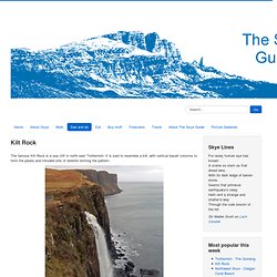
It is said to resemble a kilt, with vertical basalt columns to form the pleats and intruded sills of dolerite forming the pattern. The Mealt Waterfall, with the Kilt Rock beyond it. Braes Beach. Camas a' Mhòr Bheòil Camas a' Mhòr Bheòil, (or Braes Beach) has a lot going for it: It's fairly close to a roadIt's sheltered and sandyIt has a shallow slopeIt's close to caves, sea stacks and the site of an ancient fortIt has a superb view northwards up the Sound of Raasay to Beinn Tianabhaig To get to the beach, take the B883 from just south of Portree until reaching Gedintailor.
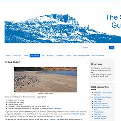
There, take the minor road that runs parallel, but slightly further east. A guide to walks on the Isle of Skye, from a stroll to a stretching expedition. Bruach na Frithe. From the east ridge of Bruach na Frithe Am Basteir (left), Sgurr a' Fionn Choire (right), Sgurr nan Gillean (behind) It is often said that Bruach na Frithe is the easiest Munro summit on the Cuillin Ridge, and one of the best viewpoints.
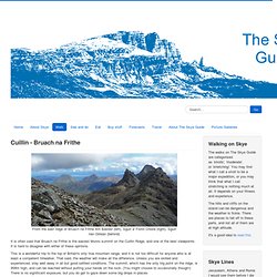
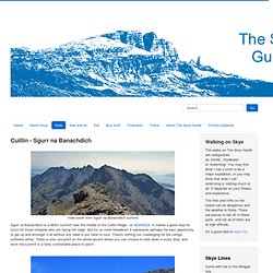
It is hard to disagree with either of these opinions. This is a wonderful trip to the top of Britain's only true mountain range, and it is not too difficult for anyone who is at least a competent hillwalker. That said, the weather will make all the difference. Unless you are skilled and experienced, stay well away in all but good settled conditions. Sgurr na Banachdich. View south from Sgurr na Banachdich summit Sgurr na Banachdich is a 965m summit near the middle of the Cuillin Ridge - at NG440224.
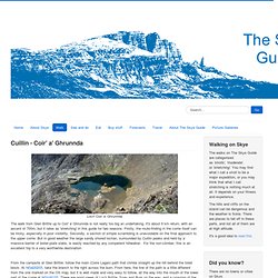
It makes a good stop for lunch for those intrepids who are 'doing the ridge'. But for us mere hillwalkers it represents perhaps the best opportunity to get up and amongst it all without any need to put hand to rock. There's nothing too challenging for the vertigo sufferers either. Coir' a' Ghrunnda. Loch Coir' a' Ghrunnda The walk from Glen Brittle up to Coir' a' Ghrunnda is not really too big an undertaking.
It's about 9 km return, with an ascent of 700m, but it rates as 'stretching' in this guide for two reasons. Firstly, the route-finding in the corrie itself can be tricky, especially in poor visibility. Secondly, a section of simple scrambling is unavoidable on the final approach to the upper corrie. But in good weather the large sandy shored lochan, surrounded by Cuillin peaks and held by a massive barrier of boiler-plate slabs, is easily reached by any competent hillwalker.
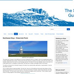
From the campsite at Glen Brittle, follow the main (Coire Lagan) path that climbs straight up the hill behind the toilet block. The Allt Coire Lagan - in benign mood From the steeply rising left turn into the lower corrie onwards, life gets more exciting. Waternish Point. Waternish Point Lighthouse The outing from Trumpan to the lighthouse on the tip of Waternish Point is a longish (14km) but straightforward walk in a totally unpopulated area of Skye.
There are two fine duns (brochs) to explore on the way, some fine cliff scenery, and fantastic views across the mouth of Loch Dunvegan and over The Minch to the Outer Hebrides. Much of the route it on a well defined track, so navigation is pretty easy, and there are no steep or prolonged climbs to be tackled. You will be a fair way from civilization though, so do take it as a serious walk, particularly in rough weather. It can be very windy out there! This is a great outing for watching wildlife. Your starting point is where the gated track leaves the public road at NG229616. This broch is certainly less complete than is Borrafiach, but a big passageway below the tumbled stonework makes an interesting diversion for those of us fascinated with such things. Dun Borrafiach, Waternish Point Unish House. Trotternish Ridge. Hear pronunciation Press to hear pronunciation One of the finest ridge traverses in Britain.
Spectacular views throughout. Terrain A very long and challenging walk with much ascent and descent; surprisingly for a major ridge there is no path most of the way, though there is much firm grassy going. Most people split it into a 2 day hike with a camp or bivvy on the ridge itself. Public Transport This is a linear walk finishing in Portree - public transport can be used to reach the start. Hillwalking in Winter Please note that hillwalking when there is snow lying requires an ice-axe, crampons and the knowledge, experience and skill to use them correctly.
Start Start of Loch Langaig/Harsco footpath, Flodigarry. Users' reports As well as reading our description of each walking route, you can read about the experiences of others users on this walk and others.There are 4 user reports for this walk - click to read them. Glamaig and the northern Red Hills. Hear pronunciation Press to hear pronunciation Glamaig and the northern Red Hills give a fine circuit with punishing scree but unparalleled views.
Terrain Very steep slopes of scree and stones have to be negotiated, particularly on Glamaig (which can be omitted). The lower ground is very boggy in places. Quiraing, circuit via summit. The Storr and the Old Man of Storr. Clothing and Equipment. Navigator's Dozen.