Technological
> Digital Environment Horizon Scan 2020
MicroCarb - eoPortal Directory - Satellite Missions. MicroCarb (Carbon Dioxide Monitoring Mission) Spacecraft Development Status Launch Sensor Complement References MicroCarb is a CNES microsatellite mission with the goal to monitor the fluxes of carbon dioxide (CO2) at the surface between the atmosphere and the oceans and vegetation.
A better knowledge of the carbon flux is needed to: 1) 2) • Understand the functioning of the vegetation (yearly cycle, response to meteorological anomalies) • Identify and quantify the terrestrial ecosystem Carbon sinks and sources at yearly scales (where are the Carbon sinks/sources; how do they evolve with the climate changes) • Quantify the oceanic Carbon sources and sinks at yearly scales and their responses to the announced climate changes • Contribute to the measurement of Carbon emission linked to fossil fuels use. The idea of MicroCarb is to develop a mission able to compete with large satellite ones in terms of performances while keeping the cost as low as possible.
Infrastructure
How can Big Data and machine learning benefit environment and water management: a survey of methods, applications, and future directions. CarbonChain is using AI to determine the emissions profile of the world’s biggest polluters. TechCrunch fait partie de Verizon Media.

Nos partenaires et nous-mêmes stockerons et/ou utiliserons des informations concernant votre appareil, par l’intermédiaire de cookies et de technologies similaires, afin d’afficher des annonces et des contenus personnalisés, de mesurer les audiences et les contenus, d’obtenir des informations sur les audiences et à des fins de développement de produit. Données personnelles qui peuvent être utilisées Informations sur votre appareil et sur votre connexion Internet, y compris votre adresse IP Navigation et recherche lors de l’utilisation des sites Web et applications Verizon Media Position précise Découvrez comment nous utilisons vos informations dans notre Politique relative à la vie privée et notre Politique relative aux cookies. Pour autoriser Verizon Media et nos partenaires à traiter vos données personnelles, sélectionnez 'J'accepte' ou 'Gérer les paramètres' pour obtenir plus d’informations et pour gérer vos choix.
How ai can enable a sustainable future. Using AI To Help Businesses Go Carbon Neutral. Carbon Credentials is an energy management company using AI systems to help businesses reduce carbon emissions.
Working with retail giants such as Tesco and John Lewis, the company, which has 60 employees, uses its AI platform to analyze 12 million rows of data every day, to assess the energy performance of more than 40,000 buildings across the world. As organizations face mounting pressure to commit to carbon reduction, the company's CEO Paul Lewis, who lives in London with his wife and daughter, explains why his company is so important in helping businesses achieve the carbon neutral dream. LS: So what is your business all about? PL: Making a positive impact.
SOLSTICE MOOC. Introduction This free 4-week online course, Ocean Science in Action: Addressing Marine Ecosystems and Food Security in the Western Indian Ocean, will be available from 5th October 2020.
It will introduce you to innovative marine technologies and their applications used to tackle the challenges of the sustainable management of marine ecosystems.
ERDDAP - Home Page. ERDDAP is a data server that gives you a simple, consistent way to download subsets of gridded and tabular scientific datasets in common file formats and make graphs and maps.
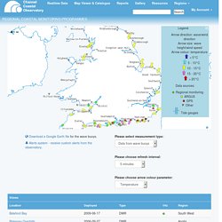
This particular ERDDAP installation has oceanographic data (for example, data from satellites and buoys). Please change to https now! Access to this ERDDAP is now https only. Attempts to use http will be redirected to https, but that redirect may fail in some scripts. Please change your bookmarks and scripts to https now to avoid trouble. Easier Access to Scientific Data. Channel Coastal Observatory Real time data. Legend Arrow direction: wave/wind directionArrow size: wave height/wind speedArrow colour: temperature < 5°C 5 - 10°C 10 - 15°C15 - 20°C > 20°CArrow colour: Wave height< 0.1 m 0.1 - 0.5 m 0.5 - 1 m1 - 5 m > 5 mArrow colour: Peak period< 8 s 8 - 12 s 12 - 16 s16 - 20 s > 20 s Tide ruler: tide height (CD) Data sources: Regional monitoringARGUSGPSOtherTide gauges We would appreciate your feedback on the new Website and Map Viewer.
CoastSnap - SWRCMP. Estimation of global coastal sea level extremes using neural networks. Accurately predicting total sea-level including tides and storm surges is key to protecting and managing our coastal environment.
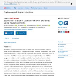
However, dynamically forecasting sea level extremes is computationally expensive. Here a novel alternative based on ensembles of artificial neural networks independently trained at over 600 tide gauges around the world, is used to predict the total sea-level based on tidal harmonics and atmospheric conditions at each site.
The results show globally-consistent high skill of the neural networks (NNs) to capture the sea variability at gauges around the globe.
An experiment to test satellite radar interferometry-observed geodetic ties to remotely monitor vertical land motion at tide gauges. WireWall – a new approach to measuring coastal wave hazard - NERC Open Research Archive. Brown, Jennifer ORCID: Yelland, Margaret ORCID: Pascal, Robin; Pullen, T.; Cardwell, Christopher; Jones, David; Pinnell, Richard; Silva, E.; Balfour, Christopher; Hargreaves, Geoff ORCID: Martin, Barry; Bell, Paul ORCID: Prime, Thomas; Burgess, Jill; Eastwood, Lisa; Martin, A.; Gold, I.; Bird, Cai; Thompson, C.; Farrington, B.. 2020 WireWall – a new approach to measuring coastal wave hazard.
Low Cost GNSS Tide & Sea Level Measurements for Intertidal public safety (LoCTIPS) - NERC Open Research Archive. Demonstrating the Potential of Low Cost GPS Units for the Remote Measurement of Tides and Water Levels Using Interferometric Reflectometry. Earth observation for sustainable development. GI - Dense point cloud acquisition with a low-cost Velodyne VLP-16. Amiri Parian, J. and Grün, A.: Integrated laser scanner and intensity image calibration and accuracy assessment, Int.
Arch. Photogramm., 36, 18–23, 2005.
Accenture Technology Vision 2020 Full Report. 4 big tech trends for 2021 - brand post - Hindustan Times. The tech industry is constantly evolving in a chain reaction of rapid technological developments.
No matter where you are based in the world, it is nearly impossible to escape the way new technologies are reshaping everyday life. So, how will your work and personal life be changed by technology in the next 12 months?
Digital Earth Challenges and Future Trends. 26.2.1 Big Data Management in Digital Earth In discussing the challenges highlighted in earlier chapters of this manual, the authors have demonstrated the tremendous volume, variety, veracity, and velocity (the four Vs) challenges for Big Earth Data (Guo et al. 2017; Yang et al. 2017).
Some tech mentioned here is well understood. New to me were: Hyper connectivity, Edge/fog computing and in-memory computing and processor advances – tomaugust
The four Vs impose new requirements on computing, data management, information extraction, and knowledge discovery, as well as the detection of events of interest, needed to realize the value (the fifth V) of Big Earth Data for Earth science and applications (Guo et al. 2014; Lee and Kang 2015; Shu 2016;Yang et al. 2019).
Gartner Top 10 Strategic Technology Trends for 2020. Hyperautomation, blockchain, AI security, distributed cloud and autonomous things drive disruption and create opportunities in this year's strategic technology trends. Human augmentation conjures up visions of futuristic cyborgs, but humans have been augmenting parts of the body for hundreds of years. Glasses, hearing aids and prosthetics evolved into cochlear implants and wearables. Even laser eye surgery has become commonplace. But what if scientists could augment the brain to increase memory storage, or implant a chip to decode neural patterns?
What if exoskeletons became a standard uniform for autoworkers, enabling them to lift superhuman weights?
Global Environment Monitoring and Sensing Market Projected to be Worth USD 20.37 Billion by 2021: Technavio. Top 10 Strategic Technology Trends for 2019. Blockchain, quantum computing, augmented analytics and artificial intelligence will drive disruption and new business models. Read more: Gartner Top 10 Strategic Technology Trends for 2020 Although science fiction may depict AI robots as the bad guys, some tech giants now employ them for security.
Companies like Microsoft and Uber use Knightscope K5 robots to patrol parking lots and large outdoor areas to predict and prevent crime. The robots can read license plates, report suspicious activity and collect data to report to their owners. These AI-driven robots are just one example of “autonomous things,” one of the Gartner Top 10 strategic technologies for 2019 with the potential to drive significant disruption and deliver opportunity over the next five years.
COVID-19: Post-Coronavirus technology trends. A new look at our 2020 Technology Vision trends When we published Accenture’s 2020 Technology Vision report, COVID-19 was not yet a global pandemic.
Now, it’s the greatest challenge the world has faced in decades. In just a few short months, it’s transformed people’s lives on an unprecedented scale, impacted every industry, and altered the course of companies’ growth. But the pandemic has not slowed innovation—it’s amplifying it to historic levels.
Environmental Monitoring Market Growth, Trends and Forecast (2020-2025)
The MarketWatch News Department was not involved in the creation of this content.
May 01, 2020 (Heraldkeepers) -- New York, May 01, 2020: The scope of the report includes a detailed study of global and regional markets on Environmental Monitoring Market with the reasons given for variations in the growth of the industry in certain regions. The Environmental Monitoring Market is expected to be around US$ 24.30 Billion by 2025 at a CAGR of 7.7% in the given forecast period.
Real-World Laboratories: Research Infrastructures for Open Innovation and Citizen Science. By Birgit Fingerle Real-world laboratories or living labs have become increasingly beloved over the last five years.
Real World Labs, trendy in Germany, the concept of (co)designing and testing social/economic (and presumably environmental) questions through large scale experiments whereby people and other actors within a defined area / system structure their interactions within that area to answer the questions. Enables social aspects to be brought into experiments at early stage. – mattfry
10 Predictions about the Future of Small Satellites and New Space. Innovation forms an integral part of the DNA of the space industry.
More than 1200 CubeSats have been launched as of January 2020, many for experimentation. Will drive innovation in satellite technology, including onboard AI, propulsion, large constellations of focussed and coordinated satellites. – mattfry
The Future of Earth Observation – SatelliteObservation.net. Persistent observation, a persistent problem For all the improvements in spatial and spectral resolution, agility and accuracy, satellites suffer from one serious drawback: they have to follow the laws of orbital mechanics and keep moving around the Earth. This means they cannot hang around an interesting location, to keep a persistent watch on it, except… Continue reading High-altitude Pseudosatellites, the future of Earth observation?
In the article on Persistent Surveillance, I described the options for keeping a constant, 24/7 watch on a location though the use of high-altitude satellites.
NASA's Earth Observing System. High-altitude Pseudosatellites, the future of Earth observation? – SatelliteObservation.net. Persistent observation, a persistent problem For all the improvements in spatial and spectral resolution, agility and accuracy, satellites suffer from one serious drawback: they have to follow the laws of orbital mechanics and keep moving around the Earth.
This means they cannot hang around an interesting location, to keep a persistent watch on it, except if they are in geostationary orbit. However, geostationary orbit is so far from the Earth that to get any kind of reasonable resolution (say 1m), huge mirrors are required (20m for a 1m resolution), making this an unworkable proposition in the near term for optical surveillance. Alternatives exist, in the form of large constellations that always have at least one satellite over the area of interest.
The Pros, Cons, And Predictions For A OneWeb UK GNSS. It was announced last week that a consortium including the UK Government has won the bid to rescue the OneWeb satellite constellation from bankruptcy. This has been much heralded in the press as the opportunity for the UK to secure its own Global Navigation Satellite System (GNSS) after Brexit has reduced our access to the secure components of the Galileo system.
Some observers have however declared that the UK has bought the wrong satellites for this.
Seamless Synthetic Aperture Radar (SAR) Archive for Interferometry Analysis. Principal Investigator (PI): Charles Meertens, UNAVCO. Synthetic Aperture Radar (SAR) is About to Revolutionize Commercial Earth Observation. Small-Satellite Synthetic Aperture Radar for Continuous Global Biospheric Monitoring: A Review. 1. Introduction. Mills 2020.
Unlocking the value in data as a commons. These enable people to share their data, anonymously, for specific purposes or social benefit. Some data commons specialise in particular types of data, such as health, and have a very specific purpose. These commons are not open to the public in the same way, as the data is far more sensitive and members of the commons use the restriction as leverage to give themselves a voice and stake in how it used.
Towardsdatascience. iEcology: harnessing large online resources to generate ecological insights. Conservation culturomics. AI revolution in science. Near Real-time Autonomous Quality Control for Streaming Environmental Sensor Data. Abstract. State Tagging for Improved Earth and Environmental Data Quality Assurance.
Introduction. Imputation of missing sub-hourly precipitation data in a large sensor network: A machine learning approach. Automatic Quality Control Procedure. AI at the Edge - FierceElectronics. Edge Machine Learning for AI-Enabled IoT Devices: A Review. DataRobot Artificial Intelligence Wiki. AI for biodiversity data collation and reuse — Katina Michael. Simplifying the Data Consolidation Process with Machine Learning - IceCream Labs. Machine Learning-Based Calibration of Low-Cost Air Temperature Sensors Using Environmental Data. In Situ Calibration Algorithms for Environmental Sensor Networks: a Review.
Improving Data Quality of Low-cost IoT Sensors in Environmental Monitoring Networks Using Data Fusion and Machine Learning Approach. [1806.06762] Agricultural Robotics: The Future of Robotic Agriculture. Small Robot Company. Development of Digital Identity Trust Framework confirmed. Infrastructure and Industrialization – United Nations Sustainable Development. Environmental Impact Monitoring and Reporting - Ecometrica. Utilization of Biosensors for Environment Monitoring. Introducing the geostationary environment monitoring spectrometer.
South Korean air quality satellite, similar to Sentinel 5(?) – mattfry
Evaluating the efficacy of small‐scale marine protected areas for preserving reef health: A case study applying emerging monitoring technology. Emerging opportunities and challenges for passive acoustics in ecological assessment and monitoring. Mobile phone-based biosensing: An emerging “diagnostic and communication” technology. Digital PCR as an Emerging Tool for Monitoring of Microbial Biodegradation.
Extended Epistemology. GRS: The green, reliability, and security of emerging machine to machine communications. Digital twins to monitor infrastructure could save billions - Smart Cities - Osborne Clarke. Citizen science in hydrological monitoring and ecosystem services management: State of the art and future prospects. Demonstrating the value of community-based (‘citizen science’) observations for catchment modelling and characterisation. Paper Based Sensors for Environmental Monitoring.
Disposable Sensors in Diagnostics, Food, and Environmental Monitoring - Dincer - 2019 - Advanced Materials.
Wide ranging discussion of current and upcoming disposable sensors, with section on environmental monitoring specifically. Hard to gauge viability. Useful summary: “lmproved access to inexpensive, disposable sensing devices is enabling citizens to measure and participate in the protection of the environment and impact policy makers. This, in turn, forces governments to adopt new laws and regulations that would (hopefully) eventually help with the protection of the environment for the future generations.” – mattfry
Environmental monitoring equipment and sensor solutions. TRUTHS - NPL. A review of in situ methods and sensors for monitoring the marine environment. Trends in the use of passive sampling for monitoring polar pesticides in water. Analytical methods for microplastics. Water quality monitoring using wireless sensor networks: Current trends and future research directions.
Low-Cost Environmental Sensor Networks: Recent Advances and Future Directions. Internet of Ships: A Survey on Architectures, Emerging Applications, and Challenges. A Low-Cost Smart Sensor Network for Catchment Monitoring. Wireless sensor networks: A survey on monitoring water quality. Novel soil sensor projects within Signals in the Soil call.
