
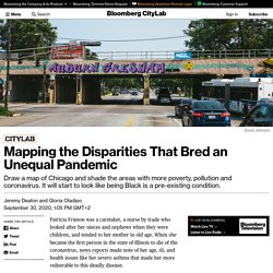
Mapping the Disparities of Chicago's Unequal Pandemic. Patricia Frieson was a caretaker, a nurse by trade who looked after her nieces and nephews when they were children, and tended to her mother in old age.
Aerosol transmission of Covid-19: A room, a bar and a classroom: how the coronavirus is spread through the air. The coronavirus is spread through the air, especially in indoor spaces.
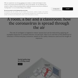
While it is not as infectious as measles, scientists now openly acknowledge the role played by the transmission of aerosols – tiny contagious particles exhaled by an infected person that remain suspended in the air of an indoor environment. How does the transmission work? And, more importantly, how can we stop it? These are respiratory droplets that are less than 100 micrometers in diameter that can remain suspended in the air for hours. Tracking Coronavirus Cases at U.S. Colleges and Universities. When It Comes to Covid-19, Density Doesn’t Kill—Sprawl Does – Common Edge. Since the advent of Covid-19, there has emerged a critique of urban density as deadly in fighting the current and future pandemics, and that the answer lies in dispersed development, otherwise known as sprawl.
But a new study on density related to coronavirus infection and mortality rates released by the Johns Hopkins University School of Public Health challenges much of this “conventional wisdom.” The study was led by Shima Hamidi, Bloomberg Assistant Professor of American Health in Environmental Challenges and a planner, urban designer, and Smart Growth advocate. Her research examined data from more than 900 metropolitan counties across the U.S. and concluded that there is no correlation between density and infection rates, but higher death rates in places described as “sprawl.”
Pandemic Data for Planners - Blogs. As many cities and countries around the world start emerging from COVID-19 lockdowns, city planners are thinking strategically about moving ahead with projects while staying mindful of the factors that could promote or harm public health.
Making progress in those aims requires staying abreast of trends and responding accordingly, and recently collected pandemic can shape the future of cities. Showing How the Coronavirus Impacts Counties, Cities and States Comparing how different places fared during the coronavirus pandemic could encourage city planners to dig deeper and examine the positive and negative factors that caused such outcomes. Some local authorities are making this information publicly available to help residents and others stay informed as the pandemic continues. Boston has a COVID-19 Case Tracker that shows national data, along with statistics for Massachusetts and the city.
Maintaining readily available data will undoubtedly remain a challenge moving forward. The U.S. Being more densely populated doesn’t boost COVID-19 spread, a University of Utah study finds. Contrary to popular perception, densely populated U.S. city centers are not more prone to the spread of COVID-19, a newly released study by University of Utah researchers has concluded.
Urbanized counties with higher densities, in fact, had significantly lower death rates, which researchers said might be explained by better social distancing and access to health care. The results, said co-author Reid Ewing, professor at the U. ‘s Department of City & Metropolitan Planning, “run counter to the recent narrative about escaping compact cities for sprawling suburbs as a way of staying safe from COVID-19.” “Our main finding is that density isn’t the driving force behind very high infection and death rates. Rather, it’s metropolitan area size,” Ewing said Thursday in an interview. “Compact places seem to promote better adherence to social distancing and provide better acute health care,” Ewing said, “so those contracting the coronavirus are less likely to die.” Being more densely populated doesn’t boost COVID-19 spread, a University of Utah study finds.
County Health Rankings & Roadmaps. COVID-19 Community Mobility Reports. Each Community Mobility Report is broken down by location and displays the change in visits to places like grocery stores and parks. Learn more about the data. We’re working to add more countries, regions and languages in the coming weeks. This is an early release and reports will be updated regularly. The Community Mobility Reports were developed to be helpful while adhering to our stringent privacy protocols and protecting people’s privacy. No personally identifiable information, such as an individual’s location, contacts or movement, will be made available at any point. Insights in these reports are created with aggregated, anonymized sets of data from users who have turned on the Location History setting, which is off by default.
We also use the same world-class anonymization technology used in our products every day to keep your activity data private and secure. Visit Google's Privacy Policy to learn more about how we keep your data private, safe and secure. COVID-19 Funding Opportunities - Research Matters. Report: Expect to Live with Two More Years of Social Distancing - News. "Our goal is to help planners envision some of the situations that might present themselves later this year or next year so that they can take key steps now, while there’s still time," states a description to the new series of weekly reports to be published by the Center for Infectious Disease Research and Policy (CIDRAP) at the University of Minnesota under the title, "COVID-19: The CIDRAP Viewpoint.
" Based on the four flu pandemics that have taken place since 1900: 1918-19, 1957, 1968, and 2009-10, the researchers concluded that the coronavirus outbreak will likely last 18 to 24 months. "This thing's not going to stop until it infects 60 to 70 percent of people," Mike Osterholm, who directs CIDRAP, told CNN (source article). "The idea that this is going to be done soon defies microbiology. " Osterholm has been writing about the risk of pandemics for 20 years and has advised several presidents. Messaging Herd immunity through vaccine or infection. The 10 cities best-positioned for pandemic recovery. Dive Brief: A recent report from Moody's Analytics highlighted the cities that are in the best and worst positions to recover from the coronavirus pandemic.
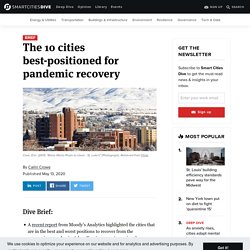
Adam Kamins, a senior regional economist at Moody's Analytics, found the "most dynamic recoveries" won't be in urban powerhouses like New York City, but instead in "areas that either were or were poised to lead the way in 2020 before everything changed. "The 10 best-positioned cities are (alphabetically): Boise, ID; Denver; Durham, NC; Madison, WI; Provo, UT; Raleigh, NC; Salt Lake City; San Jose, CA; Tucson, AZ; and Washington, DC, according to reporting from Forbes.The 10 cities worst-situated to recover from the coronavirus are (alphabetically): Detroit; Honolulu; Los Angeles; McAllen, TX; Miami; New Haven, CT; New York City; Philadelphia; Stockton, CA; and Tampa, FL.
Dive Insight: Urban Planning Resources for COVID-19 - Features. It isn't premature to declare 2020 the year of the coronavirus.

Every prediction made in December and January about the trends that would define this year were wrong—mine included. In 2020, auto manufacturers are making ventilators. Jeans companies are making masks. Public transit is empty, and cars stay at home all day long. The Internet, until recently a platform devoted to the sole purpose of pledging fealty to U.S. presidential candidates, now reads like a 24-hour shopping network for coronavirus hot takes. Researchers explore effects of COVID-19 on urban mobility. Dive Brief:
ASU scientists searching sewers for traces of COVID-19. In the Center for Environmental Health Engineering at Arizona State University's Biodesign Institute, researchers are identifying the prevalence of local coronavirus cases by tapping into the dirtiest part of any city: the sewer.
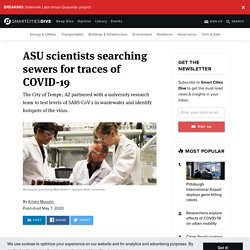
Through a research partnership with the City of Tempe, AZ, Professor Rolf Halden and his team of researchers are using years-old technology to better understand the new coronavirus. Through wastewater testing, the team can identify regional levels of SARS-CoV-2 — the virus that causes COVID-19 — and identify viral hotspots in the city. That data can then be used to implement effective policies and measures to improve public health. Halden, who's been studying wastewater epidemiology for over a decade and wrote a book on the topic, said the cheap, quick testing is a powerful way to track and prevent the current spread of coronavirus. "We always learn after the fact," Halden told Smart Cities Dive when describing the need for more preventative testing. COVID-19 Resources. The novel coronavirus (COVID-19) pandemic is having a significant impact on communities, and planners are on the front lines of response and recovery.
APA is committed to providing resources, information, and tools to address your immediate needs and help you prepare for what is to come. Learn more about how we are using the practice of foresight to "learn with the future," prepare for uncertainty, and navigate this disruptive change. Report: COVID-19 U.S. County Study.