
UK Lakes. Data.gov.uk. World Health Organization. Global Strategy for Women's, Children's and Adolescents' Health (2016-2030): Data portal The Every Woman Every Child Global Strategy indicator and monitoring framework includes 60 indicators from health and other sectors. 34 indicators are from the Sustainable Development Goals (SDGs) and 26 from related global monitoring initiatives.
From these, 16 key indicators are highlighted to provide a snapshot of progress. The World Bank. Population Reference Bureau. OS OpenData. Try our data If you want to try Open Data today as either a download or DVD, please use our online ordering portal.

Order now OS OpenSpace Using the OS OpenSpace API, you can embed and annotate our maps for free on your non-commercial website or mobile app. London Datastore – Greater London Authority. CHESS. Human Development Index, 2014 - Our World In Data. USGS Earth Explorer: Download Free Landsat Imagery. The USGS Earth Explorer is a similar tool to the USGS Global Visualization Viewer (GloVis) in that users search catalogs of satellite and aerial imagery.
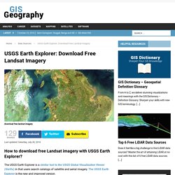
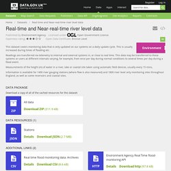
The USGS Earth Explorer is the new and improved version. The USGS Earth Explorer gives some extra capabilities: Data Sources Archives - GIS Geography. Your national on-line library for local history. Gapminder: Unveiling the beauty of statistics for a fact based world view. Environment.data.gov.uk. Real-time and Near-real-time river level data - Datasets. Openness rating: Reason: Content of file appeared to be format "CSV" which receives openness score: 3. ★★★★★ Linked data - data URIs and linked to other data (e.g.
RDF) World climate data - Temperature, Weather and rainfall. Free climate data for ecological modeling and GIS. National Centers for Environmental Information (NCEI) formerly known as National Climatic Data Center (NCDC) UK Data Service Census » Census boundary data. We provide access to digitised boundary datasets and geographic look-up tables corresponding to the census geography of the UK.
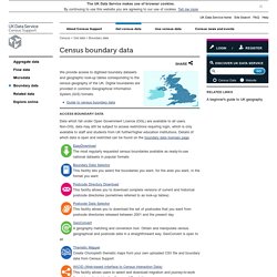
Digital boundaries are provided in common Geographical Information System (GIS) formats. Guide to census boundary data Access boundary data Data which fall under Open Government Licence (OGL) are available to all users. Non-OGL data may still be subject to access restrictions requiring login, which is only available to staff and students from UK further/higher education institutions. Home - I-Use - statistics for education. NASA Earth Observations (NEO) UNEP Environmental Data Explorer - The Environmental Database (search. Downloads.
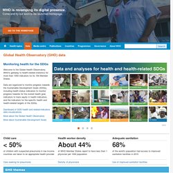
Data themes are available in three levels of detail. For each scale, themes are listed on Cultural, Physical, and Raster category pages. Stay up to date! Know when a new version of Natural Earth is released by subscribing to our announcement list. Overwhelmed? Geohive - Population Statistics. World Health Statistics 2016: Monitoring health for the SDGs. World Statistics - International statistics. Local Authority Dashboard. OpenDataCommunities. Check Browser Settings. U.S. Geological Survey Science Data Catalog.
Featured Dataset Nonindigenous Aquatic Species Database Marine Fishes Data Source: USGS Wetlands and Aquatic Research CenterBegin Date: 01/01/1878.
EarthExplorer. Centre for Ecology & Hydrology. National River Flow Archive. Data.gov.uk. Population data - Eurostat. Population data is available by various characteristics and can be grouped around the following topics: Ageing and population structure: based on the data available the ageing trends can be followed throughout the past decades.
Information on age groups and their share in the total population are available by country and at EU, Eurozone, EFTA and EEA aggregate level. Indicators such as the age dependency ratio are calculated on the basis of the population structure. 2015 World Population Data Sheet. Download: 2015 World Population Data Sheet (PDF: 2.5MB) Explore: Digital Visualization Visit: Interactive Map Teach: Lesson Plan (August 2015) Women worldwide are achieving gains in key barometers of personal well-being, but far more progress is needed to foster real gender equality and empower women, according to the Population Reference Bureau (PRB).
These findings are based on the 2015 edition of PRB’s annual World Population Data Sheet and a related package of interactive data features, all produced by PRB and released today at worldpopdata.org. This year’s Data Sheet provides the latest data on 20 population, health, and environment indicators for the world, major regions, and more than 200 countries. It includes a special set of indicators and analytical graphics aimed at assessing the state of women’s empowerment globally. For example, PRB analysis shows that earnings gaps between men and women persist despite women’s educational gains. Population and migration - Office for National Statistics. Statistics. Home - I-Use - statistics for education. ONS Geography Portal. Environment Agency - data.gov.uk. Met Office DataPoint. 2011 Census - Office for National Statistics.