
This spectacular "blue marble" image is the most det… Possible Threats to Earth. Very Weird Things Are Happening to Earth’s Magnetic Poles. Earth’s magnetic field is acting up and geologists don’t know why. Update, 9 January: The release of the World Magnetic Model has been postponed to 30 January due to the ongoing US government shutdown.
Interactive map plots your address over 750 million years of Earth's history. As recent volcanic events in both Hawaii and Guatemala have reminded us, our planet is alive and ever-changing.
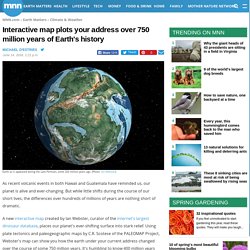
But while little shifts during the course of our short lives, the differences over hundreds of millions of years are nothing short of dramatic. A new interactive map created by Ian Webster, curator of the internet's largest dinosaur database, places our planet's ever-shifting surface into stark relief. Using plate tectonics and paleogeographic maps by C.R.
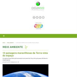
Cymatics! Song of Earth - NASA Voyager Recordings - Audio Visualization by Jess-E. 13 paisagens maravilhosas da Terra vista do espaço – CicloVivo. Os registros foram feitos pelo astronauta norte-americano Terry Virts, que passou 200 dias em missão espacial. 22 de abril de 2016 • Atualizado às 12 : 00 Suld a Flórida, Cuba e Bahamas. | Foto: Terry W.
Virts O astronauta norte-americano Terry Virts passou 200 dias em uma missão espacial internacional da Nasa. O período foi suficiente para que ele registrasse belas imagens da Terra vista além de sua órbita. 1. “O deserto da Namíbia tem algumas das maiores dunas de areia do mundo. 2. “Eu precisei até do meu último dia no espaço para conseguir uma boa foto das pirâmides.” – Terry W. 3. 4. “Califórnia parecendo muito marrom na região central e nebulosa na costa.” – Terry W. 5. Perda do gelo polar está modificando a rotação da Terra, diz NASA – CicloVivo. A Groenlândia perde 287 bilhões de toneladas de gelo por ano.
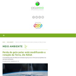
A Terra precisa equilibrar isso com outro movimento. 25 de julho de 2016 • Atualizado às 22 : 35 As mudanças nas camadas de gelo são monitoradas e estudadas há mais de cem anos. | Foto: NASA O derretimento dos gelos nos polos pode estar alterando o ângulo de rotação da Terra. Essa é uma das hipóteses levantadas por pesquisadores da NASA em um estudo recente, que analisou o eixo em que o planeta gira.
As mudanças nas camadas de gelo são monitoradas e estudadas há mais de cem anos. Além da mudança na direção, também foram identificadas modificações na velocidade deste deslocamento. Adhikari ainda esclarece como o movimento dos polos interfere na rotação terrestre. Apesar de não garantir que a mudança rotacional está diretamente ligada às mudanças climáticas, o derretimento das geleiras é uma das principais causas sugeridas.
Clique aqui para acessar o estudo completo. Study: Earth has its own 'Star Trek'-style force field. The University of Colorado Boulder has announced a discovery 7,200 miles above Earth of a protective shield similar to the force fields you might see in "Star Trek.
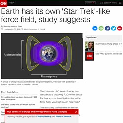
" The discovery of this barrier in the Van Allen radiation belts suggests a new explanation for how "killer electrons" are held at bay. This invisible shield, which was found at the inner edge of the outer Van Allen belt, protects against high-energy electrons, which have the potential to fry satellites, threaten astronauts and degrade space systems during intense solar storms. MIT scientists: There is an invisible force field protecting Earth. Ivan Ivan has been part of the team at Universe Explorers since February 2015.He is a freelance writer, editor-in-chief of ancient-code.com He also writes for Svemir Online and Ancient Origins.History, Archaeology, Space and world’s mysteries are some of the topics he writes about.You can follow Ivan on Facebook" Latest posts by Ivan (see all) MIT scientists discovered an invisible force field protecting Earth.
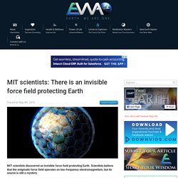
Scientists believe that the enigmatic force field operates on low-frequency electromagnetism, but its source is still a mystery. It turns out that there is an invisible force field protecting our planet. EWAO The Earth Grid. Our Planet is unique, (so far) Earth is the only planet capable of sustaining life in our Solar System and so far in the universe, but what makes it more unique is the megalithic monuments that are scattered across the globe.
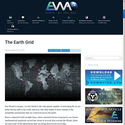
Places connected with straight lines, where advanced forms of geometry are found, mathematical equations carved into stone in several sites around the Planet, these are just some of the phenomena that are being discovered even today. Why were the Pyramids of Egypt built? How did the Ancient Egyptians manage to place the Great Pyramid of Giza at the exact center of all land mass on Earth?
The east/west parallel that crosses the most land and the north/south meridian that crosses the most land intersect in two places on the earth, one in the ocean and the other at the Great Pyramid. How was this possible without the ability to fly? We believe that these monuments were not placed randomly. Image credit: Scientists to drill into asteroid impact that wiped out dinosaurs.
Incredibly Detailed, Billion-Year-Old Ancient Maps Of Earth Produced By Researchers. Our planet has changed rapidly and violently through geological time, its continents and oceans fracturing and forming in incredible cycles.
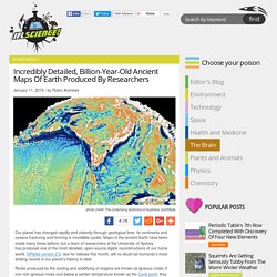
Scientists have used groundbreaking technology to figure out how the Earth looked a billion years ago. By the time Dietmar Mueller arrived at the University of Texas as a graduate student in the mid-1980s, scientists had already long embraced a once-astonishing idea: that the continents on which all human history has unfolded, rather than fixtures of constancy, were orphans of a former grand supercontinent called Pangaea.
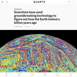
Showered with awards, the pioneers of this theory—plate tectonics—had by and large dispersed in search of the next big challenge. But Mueller and his classmates sensed far more ground to cover. Three decades later, Mueller, now at the University of Sydney, is part of a new upheaval in tectonics, this time ignited by advances in computing power. The same leaps in big-data analysis, supercomputing, and intelligent algorithms that have shaken up finance, genetics, and espionage are transforming our view of the elusive ancient world. A Giant Underground "Ocean" Has Been Discovered Beneath The Earth's Surface. A new study by American researchers concluded that in the mantle layer that lies between the crust and the core, there are vast reserves of water, probably three times the total volume of water of all oceans on the surface of our planet.
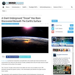
This “reservoir” of water, which seems to be stable over time, lies at a depth of up to 700 kilometers beneath the planet’s surface, in the intermediate zone between the upper and the lower mantle. The researchers, led by geophysicist Steven Jacobsen of the Northwestern University and seismologist Brandon Schmandt of the University of New Mexico, estimate that water is “locked” (molecularly trapped) in a mineral called ringwoodite.
This is a relatively rare crystalline structure with a rock formed from olivine under very high pressures and temperatures.