
Open Cache Manager - Linux Links - The Linux Portal Site - Nightly (Build 20110507043313) Open Cache Manager (OCM) is an easy to use program for managing your geocaches, with the goal of being the Linux equivalent to GSAK.
OCM integrates with GPSBabel to support most GPS devices. This software allows you to organize and store geocaching information in one or more databases. You can use filters to search databases, create bookmark lists of caches, keep notes on caches, and store additional waypoints. Features include: Return to GPS Tools Home Page. Nightly (Build 20110507043313) QLandkarte - Linux Links - The Linux Portal Site - Nightly (Build 20110507043313) QLandkarte GT is a versatile tool for GPS maps in GeoTiff format as well as Garmin's img vector map format.
QLandkarteGT is the successor of QLandkarte. Among various improvements (e.g. 2D/3D map rendering and reduced resource requirements) the major difference is its device-independent architecture, which is not limited to Garmin devices anymore. Additionally, it is the PC-side front end to QLandkarte M, a moving map application for mobile devices QLandkarte GT serves as a frontend to the GDAL tools, to make georeferencing of scanned maps feasible for users. In contrast to similar tools (e.g. Features include:
Welcome to QLandkarte GT/M - Nightly (Build 20110507043313) Navit - Linux Links - The Linux Portal Site - Nightly (Build 20110507043313) Navit is a car navigation system with routing engine.
Its modular design is capable of using vector maps of various formats for routing and rendering of the displayed map. It's even possible to use multiple maps at a time. The GTK+ or SDL user interfaces are designed to work well with touch screen displays. Points of Interest of various formats are displayed on the map. The current vehicle position is either read from gpsd or directly from NMEA GPS sensors. The routing engine not only calculates an optimal route to your destination, but also generates directions and even speaks to you using speech-dispatcher.
Navit - Car navigation system - Nightly (Build 20110507043313) GPSBabel - Linux Links - The Linux Portal Site - Nightly (Build 20110507043313) GPSBabel is open source software for GPS file conversion and transfer to/from GPS units.
It has a command-line interface and a graphical interface. GPSBabel converts waypoints, tracks, and routes from one format to another, whether that format is a common mapping format like Delorme, Streets and Trips, or even a serial upload or download to a GPS unit such as those from Garmin and Magellan. It also has powerful manipulation tools for such data.
GPSBabel supports dozens of data formats and will be useful for tasks such as geocaching, mapping, and converting from one GPS unit to another. Among the interesting formats it supports are several GPS devices via a serial link, various PDA-based mapping programs, and various Geocaching data formats. GPSBabel is popular in the Geocaching community because it enables people with incompatible GPS units to share data. Features include: GPSBabel: convert, upload, download data from GPS and Map programs - Minefield. GpsDrive - Linux Links - The Linux Portal Site - Nightly (Build 20110507043313) GpsDrive is a vehicle (car, bike, ship, plane) map-based navigation system that displays the current position provided by an NMEA capable GPS receiver on a zoomable map.
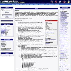
Maps can be downloaded from different map providers or rendered on-the-fly using the OpenStreetMap dataset. The maps are autoselected for best resolution depending on your position and can be downloaded from the Internet. You can choose the preferred map scale, which the program then tries to match from the available maps. Basic worldwide maps are provided and tools are included to help you add your own localized maps. Speech output is supported via the "speech dispatcher" software. Features include: GpsDrive - a free car (bike, ship, plane) navigation system - Nightly (Build 20110507043313) TangoGPS - Linux Links - The Linux Portal Site - Nightly (Build 20110507043313) TangoGPS is an open source lightweight user friendly map and GPS application.
It uses the gpsd daemon to obtain data from the GPS receiver. With gpsd, multiple GPS client applications can share access to devices without contention or loss of data. By default tangoGPS uses map data from the Openstreetmap project. Additionally a variety of other repositories can be easily added such as Maps-for-free and OpenAerialMap. The software is intended primarily for mobile devices.
Features include: Extremely fast Attractive user interface Map scale indicator Upscaling map tiles Over-zoom Distance measuring Friend finder Full screen mode Support for Points of Interest (POIs) Support for geotagged photos Send messages via tangoGPS Route tracks - fetch a route track from three different web services with two simple clicks on the map Heart rate monitoring and logging with support for Zephyr HxM heart rate monitors Keyboard shortcuts Internationalization support Return to GPS Tools Home Page.
Free user friendly map and gps for Linux. Viking - Linux Links - The Linux Portal Site - Nightly (Build 20110507043313) Viking aims to be an easy to use, yet powerful in accomplishing, a wide variety of GPS related tasks.
It uses a hierarchical layering system to organize GPS data, maps, and other layer types with spatial data, such as coordinate lines. With this software, users can import, plot and create tracks and waypoints, show OSM, Terraserver and other maps, see real-time GPS position, get geocaches, control items, etc. It is written in C with the GTK+ 2 toolkit. Features include: Uploading and downloading waypoints, tracks to/from GPS Realtime GPS tracking and track recording Preparing tracks and waypoints for trips using maps from services such as Googlemaps, Terrasever. Viking - Minefield. GCStatistic. Freeware Hex Editor XVI32.
[Overview] [Features] [What's New] [Screenshots] [User Reviews] [Download] [Installation] [Other Freeware] [Home] Overview XVI32 is a freeware hex editor running under Windows 9x/NT/2000/XP/Vista/7.
The name XVI32 is derived from XVI, the roman notation for the number 16. XVI32 and all of its components are developed by myself. The current release 2.55 is available since June 26, 2012. XVI32 is used by thousands of people all over the world. Today, XVI32 is a valuable tool for thousands of people all over the world. This app ROCKS.
This is a thread from the alt.comp.freeware newsgroup (May 2001): >>Has anyone heard of or used the freeware hex editor "XVI32 (version 2.1)"? And this e-mail was sent on October 11, 2001 by an employee of SPSS Inc., the major statistical software company: Your tool was EXACTLY what me and a friend needed to reformat huge text files correctly. You can read even more feedbacks or this nice story. Features XVI32 has the following main features. Screenshots. EasyGPS.