
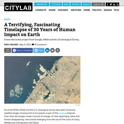
How containerization shaped the modern world - Sir Harold. Terrifying maps reveal destruction a nuclear fallout would cause to Europe's ... The image of the atomic bomb and accompanying devastation in Hiroshima is seared into many people's minds.
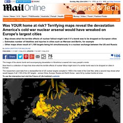
Now there's a collection of maps that show what the terrible effects of nuclear fallout might look it if a similar bomb was to be dropped on cities in Europe. The researchers used data from a declassified list of US nuclear targets compiled in 1956 in the midst of the Cold War, while a second map shows what would happen if all 1,100 of the US' targets – across China, Europe, Russia and North Korea - were hit by nuclear bombs at once. To use the interactive tool visit the Future of Life Institute's website This map drives the point home that unprediatable local weather patterns cause the impact of a nuclear blast to be felt elsewhere.
For example, a bomb dropped in Russia affects Kazakhstan in the graphic above. The terrifying maps, showing a potential nuclear exchange between the US and Russia, were created by the Future of Life Institute (FLI) and. Jordens befolkningstillväxt genom tiderna. UCDP - Uppsala Conflict Data Program. India explained in 20 maps – GEOGRAPHY EDUCATION. 38 maps that explain Europe.
40 maps that explain the Middle East. Maps can be a powerful tool for understanding the world, particularly the Middle East, a place in many ways shaped by changing political borders and demographics.
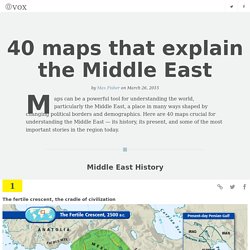
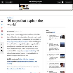
Here are 40 maps crucial for understanding the Middle East — its history, its present, and some of the most important stories in the region today. Middle East History The fertile crescent, the cradle of civilization The fertile crescent, the cradle of civilizationIf this area wasn't the birthplace of human civilization, it was at least a birthplace of human civilization. Called "the fertile crescent" because of its lush soil, the "crescent" of land mostly includes modern-day Iraq, Syria, Jordan, and Israel-Palestine. (Some definitions also include the Nile River valley in Egypt.) The Middle East today. 40 maps that explain the world. By Max Fisher By Max Fisher August 12, 2013 Maps can be a remarkably powerful tool for understanding the world and how it works, but they show only what you ask them to.
So when we saw a post sweeping the Web titled "40 maps they didn't teach you in school," one of which happens to be a WorldViews original, I thought we might be able to contribute our own collection. Repetition inför nationellt prov i geografi (SO) år 6. Africa, Uncolonized: A Detailed Look at an Alternate Continent. What if the Black Plague had killed off almost all Europeans?
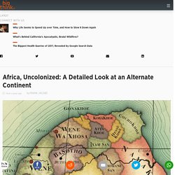
Then the Reconquista never happens. Spain and Portugal don't kickstart Europe's colonization of other continents. And this is what Africa might have looked like. The map – upside down, to skew our traditional eurocentric point of view – shows an Africa dominated by Islamic states, and native kingdoms and federations. All have at least some basis in history, linguistics or ethnography. This map is the result of an entirely different course of history. To arrive at this map, Cyon constructed an alternative timeline. Allohistorical Africa, seen from our North-up perspective. How can we graphically represent... - European Statistics.
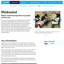
Hållbar utveckling, transport. Wind, Rain and Temperature Maps. PlayGround + - 32 years summed up in 10 seconds. A Terrifying, Fascinating Timelapse of 30 Years of Human Impact on Earth. A new interactive project from Google, NASA and the US Geological Survey.
Since the 1970s, NASA and the U.S. Geological Survey have been amassing satellite images of every inch of our planet as part of the Landsat program. Over time, the images reveal a record of change: of cities expanding, lakes and forests disappearing, new islands emerging from the sea off the coast of rising Middle East metropolises like Dubai. #?borders=1~!MTc0NTQ2MjA.MTgzODAwNA*Mjg0MTg1NTE(MTExOTE5ODk~!LB*MzEyNTQ4Mw.MT... Climate Reanalyzer. Start. Livets Lotteri - Rädda Barnen. Geologins Dag - Julkalender. Recension av Images of Changes - Vår sårbara planet.
Användningsområden.
SO-serien Geografi Lärarhandledning av Solveig Mårtensson, Lars Lindberg utgi...
Fakta om mödravård. Hög mödradödlighet 99 procent av alla de hundratusentals kvinnor som dör under graviditet och förlossning lever i låginkomstländer, varav hälften i Afrika.
Kartor, kartprojekioner och GIS. The River of Myths. Videos. HOME - Ecological Footprint - Ecological Sustaina... Global Rich List. Världskoll - Vem skulle du vara om du levde i ett annat land? Where Do You Belong? 20 Videos Exploring Geography : KQED Education. Homeland: Immigration in America/Nine Network By Sarah Bremer My students carry GPS-enabled devices (smart phones) in their back pockets and view paper maps as artifacts from a distant past.
PBS LearningMedia makes it easy for me to engage these “digital natives.” A quick search turns up high quality, targeted materials that I can easily incorporate into a lesson or homework assignment for my AP Human Geography class. The first time I used PBS LearningMedia, I simply provided my students with several links and instructed them to explore. Too often, sites with materials for teachers provide multiday lesson plans on relatively narrow topics or require paid subscriptions.
In PBS LearningMedia, educators can conduct a keyword search or browse by subject area and grade level. I. Geospatial Revolution: History of GIS GIS developed as a product of centuries of map-making and 20th-century, computer-based technology. Geospatial Revolution: Why Study GIS? Geografi.