
GIS Extension. This extension adds GIS (Geographic Information Systems) support to NetLogo.
It provides the ability to load vector GIS data (points, lines, and polygons), and raster GIS data (grids) into your model. The extension supports vector data in the form of ESRI shapefiles. The shapefile (.shp) format is the most common format for storing and exchanging vector GIS data. The extension supports raster data in the form of ESRI ASCII Grid files. NetLogo Home Page. NetLogo is a multi-agent programmable modeling environment.
It is used by tens of thousands of students, teachers and researchers worldwide. It also powers HubNet participatory simulations. It is authored by Uri Wilensky and developed at the CCL. You can download it free of charge. Your Shelf. Jim Tobias - Tucker, GA (277 books) National Atlas home page. The National Map is now offering a collection of small-scale datasets that can be downloaded for free.
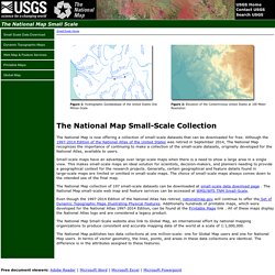
Although the 1997-2014 Edition of the National Atlas of the United States was retired in September 2014, The National Map recognizes the importance of continuing to make a collection of the small-scale datasets, originally developed for the National Atlas, available to users. Small-scale maps have an advantage over large-scale maps when there is a need to show a large area in a single view. This makes small-scale maps an ideal solution for scientists, decision-makers, and planners needing to provide a geographical context for the research projects. Generally, certain geographical and feature details found in large-scale maps are limited or omitted in small-scale maps.
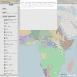
The choice of small-scale maps always comes down to the intended use of the final map. United Nations Initiative on Global Geospatial Information Management. GLOBAL SPATIAL DATA INFRASTRUCTURE ASSOCIATION. Epi Info™ - Version 7 Download. View. Welcome! - WorldMap. AfricaMap. Powered by WorldMap AfricaMap.
HIV Spatial Data Repository - Home Page. Free Spatial Data. Country level Download country level data for any country in the world: administrative boundaries, roads, railroads, altitude, land cover, population density.
Global level. World database of large urban areas, 1950-2050. LandScan Home. Using an innovative approach with Geographic Information System and Remote Sensing, ORNL's LandScan™ is the community standard for global population distribution.
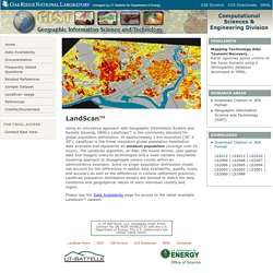
At approximately 1 km resolution (30" X 30"), LandScan is the finest resolution global population distribution data available and represents an ambient population (average over 24 hours). The LandScan algorithm, an R&D 100 Award Winner, uses spatial data and imagery analysis technologies and a multi-variable dasymetric modeling approach to disaggregate census counts within an administrative boundary. Since no single population distribution model can account for the differences in spatial data availability, quality, scale, and accuracy as well as the differences in cultural settlement practices, LandScan population distribution models are tailored to match the data conditions and geographical nature of each individual country and region.
Please see the Data Availability page for access to the latest available LandScan™ dataset. Social Explorer. Visualizations. USGS TNM 2.0 Viewer. Worldmapper: The world as you've never seen it before. International Programs - Information Gateway. Frequently Asked Questions (FAQ) 1.
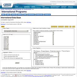
What is the International Data Base? The International Data Base (IDB) offers a variety of demographic indicators for countries and areas of the world with a population of 5,000 or more. World and Region demographic indicators in the IDB, including population totals, exclude the populations of countries and areas with fewer than 5,000 people. The IDB has provided access to demographic data for over 25 years to governments, academics, other organizations, and the public. 2. The IDB provides many types of demographic data, including: Global GIS Online Data.
Note: The icons are offered as an attempt to provide useful information about data availability and website features.
Our staff carefully surfed each website and, if available, downloaded and reviewed the retrieved data to confirm everything works fine. However, we do not have control over listed websites, and their content may change on an ongoing basis. Please contact our GIS Specialist if you have any question, identify a broken web link, or want to suggest a website to be added. WMS Services. Available WMS and WFS servers - GeoServer. World Wind. Natural Earth. GNS Home. GeoNames. Let's describe the whole world! Global Administrative Areas.
HOME. Ocean Health Index. Mapping for Results. 2.0. ZIPskinny - Get the Skinny on that ZIP (demographics by ZIP Code) Famine Early Warning Systems Network (FEWS NET) ReliefWeb. VectorMap. MosquitoMap. Home – Malaria Atlas Project. The AfriPop Project. AsiaPop. Home - GeoTech Center. GIS Commons: A Free eText about Geographic Information Systems. Spatial@ucsb - UCSB Center for Spatial Studies. Geospatial Analysis - spatial and GIS analysis techniques and GIS software. Colorbrewer: Color Advice for Maps. Dartmouth Atlas of Health Care. GEOPROJ - Home Page. MAP USA: Download. Geospatial Revolution Project. The Nature of Geographic Information. Course home page Navigation Start Here Orientation Resources Course Text Recent comments more Search Chapter 1: Data and Information Printer-friendly version ‹ GEOG 482 up 1.
Author: David DiBiase, Senior Lecturer, John A. Penn State Professional Masters Degree in GIS: Winner of the 2009 Sloan Consortium award for Most Outstanding Online Program © 2014 The Pennsylvania State University This courseware module is part of Penn State's College of Earth and Mineral Sciences' OER Initiative. The College of Earth and Mineral Sciences is committed to making its websites accessible to all users, and welcomes comments or suggestions on access improvements.
GIS Day November 14, 2012 - Discovering the World Through GIS. Postgraduate. GISCorps - Home. Home. GISCI. URISA. Esri Mapping Center. Applications Prototype Lab - Demos. Pivot for AGOL. Overview. Test/MapShaper.swf. Flex Projector. Home. YardMap. Storytelling with Maps. Global Health, Local Knowledge. Modelling, visualising, sensing and visualising urban environments.
News and Features — eBird. Sam Murray, June eBirder of the Month Please join us in congratulating Sam Murray of Augusta, GA, winner of the June 2017 eBird Challenge, sponsored by Carl Zeiss Sports Optics.
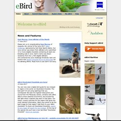
Our June winner was drawn from eBirders who submitted 15 or more eligible checklists containing at least one breeding code in June. Sam’s name was drawn randomly from the 1,769 eligible eBirders who achieved the June challenge threshold. Sam will receive new ZEISS Conquest HD 8×42 binoculars for his eBirding efforts. Read more to see Sam’s full story. eBird Illustrated Checklists are here! You can now view a digital bird guide for any hotspot or region in the world: an Illustrated Checklist. Python Programming Language – Official Website.
Welcome to the Quantum GIS Project. MapWindow Open Source GIS - Home Page. OpenJUMP GIS. uDig : Home. Processing.org. SaTScan - Software for the spatial, temporal, and space-time scan statistics. The R Project for Statistical Computing. Gapminder: Unveiling the beauty of statistics for a fact based world view. The Ghost Map by Steven Johnson.