
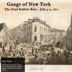
Gangs of New York. Five Points Five Points, New York in 1857 was at the intersection of Baxter Street, Worth Street and Park Street.
The Dead Rabbits Attack the Bowery Boys On the evening of July 4, 1857 members of the Dead Rabbits led a coalition of street gangs from the Five Points to raid a clubhouse at 26 The Bowery, occupied by the Dead Rabbit's rivals the Bowery Boys and the Atlantic Guards. The Bowery on a Saturday Night Paradise Square. Creating Stories from Historical Maps. Untitled. 18th Century shipping mapped using 21st Century technology. Last month we looked at an example of an old mapping style being applied to modern data.
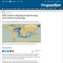
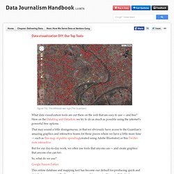
This time it's the other way round. James Cheshire, of Spatial Analysis, has taken historical records of shipping routes between 1750 and 1800 and plotted them using modern mapping tools. The first map, above, shows journeys made by British ships. Cross-Atlantic shipping lanes were among the busiest, but the number of vessels traveling to what was than called the East Indies - now India and South-East Asia - also stands out when compared to Dutch and Spanish records (see below).
If you look carefully you can also make out Captain Cook's voyages, including his two global circumnavigations. This second map shows the same data for Dutch boats. You can also see the scattering of journeys made by Dutch ships to Svalbard, off the North coast of the Norwegian mainland. The third map shows Spanish shipping routes, and immediately stands out from the other two.
Leaflet - a JavaScript library for mobile-friendly maps. An open platform. When you hear the term web map, what comes to mind first?
You might have thought of a road map – maps created to help you get from one place to another. However, there are many other types of maps that use the same mapping conventions. Examples of custom web maps. Mapbox is built from open specifications to serve all types of maps, not just road maps. Open specifications solve specific problems so the solution is simple and direct. This guide runs through all the open specifications Mapbox uses. Cómo descargar imágenes de Google, Bing, etc. Crear mapas increíbles con sus datos - CartoDB. Seven Ways to Create a Storymap. If you have a story that unfolds across several places over a period of time, storymaps can provide an engaging interactive medium with which to tell the story.
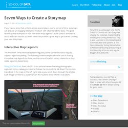
This post reviews some examples of how interactive map legends can be used to annotate a story, and then rounds up seven tools that provide a great way to get started creating your own storymaps. Interactive Map Legends The New York Times interactives team regularly come up with beautiful ways to support digital storytelling. The following three examples all mahe use of floating interactive map legends to show you the current location a story relates to as they relate a journey based story.
Riding the Silk Road, from July 2013, is a pictorial review featuring photographs captured from a railway journey that follows the route of the Silk Road. The Russia Left Behind tells the story of a 12 hour drive from St. Sounds of Street View by Amplifon. GapVis: Interfaz visual para la lectura de textos antiguos. ¿Cómo encontrar mapas antiguos Online. I first reviewed Goolzoom back in 2008, when it released a very impressive cadastre map of Spain overlaid on Google Maps.
Since then Goolzoom has quietly become a very useful GIS system built on top of the Google Maps platform. It has also been adding old paper maps to its collection all around the world. Old Maps Online. 5 sitios para encontrar mapas históricos. Autocomplete Maps Dashboard. Galería de Google Maps. Home « VII Photo. Daytripper. Google Street View Hyperlapse. World ancestry. Herramientas para crear estilos personalizados para mapas de Google Maps.
La visualización de datos DIY - Nuestras Mejores Herramientas - El Manual de Periodismo de Datos. Data visualization DIY: Our Top Tools Figure 102.
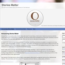
The Wikileaks war logs (The Guardian) What data visualization tools are out there on the web that are easy to use — and free? Here on the Datablog and Datastore we try to do as much as possible using the internet’s powerful free options. Automating Extracting GIS Data from Scanned Maps – GIS Lounge : Global Perspectives on Digital History. Posted on November 8, 2013 by Caitlin Dempsey he New York Public Library Labs (NYPL Labs) has posted on Github the code to its open source map-vectorizer project.
NYPL Lab’s map-vectorizer project is seeking to automate (“like OCR for maps”) the process of extracting polygon and attribute information from old scanned maps. The code was developed with the purpose of extracting building information from New York City insurance atlases published in the 19th and early 20th centuries of which the NYPL has hundreds of containing thousands of map sheets. Free open source software built by Oral Historians, for Oral Historians. Michael Frisch has recently written that the “deep dark secret” of oral history, is that we don’t really know what to do with the orality of the source.
In transcribing our interviews, we lose the orality almost immediately thus shoring the narratives of much of their meaning. This new media application now offers oral historians an alternative to transcription. On behalf of the Centre for Oral History and Digital Storytelling, I would like to announce an update to our popular oral history database called “Stories Matter.” In phase I (completed in May 2009), oral historians could download the software and build oral history databases on their local computers.
In phase II (completed in January 2010), the database allowed us to merge our local databases to an online server and therefore access them remotely. Stories matter allows us to clip, index and export audio and video recordings – and so it represents a real alternative to transcription. Snazzy Maps - Color Schemes for Google Maps. Beta version 0.9 website. Iniciación a gvSIG. Inicio — Asociación gvSIG. ORBIS. Mapas Engine Lite. Open City - Aplicaciones cívicas construidas con datos abiertos. Storytelling with Maps.
Map Tales. Bentos: Atlas Digital de aguas antiguas. Introducing Benthos AWMC is pleased to introduce a beta version of Benthos: Digital Atlas of Ancient Waters; at present this project is in its most preliminary changes, but as always AWMC welcomes feedback from the community.

Aims Benthos is a new initiative of the Ancient World Mapping Center that aims to catalog and map the waters of the ancient Mediterranean basin. As conceived, the project will incorporate physical landscape data for the ocean floor, coastlines, ports, as well as data for important rivers, estuaries, and coastal lagoons. It is also conceptually possible to incorporate digital models for both ocean current and prevailing wind patterns (e.g. the U.S.
Mapas de Go Mobile. PDF Maps is a mobile map application that enables you to download maps for offline use on your Apple iOS or Android smartphone or tablet.
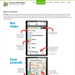
Use your device's built-in GPS to track your location on the map. Plot and record information about locations, import and export placemarks, measure distance and area, and even plot photos. You can easily browse and purchase maps from all over the world using the convenient in-app Avenza Map Store. MapAnalyst - MapAnalyst. El periodista y los mapas >> Periodismo con futuro. Una guía de recursos sobre cartografía para redactores, editores y diseñadores En febrero de 1940, casi dos años antes de que Estados Unidos entrase en la Segunda Guerra Mundial, la revista Facts in Review, uno de los principales órganos de propaganda Nazi en América, publicó un mapa que cuestionaba que Alemania fuese una nación agresora.
El mapa funcionaba como un gráfico comparativo: Alemania —diminuta— a la izquierda; a la derecha, las posesiones del Imperio Británico en la época. La revista se preguntaba por qué los alemanes, casi noventa millones, debían 'subsistir' en un territorio tan pequeño cuando los ingleses dominaban un cuarto del mundo. Indirectamente, también retrataba la supuesta relación de desventaja militar de los nazis contra su gigantesco rival. Todos los mapas mienten, pero algunos mienten más que otros. Al igual que la estadística, los mapas, cuando usados de forma descuidada, son peligrosos. TargetMap - Crear y compartir mapas de datos personalizados en Googlemaps. Herramienta gratuita de mapas en línea. Bienvenido! - Harvard WorldMap. ORBIS. Welcome - GeoServer.
Scribble Maps - Draw on google maps with scribblings and more! Neatline en Acción. We’ve prepared a number of sample Neatline exhibits to help stretch your imagination. Look below for projects in history, literature, and contemporary space and place — and come back soon to for examples of how Neatline can be used to annotate documents without reference to geography.
“My Dear Little Nelly”: Hotchkiss Maps the Battle of Fredericksburg for his Child A collection of letters written by Civil War cartographer Jedediah Hotchkiss and housed in the Small Special Collections Library at the University of Virginia includes a fascinating and unusual document. Four days after the Battle of Fredericksburg, Hotchkiss wrote a short letter to his daughter Nelly. After a describing the journey to rejoin the Confederate army and the natural surroundings of his campsite on the banks of the Rappahannock, Hotchkiss provides Nelly with a terse, understated description of the battle. GeoCommons.
GmapGIS - A web based GIS application to draw on Google maps: polygons, lines, markers and labels.