
Scale of Universe - Interactive Scale of the Universe Tool. Sites in the Valley of the Kings - Theban Mapping Project. Colonial_index. Naval Maps of World War 1 and 2, and Falklands War. Mapping America: Every City, Every Block. OpenStreetMap. Map of Chicago's Gangland, 1931. A Map of Chicago's gangland from authentic sources: designed to inculcate the most important principles of piety and virtue in young persons, and graphically portray the evils and sin of large cities, 1931.
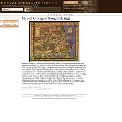
Al Capone remained part of Chicago's image long after his downfall, kept alive in popular memory by books, television, and movies, as well as by Geraldo Rivera's anticlimactic live television stunt in 1986, in which he had Capone's purported secret "vault" in the basement of the Lexington Hotel blasted open, revealing only an empty chamber. Reproductions of a lively 1931 Chicago gangland map have remained commercially available decades later. Despite the map's veneer of a pious educational purpose, its content provides vivid evidence of a degree of romance that some contemporaries attributed to the gang wars of the 1920s. Ancient-Wisdom.Co.Uk - Index of Ancient sites. Megalithic Complexes.
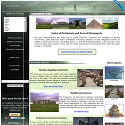
There are several well known 'concentrations' of megaliths in Europe which qualify for the title of 'megalithic complex'; Names such as the 'Boyne-valley', the 'Orkneys', 'Carnac', Malta, Silbury/Avebury and Evora in Portugal are some of the better known, but their context and relationship (if any) remains largely unknown. The initiation of such a wide-scale civil-scale constructions, being both sensitively built into the landscape, whilst incorporating a high level of similar construction skills and resulting in a common means of tracking the movements of the heavens suggests a common root. Several of these complexes have been shown to have been repeatedly re-used over and again suggesting a politically-shifting but constant cultural thread in Europe for over 2000 years.
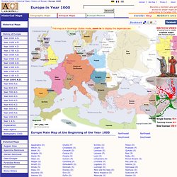
(More about Megalithic Complexes) (What Makes a Place Sacred) Complete Maps: Globes & Multi-Continent. Scans of old maps. Complete Map of Europe, Year 1000. This map is in Sovereign States mode, zoom in to display the dependencies.
- StumbleUpon. Scans of old maps from the London Geographical Institute. - StumbleUpon. Mapping America — Census Bureau 2005-9 American Community Survey. - StumbleUpon. - StumbleUpon. - StumbleUpon. Our animated maps in free access - The map as history. The first Christian communities (1st century) This map is part of a series of 17 animated maps showing History of Christianity. 4 are currently available online Independence for India and Pakistan Clement Attlee, the Labour Prime Minister who replaced Winston Churchill in July 1945, soon realised that independence for India was inevitable, but disagreements among the Indian politicians made the negotiations very difficult.
This map is part of a series of 14 animated maps showing Decolonization after 1945 The circumference of the Earth and the Route towards the West In the 3rd century BCE, Eratosthenes calculated the circumference of the Earth with remarkable precision. In later centuries, other Greek geographers, including the most famous of them all Ptolemy, suggested a much lower figure for the circumference for our planet. Old Maps Online lets you find your way around 17th century Holy Roman Empire. The world’s single largest online collection of historical maps launched earlier this week at Old Maps Online.

By the end of the year, the site aims to have 60,000 maps available for public access. Cooperating institutions include the British Library, the National Library of Scotland, the Czech Republic’s Moravian Library and the San Francisco Bay Area’s David Rumsey Map Collection. The University of Portsmouth’s Great Britain Historical Geographical Information System hosts the collection in conjunction with Switzerland’s Klokan Technologies.
Having such a large collection of cartographic history in one place and accessible by anyone with a browser is extraordinary enough. World Sunlight Map. United States Maps - Perry-Casta&eda Map Collection - UT Library Online. United States Maps The PCL Map Collection includes more than 250,000 maps, yet less than 30% of the collection is currently online.
A $5, $15, or $25 contribution will help us fund the cost of acquiring and digitizing more maps for free online access. Click the SUPPORT US button to make your contribution today! State Online Map Collections: Maps of the United States:United States nationalatlas.gov 2003 (3.0MB) [PDF format] United States CIA 2002 (200K) and PDF format (296K) United States CIA 2001 (226K) United States CIA 1999 (159K) United States CIA 1997 (527K) United States CIA 2001 2001 (750K) [PDF format] United States CIA 1999 [PDF format] 1999 (645K) United States (Outline Map) 1998 (75K) United States (Outline Map for Printing) 1998 (75K) United States including Alaska and Hawaii (Outline Map) U.S.
Language communities of Twitter. - StumbleUpon. 15 Really Odd Geographical Facts. America's Poor: A Regional Look at Poverty In America. Personal Finance News & Advice - StumbleUpon. Which are the world’s most expensive cities?
The cities included on this interactive map are from a 2009 study by the UBS, which tracked the ups and downs of various places in the wake of the financial crisis. Many cities have changed ranks, with some cities become more, and others becoming less expensive. Currency devaluations played a a major role in the change of rankings, specifically in regards to emerging market cities. High inflation rates also were a factor, especially in areas such as Caracas, Venezuela (30% per year, for the last three years) When a cursor is placed over each highlighted city, an information window will pop up, showing whether it has become more or less expensive to live in this city than it was last year, as well as last year’s rankings for that city.
Embed the above image on your site <embed width="500" height="350" src=" type="application/x-shockwave-flash"/><br /><a href=" – Mint.com. Welcome to Strangeusa.com! - StumbleUpon. Mapping History. These maps tell strange and fascinating tales. Look closely and you’ll find imagined lands, Queen’s tantrums, utopias and children’s puzzles. You’ll see Adam and Eve, a moon maiden, a symbolic knight, and wealthy show-offs. You’ll also discover the secrets of military campaigns, and read of urban rioters and scheming prisoners. You may think of maps as realistic, factual illustrations. While some maps deliberately set out to deceive, others simply show a selective view and reflect only the interests of the people who made them.
Mapping ideas Explore the way that maps have helped to spread ideas and to create new thoughts. Christian knight world map, c.1596. International Map of the World - Perry-Casta&eda Map Collection - UT Library Online. Live Ships Map - AIS - Vessel Traffic and Positions. Historical Maps - Perry-Casta&eda Map Collection - UT Library Online. Support Your Libraries My Account Home > Finding Information > PCL Map Collection > Historical MapsMaps FAQ.

- StumbleUpon. Map Collection Digital Maps - Harvard College Library - StumbleUpon. The Harvard Map Collection is one of the oldest and largest collections of cartographic materials in the United States with over 500,000 items.
Resources range from 16th century globes to modern maps and geographic information systems (GIS) layers. A selection of our materials has been digitally imaged and is offered both as true picture images and georeferenced copies. This Virtual Collection includes those maps and atlases that are available through the Harvard Image Delivery Service. Those maps that have been georeferenced are available through the Harvard Geospatial Library. Therefore, many of the maps listed will have two records, one for the image that is true to the original and the other a georeferenced image.
Only a small portion of the Map Collection has been cataloged and included in the HOLLIS catalog and an even smaller selection are included in this virtual collection as digital images. - StumbleUpon. Color Landform Atlas of the United States. Map users Across the US - 2005Tim Thompson's journal of his bicycle trip across the U.S.
Satellite tracking of eaglesFour immature Bald Eagles are being tracked using satellites. Their positions are displayed on various kinds of maps including shaded relief maps. Visit the web site to see where they are. - StumbleUpon. Wildernet - Hiking, Camping, Fishing and Many Other Activities Throughout Americas Public Lands - StumbleUpon.
Wanderlust: GOOD traces the most famous trips in history - StumbleUpon. Geosense: an online world geography game - StumbleUpon. ACME Mapper 2.0. Atlas - Fresh Logic Studios.
50 of the Most Important Landmarks of the World (Part 1) - StumbleUpon. Map Collections Home Page. Maps - StumbleUpon. Home page Down to: 6th to 15th Centuries | 16th and 19th Centuries | 1901 to World War Two | 1946 to 21st Century The Ancient World ... index of places.

Library of Congress Geography and Maps: AnIllustrated Guide. Antique Maps, Old maps, Vintage Maps, Antique Atlases, Old Atlases - StumbleUpon. Countries of the World - CountryReports.org - StumbleUpon. State and County QuickFacts. Stats about all US cities - real estate, relocation info, house prices, home value estimator, recent sales, cost of living, crime, race, income, photos, education, maps, weather, houses, schools, neighborhoods, and more.
Meaning of Place Names: Why do we call places by certain names? Behind every name is a story, and this goes for place names too. Although each individual place has a unique specific definition, there are some common components and terms for the names of English-speaking cities, towns and settlements. Knowing the meaning of these recurrent, generic root components can help you decipher the original meanings of place names. Here follows a small dictionary of place names, or more specifically, of their components: Place names based on surrounding hills, mountains and valleys: Many places are named after nearby land features such as hills and valleys: HILLS: Synonyms for hills include: Berg Usually found at the end of a place name, “berg” means hill or mountain, and is derived from Germanic origins.
In some cases “berg” has evolved into berry, bury, and borough, although usually these are derived from a different root, “burg”, which has another meaning as will be discussed below. Bryn or Vern How or Howe Tel Don or Dun.