
Britain's first geological map. Fabio Colonna nature prints. A monumental manuscript in two volumes in the hand of Fabio Colonna (1567–1640), constituting a herbal produced using a process known today as nature printing.
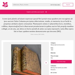
Lucia Tongiorgi Tomasi in 'An Oak Spring Herbaria' (Oak Spring Garden Library, 2009) writes of nature printing and of Colonna's manuscripts: 'This complex technique involved sprinkling a plant, either freshly picked or dried, with organic pigments and then making a direct impression of it on a sheet of paper. Multivariate Map Collection. There are many types of maps that are used to display data.
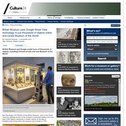
Choropleths and Cartograms provide two great examples. Search Results: Subject equal to 'Data visualization' - David Rumsey Historical Map Collection. Human Landscapes of Mexico - The Atlantic. American Panorama. British Museum uses Google Street View technology to put thousands of objects online and curate Museum of the World. The world will be able to tour the British Museum online thanks to a new alliance between curators and Google© British Museum Neil MacGregor, the Director of the British Museum, says a new Street View tour allowing access to the museum’s permanent gallery and more than 4,500 objects represents a modern version of the age of Enlightenment during which the museum was founded in 1753.
LandMark. Resources and Ideas for Making Maps. Opening ArcMap. Esri Data & Maps. ArcGIS ArcGIS Sign In Sign Out Esri Data & Maps ●Share This group provides access to data layers from the Esri Data and Maps DVD set that you can download for use with your ArcGIS software.
iOIaAJN.png (PNG Image, 4764 × 1288 pixels) - Scaled (21%)
The USGS Store - One stop shop for all your maps, world, United States, state, wall decor, historic, planetary, topographic, trail, hiking, foreign, satellite, digital. USGS Maps : Free Image : Download & Streaming. Importing Spreadsheets into Google Maps. Import info to your map - My Maps Help. You can pull lots of geographical info into a map all at once.
Here's how: Step 1: Prepare your data You can import a CSV, TSV, KML, KMZ, GPX, or XLSX file, or a sheet from Google Drive. Note: You can import only one data file per layer, and each file can have up to 2,000 rows. Step 2: Import content Open My Maps on your computer. Places will be automatically added to the map and available in a list in the legend on the left. Troubleshooting imports You might receive an error when trying import a file from Drive. Next steps. Home - Using GoogleMaps - CampusGuides Home at St. John's University.
How to Avoid Being Fooled by Bad Maps. Maps are big these days.
Blogs and news sites (including this one) frequently post maps and those maps often go viral—40 maps that explain the world, the favorite TV shows of each U.S. state, and so on. About. PELAGIOS stands for 'Pelagios: Enable Linked Ancient Geodata In Open Systems' - its aim is to help introduce Linked Open Data goodness into online resources that refer to places in the historic past.
Herodotus Timemap. Book 1, Ch. 1 This is the display of the inquiry of Herodotus of Halicarnassus, so that things done by man not be forgotten in time, and that great and marvelous deeds, some displayed by the Hellenes, some by the barbarians, not lose their glory, including among others what was the cause of their waging war on each other.The Persian learned men say that the Phoenicians were the cause of the dispute.
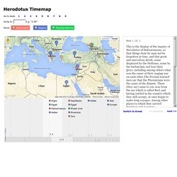
These (they say) came to our seas from the sea which is called Red, and having settled in the country which they still occupy, at once began to make long voyages. Digital Atlas of the Roman Empire. USGS Historical Topographic Map Explorer. DMMapp - Digitized Medieval Manuscripts App. What is the DMMapp?
The DMMapp is an open source app that links to digital repositories containing digitized western medieval manuscripts from all over the world. Old Maps Online. David Rumsey Historical Map Collection. Thematic Cartography Guide. Welcome!
In this short guide we share some insights and tips for making thematic maps. Our goal is to cover the important concepts in cartography and flag the important decision points in the map-making process. As with many activities in life, there isn’t always a single best answer in cartography, and in those cases we’ve tried to outline some of the pros and cons to different solutions. This is by no means a replacement for a full textbook on cartography; rather it is a quick reference guide for those moments when you’re stumped, unsure of what to do next, or unfamiliar with the terminology.
While the recommendations on these pages are short and not loaded with academic references, please appreciate that they represent a thoughtful synthesis of decades of map-making research. This guide was written by Axis Maps, adapted from documentation written for indiemapper in 2010. General Map Making Topics Univariate Thematic Map Types Multivariate Thematic Map Types. Maps Catalog. The Smithsonian Institution, since the earliest days, has sent its researchers on expeditions to fulfill the mission of increasing and diffusing knowledge. These researchers usually relied on maps to plan and guide their quests.
Efforts have been made recently to organize the maps that have accumulated over the years in the National Museum of Natural History. This website is a result of those efforts. The catalog currently includes 26575 distinct maps covering 17576 subjects, with 25278 images available for viewing. Geological Investigation of the Alluvial Valley of the Lower Mississippi River, Part IV. Fisk and his endlessly fascinating geological investigations will surely return in varying permutations, recognizably or otherwise, throughout the new year. So please visit often and stay awhile. Lower Mississippi Valley: Engineering Geology Mapping ProgramPlates 22-1 to 22-15 @ Flickr Part IIIPart IIPart I. USACE Geospatial Platform.