
Capital Toss: Capital Cities. ABCya is the leader in free educational computer games and mobile apps for kids.
The innovation of a grade school teacher, ABCya is an award-winning destination for elementary students that offers hundreds of fun, engaging learning activities. Millions of kids, parents, and teachers visit ABCya.com each month, playing over 1 billion games last year. Apple, The New York Times, USA Today, Parents Magazine and Scholastic, to name just a few, have featured ABCya’s popular educational games. Country Maps · Public Domain · PAT, the free, open source, portable atlas. Map with all Historic Places in the United States of America and Canada - HistoricPlaces.net.
World History TimeMap. The History of the USA on Google Maps. Sound maps. Cartographies of Time. World Wonders Project. Untitled. Click Below to Select a Map The Arizona Geographic Alliance and ASU’s School of Geographical Sciences have collaborated to produce the outline maps and thematic maps available here.
They are a product of communication between teachers and ASU student cartographers, guided by Alliance coordinators Gale Ekiss and Ron Dorn and cartographers Barbara Trapido-Lurie and Becky Eden. The National Geographic Society, Arizona Department of Education and National Council for Geographic Education have provided invaluable support. Old Maps Online. Geteach.com. Welcome! - WorldMap. A Free Map Quiz Game. The Collection. Where in the World? A Google Earth Puzzle - Alan Taylor - In Focus. Looking at the world via Google Earth offers striking images of the diversity of our planet and the impact that humans have on it.
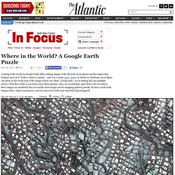
Today's entry is a puzzle -- part 2 in a series (part 1 here), in which we challenge you to figure out where in the world each of the images below was taken. (Unlike part 1, we're making this one multiple choice.) Note that north is not always up in these pictures. Also, be assured that, apart from a bit of contrast, these images are unaltered; they are exactly what Google and its mapping partners provide.