
Germany. Germany ( i/ˈdʒɜrməni/; German: Deutschland), officially the Federal Republic of Germany (German: Bundesrepublik Deutschland, pronounced [ˈbʊndəsʁepuˌbliːk ˈdɔʏtʃlant]),[7] is a federal parliamentary republic in western-central Europe.
It consists of 16 constituent states, which retain limited sovereignty, and covers an area of 357,021 square kilometres (137,847 sq mi) with a largely temperate seasonal climate. Its capital and largest city is Berlin. Germany is a major economic and political power and traditionally a leader in many cultural, theoretical and technical fields. §Etymology §History §Prehistory §Germanic tribes and Frankish Empire Second- to fifth-century migrations in Europe In the 3rd century a number of large West Germanic tribes emerged: Alemanni, Franks, Chatti, Saxons, Frisii, Sicambri, and Thuringii.
§Holy Roman Empire. Kenya. Kenya (/ˈkɛnjə/ or /ˈkiːnjə/), officially the Republic of Kenya, is a sovereign state in the African Great Lakes region of East Africa.
Its capital and largest city is Nairobi. Kenya lies on the equator with the Indian Ocean to the south-east, Tanzania to the south, Uganda to the west, South Sudan to the north-west, Ethiopia to the north and Somalia to the north-east. Kenya covers 581,309 km2 (224,445 sq mi) and has a population of about 44 million in July 2012.[7] Kenya has a warm and humid climate along its Indian Ocean coastline, with wildlife-rich savannah grasslands inland towards the capital. Nairobi has a cool climate that gets colder approaching Mount Kenya, which has three permanently snow-capped peaks. The African Great Lakes region, which Kenya is a part of, has been inhabited by humans since the Lower Paleolithic period. The capital, Nairobi, is a regional commercial hub. Etymology[edit] The Kamba people first pointed out the second mountain to Dr. Geography and climate[edit] Map Projections: Azimuthal Projections.
<br /><table class="warning" summary=""><tr><td><h2 class="warning">JavaScript Is Not Available</h2><table summary=""><tr><td><img src="../..
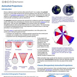
/StockImg/warning36.png" alt=""></td><td> </td><td><em>Since JavaScript is disabled or not supported in your browser, some or all maps in this page will not be displayed. </em></td></tr></table></td></tr></table><br /> Introduction Given a reference point A and two other points B and C on a surface, the azimuth from B to C is the angle formed by the minimum-distance lines AB and AC (which, on a sphere, are geodesic or great circle arcs). In other words, it represents the angle one sitting on A and looking at B must turn in order to look at C. All azimuthal projections preserve the azimuth from a reference point (the conceptual center of the map), thus presenting true direction (but not necessarily distance) to any other points. In a few two-point azimuthal projections, correct angles are presented from two specific locations instead of one.
Mercator Projection. By Matt T.
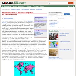
Rosenberg The Mercator projection was developed in 1569 by Gerardus Mercator as a navigation tool. Like the Peters map, the grid is rectangular and lines of latitude and longitude are all parallel. The Mercator map was designed as an aid to navigators since straight lines on the Mercator projection are loxodromes or rhumb lines -- representing lines of constant compass bearing -- perfect for "true" direction. If a navigator wishes to sail from Spain to the West Indies, all they have to do is draw a line between the two points and the navigator knows which compass direction to continually sail to reach their destination. The Mercator map has always been a poor projection for a world map yet due to its rectangular grid and shape, geographically illiterate publishers found it useful for wall maps, atlas maps, and maps in books and newspapers published by non-geographers. Mercator Projection Next page > Alternatives > Page 1, 2, 3 Articles by Date | Articles by Topic.
The Arthur H. Robinson Map Library at the University of Wisconsin-Madison. Robinson called this the orthophanic projection (which means "right appearing"), but this name never caught on.
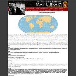
In at least one reference book, this projection is termed the Pseudocylindrical Projection with Pole Line, which is highly descriptive (the "pole line" comes from the fact that the North and South Poles on a Robinson projection are shown as lines and not points), but so unwieldily that it is not surprising that this name also failed to gain much acceptance. The "Robinson projection" is unquestionably the name of choice. The Robinson projection is highly unique. Unlike all other projections, Professor Robinson did not develop this projection by developing new geometric formulas to convert latitude and longitude coordinates from the surface of the Model of the Earth to locations on the map. Form: The Robinson projection can best be described as being pseudocylindrical, but given its unique method of development, it does not fall perfectly into any known form category.
Treasure Hunts Bonare 2006. Healthy_body.