
Our World in Data. YouTube. Country Maps From StockMapAgency.com. Fordeling af vand som ressource.docx. Fcoo.dk - ifm-maps.
Forsvarets Center for Operativ Oceanografi. – birgithallgren
Målinger af salinitet, havstrømme, bølgehøjde, tidevand mmm. – birgithallgren
Fascinating new map shows EVERY river basin on the globe with a different colour. A fascinating new colour map of the world's river systems has revealed the flowing arteries of the planet as never seen before.
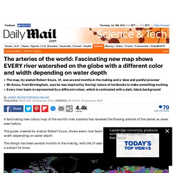
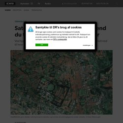
The guide, created by analyst Robert Szucs, shows every river basin on the globe with a different colour and width depending on water depth The design has been several months in the making, with the 31-year-old saying he was desperate 'to do justice' to a subject he loves. Mr Szucs has produced several national maps but has now completed his first world design (pictured). Every river basin is represented by a different colour, which is contrasted with a dark, black background This map shows the United States of America and reveals the flow of rivers across the country. The Hungarian native has no previous artistic background but says he was inspired by the 'boring nature' of textbooks. In each map every river basin is given a different colour and width depending on water depth.
He has produced several national maps but has now completed his first world design. Satellitbilleder fortæller mere, end du tror: Afslører fattige områder. Søger du information om DR's persondatapolitik Læs mere om DR's persondatapolitik (www.dr.dk/service/drs-persondatapolitik) Hvad er en cookie?
Når du besøger dr.dk eller anvender DR's apps, lagres der cookies på din computer, mobil eller tablet. En cookie er en lille tekstfil, der gemmes i din browser for at kunne genkende din computer, mobil eller tablet ved tilbagevendende besøg. Der er ingen personlige oplysninger gemt i vores cookies, og de kan ikke indeholde virus. Cookies sendes frem og tilbage mellem din browser og en webserver og indeholder bl.a. information om brugerindstillinger, login, og hvordan tjenesten benyttes. Hvis du ikke ønsker at modtage cookies, kan du blokere for alle cookies og slette eksisterende cookies fra din computer, mobil eller tablet. Hvordan undgår jeg cookies? Hvis du ikke ønsker at modtage cookies, kan du blokere for alle cookies, slette eksisterende cookies fra din computer, mobil eller tablet eller modtage en advarsel, før der gemmes cookies.
Timelapse – Google Earth Engine. Timelapse is optimized for interactive exploration on desktop browsers.
For the full interactive experience, view this page on desktop. Timelapse is a global, zoomable video that lets you see how the Earth has changed over the past 32 years. It is made from 33 cloud-free annual mosaics, one for each year from 1984 to 2016, which are made interactively explorable by Carnegie Mellon University CREATE Lab's Time Machine library, a technology for creating and viewing zoomable and pannable timelapses over space and time. Using Earth Engine, we combined over 5 million satellite images acquired over the past three decades by 5 different satellites. The majority of the images come from Landsat, a joint USGS/NASA Earth observation program that has observed the Earth since the 1970s.
Search, pan, or zoom around to begin exploring our new Timelapse, or even check out our YouTube highlights.
Erstgis. Satellitbilleder. This site uses cookies from Google to deliver its services and to analyze traffic.
Information about your use of this site is shared with Google. By using this site, you agree to its use of cookies. Learn more Got it Search this site Satellitbilleder i Undervisningen Velkommen Her finder du baggrund, data og fremgangsmåder til at bringe satellitbilleder ind i din undervisning i gymnasiet. God fornøjelse Philip Kruse Jakobsen, Silkeborg Gymnasium, Niels Vinther, Egedal Gymnasium, Jakob Kirknæs, Roskilde Katedralskole Hjemmesiden er lavet med udgangspunkt i et udviklingsprojekt støttet af Undervisningsministeriet 2014-2015.
Oversigt over materialet: E1 Almeria BAGGRUND E1 Almeria DATA E1 Almeria ØVELSE E2 Urban varmeø BAGGRUND E2 Urban varmeø DATA E2 Urban Varmeø ØVELSE E3 Havis BAGGRUND E3 Havis DATA E3 Havis ØVELSE E4 Kulminedrift i Tyskland E5 Kulminedrift i Polen E6 Geotermi på Island E7 Vesuv - hvorfor bo på en farlig vulkan? Ideer til SRP og AT Materiale om Remote Sensing OM LANDSATbilleder. Forside - GeoTema.