
Getting Googley with Geography. 10 Amazing Google Geo Tools for Your Classroom. Save Pinterest This is a guest post by Google Certified Trainer and Innovator, Stacy Behmer.
I had the privilege of attending the Google Geo Institute (#CAGTI17) with approximately 90 other educators from around the world last week to learn more about Google’s Geo Tools! I loved using maps with my students and used Google Earth, but my head was spinning with all of the ideas about how we can use the geo tools to help students learn about new places, solve problems, and tell stories!
We may not be able to physically go everywhere, but virtually the possibilities are limitless. Escape Colorado provides hand-on geography lesson - Journal Advocate. Fourth grade students at Campbell Elementary work to put together a puzzle and answer the puzzle's question to find another clue about where their missing teacher is located during an Escape Colorado activity Friday.
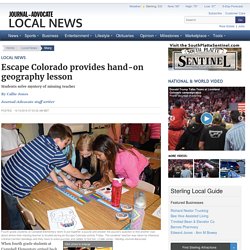
The students' teacher was taken by infamous criminal Carmen Sandiego and they have to solve puzzles and riddles to find her. (Callie Jones / Sterling Journal-Advocate) Who Actually Owns Antarctica? CGP Grey, the Internet’s Superhero Explainer of all things interesting, delves into the touchy subject of Antarctica, ownership and what happens in 2040.
Sponsored Content:Sponsored Content:Sponsored Content:Sponsored Content:Sponsored Content: Highland Middle School seventh-graders to start ‘Geocaching’ in geography class. It’s a modern version of a pirate treasure map.
But instead of gold and jewels, students participating in “geocaching” are on a quest for knowledge. Geocaching is an outdoor recreational activity, in which participants use a Global Positioning System (GPS) to hide and seek containers, called “geocaches” anywhere in the world. World's Largest Canyon Could Be Under Antarctic Ice. And you thought that gazing over the edge of the Grand Canyon was spectacular.
An analysis of satellite data has revealed what scientists believe may be an even bigger chasm–the world’s largest canyon, in fact–hidden beneath the Antarctic ice sheet. The startling finding is revealed in an article being published this month in the journal Geology, by a team that includes researchers from the UK’s Dunham and Newcastle universities and Imperial College London. Chronicling America. Students practice geography with classroom 1,000 miles away.
Geography Education News. Elephant Rock, Iceland. 10 Things You Didn’t Know About the Dead Sea. The Dead Sea, also known as the Salt Sea, is a salt lake bordering Jordan to the east and Israel and the West Bank to the west.
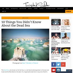
It’s a hypersaline lake that is truly one of Earth’s unique places. Below you will find ten interesting facts along with a gallery of picture of this fascinating place. All information below via Wikipedia, enjoy! 1. The surface and shores of the Dead Sea are 423 metres (1,388 ft) below sea level, making it Earth’s lowest elevation on land. Technology in the Classroom: How to Make Geography Fun. One of the hardest challenges for teachers is how to use technology in the classroom to engage students in core subjects such as geography.
It's about mountains and rocks and valleys that haven't changed for thousands of years. Why is that interesting? If you aren't a geography buff, you're probably nodding. You know what I mean. This Amazing Visualization Shows How We Got to 7 Billion People on Earth. Everything you ever wanted to know about the U.S. foreign assistance budget - Washington Post. Promoting Geography Awareness. I’m not usually one to brag, but one of my proudest accomplishments in life is winning the National Geographic Bee at my school as an eighth grader.
Although I may have peaked early, winning the bee set this once geography obsessed, nerdy middle schooler on the path to becoming an even nerdier geography obsessed adult. This lifelong passion is the reason I try to weave a range of geography themed lessons and activities into my classes. 11 Video Tutorials About Creating Multimedia Maps. 5 Map Creation Activities for Geography Awareness Week. Next week is Geography Awareness Week.
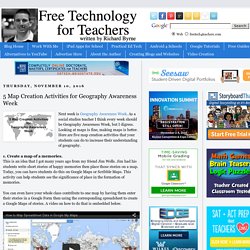
As a social studies teacher I think every week should be Geography Awareness Week, but I digress. Looking at maps is fine, making maps is better. Here are five map creation activities that your students can do to increase their understanding of geography. 1. Create a map of a memories. Geography Timeline: 13 Key Moments That Changed U.S. Boundaries. Updated February 21, 2016.
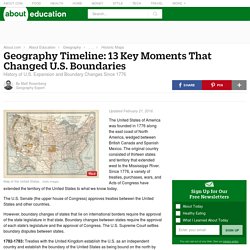
The United States of America was founded in 1776 along the east coast of North America, wedged between British Canada and Spanish Mexico. The original country consisted of thirteen states and territory that extended west to the Mississippi River. Since 1776, a variety of treaties, purchases, wars, and Acts of Congress have extended the territory of the United States to what we know today. Maps. A stunning map shows how living on America’s coasts really is so different. You probably know that New York City is an expensive place to live. But did you know that the total value of property in Manhattan is about the same as the total in Michigan? Or that the total value of property in Queens is on par with that of Louisiana? Max Galka, who runs the blog Metrocosm, has created a series of fascinating maps that show just how much wealth is locked up in the towering property values of America's coasts.
MAPS OF THE WORLD. Barefoot World Atlas App for Research and Exploration. The days of flipping through an encyclopedia and atlas are over in most classrooms. It is essential that we provide students with access to text types that are true to the digital world. One app that I absolutely love is Barefoot World Atlas from the folks at Touchpress. You might be familiar with some of their powerful iPhone and iPad apps that bring information and interactive resources to your students’ fingertips — the Barefoot World Atlas App is a great addition. Barefoot World Atlas is an interactive, digital text that includes information (and more!)
You would usually see in an atlas. Why do people mock us geography students? I’m tired of everyone giving geography students like me a hard time. For years I’ve experienced jibes, sarcastic comments and mockery for the fact I like geography, but I didn’t think it would carry on at university. My friends and I have heard all the digs, from: “where are your colouring pencils?” To “do you not get bored of looking at maps?” I don’t mock any other student’s degree, so why is geography any different? Of Hyperbole And Geography: A Map Of The World's 'Other' Capitals. To be named "world capital" of something is both a badge of honor, yet also something of a badge of shame, writer George Pendle tells NPR's Robert Siegel. It means your city revolves entirely around a single product, like gravel or toothpicks. Pendle should know: He's reported on a series of random but rather amusing list of "Other Capitals of the World" for Atlas Obscura — not the capitals of countries but of products, games and states of mind.
Here's a list of some that made us chuckle. The Toilet Paper Capital Of The World: Green Bay, Wis. 22 Maps That Show The Deepest Linguistic Conflicts In America - Business Insider. Mapping 65 Years of Explosive Urban Growth Around the World. In 1950, only 30 percent of the world’s population lived in cities, compared with 54 percent in 2015. A new map by urban geographer Duncan Smith tracks the bursts in city populations that contributed to this growth. Here’s Smith on the implication of global urbanization patterns, in a guide to his interactive data viz: Our increasingly urban world now frames many of society’s greatest challenges.
From global equality to health, education, prosperity and, not least, sustainability, solutions need to be interwoven with fostering livable, efficient and inclusive cities. Half the World Lives on 1% of Its Land, Mapped. Map creator online to make a map with multiple locations and regions.
Make Maps Online with Click2Map. Draw On Maps and Make Them Easily.