
An innovative approach to the assessment of hydro-political risk: A spatially explicit, data driven indicator of hydro-political issues. 1.1.1.
From water conflict and cooperation events to water interactions Political debate at the highest level had often expressed the concern for an increasing number of violent conflicts related to water resources use and appropriation, in particular in the cases of transboundary basins. Fao.org/documents/card/en/c/cb1447en. Pages: #210 p.
Abstract: Intensifying water constraints threaten food security and nutrition. Thus, urgent action is needed to make water use in agriculture more sustainable and equitable. Irrigated agriculture remains by far the largest user of freshwater, but scarcity of freshwater is a growing problem owing to increasing demand and competition for freshwater resources. At the same time, rainfed agriculture is facing increasing precipitation variability driven by climate change. CB1447EN. World Water Atlas. Indiens grundvand forsvinder. World Water Atlas.
Water represents society’s most challenging and complex risk.
Too much, too little, and too dirty water combine in potentially disastrous ways with climate change and socio-economic development. The High Level Panel on Water (HLPW) Action Plan points out that we need to understand the risks and link them to potential solutions to inspire action. In the summer of 2016, Prime Minister Rutte of The Kingdom of The Netherlands, when meeting with the Sherpas of the UN and World Bank’s HLPW, confirmed the urgency and need for action to better understand and address these complex risks, when he said: (1) PUMPED DRY: The Global Crisis of Vanishing Groundwater-FULL VIDEO. 195 dage uden en dråbe regn - millionby løber snart tør for vand - TV 2.
Fordeling af vand som ressource.docx. Where will the 'water wars' of the future be fought? A study finds that serious conflicts over water are going to arise around the globe.The 5 hotspots identified by the paper include areas of the Nile, Ganges-Brahmaputra, Indus, Tigris-Euphrates, and Colorado rivers.It's still possible to change course if we are prepared to address the effects of climate change.

A new paper paints a disturbing picture of a nearby future where people are fighting over access to water. These post-apocalyptic-sounding "water wars" could rise as a result of climate change and population growth and could become real soon enough if we don't take steps to prevent them. The study, which comes from the European Commission's Joint Research Centre (JRC), says that the effects of climate change will be combined with an ever-increasing number of people to trigger intense competition for increasingly scarce resources. US faces fresh water shortages due to climate change, research says. The findings of the preliminary government-backed research contrast with U.S.
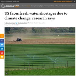
President Donald Trump's skepticism towards climate change By Sebastien Malo NEW YORK, Feb 28 (Thomson Reuters Foundation) - The pressures of climate change and population growth could cause water shortages in most of the United States, preliminary government-backed research said on Thursday. Kort over Danmark. Center for Sustainability and the Global Environment. This site contains a compilation of monthly mean river discharge data for over 3500 sites worldwide. The data sources are RivDis2.0, the United States Geological Survey, Brazilian National Department of Water and Electrical Energy, and HYDAT-Environment Canada. The period of record for each station is variable, from 3 years to greater than 100.
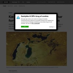
BfG - The GRDC - Global Runoff Database. GIS Vandbalance undersøgelse. GIS Problemer med vandforvaltning. Kæmpe sø er tømt: Mennesker har forvandlet den til livsfarlig ørken. Søger du information om DR's persondatapolitik Læs mere om DR's persondatapolitik (www.dr.dk/service/drs-persondatapolitik) Hvad er en cookie?
Når du besøger dr.dk eller anvender DR's apps, lagres der cookies på din computer, mobil eller tablet. En cookie er en lille tekstfil, der gemmes i din browser for at kunne genkende din computer, mobil eller tablet ved tilbagevendende besøg. How New York Gets Its Water. Water Balance App. About this App This app is based on data from NASA’s Global Land Data Assimilation System (GLDAS-2.1), which uses weather observations like temperature, humidity, and rainfall to run the Noah land surface model.

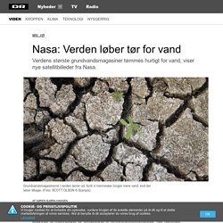
This model estimates how much of the rain becomes runoff, how much evaporates, and how much infiltrates into the soil. These output variables, calculated every three hours, are aggregated into monthly averages, giving us a record of the hydrologic cycle going all the way back to January 2000. Soil moisture plus snowpack is the water storage at any given place. Every month that storage volume changes according to the water flux - recharge occurs when precipitation is high, depletion occurs when evapotranspiration and runoff are higher. Click anywhere on the map to see how a chosen variable has changed over time, and click anywhere on the graph to switch the map to that month of interest. Hvordan får du plads til 130 liter vand i én kop? Fyld den op med kaffe. 1. En knap ressource. Nasa: Verden løber tør for vand. Millioner af mennesker er afhængige af grundvandsmagasiner, der tømmes alarmerende hurtigt.
3.verdenslande. Danmark. Vandressourcer – Københavns Universitet.