
Houdini volume passes render.
Man of Steel experiments. Infinite Horizon. Earth - Dream Koala. “INFINITY” CITIZEN x WOW. Leap, for the World Economic Forum 2014. Planet Earth in 4K. Opening scene from Contact. World Economic Forum w/ Zoë Keating. Glowy - Filter - Gizmos. Main Repository Page Gizmos Filter Must Agree to License: By downloading a file from this page you agree to the general license terms below.

Copyright (c) 2010 till presentAll rights reserved.Redistribution and use in source and binary forms, with or without modification, are permitted provided that the following conditions are met: Planet Earth seen from Space (ISS), mainly at night, with aurora borealis *Full HD* [ISS] Super Moon Seen From Space Station.
Home. Map of Rhea - November 2009. Annotated imageClick on the image for larger version This global digital map of Saturn's moon Rhea was created using data obtained by NASA's Cassini and Voyager spacecraft.
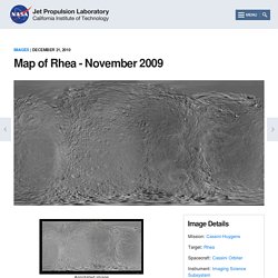
The map is an equidistant projection and has a scale of 417 meters (1,400 feet) per pixel in the full size version. Project Eden. In this post, I'll be describing in more detail how the CG Earth is constructed.
The whole planet was broken down into several key components: land, water, clouds, atmosphere and an atmospheric "rim". The atmosphere has two components because it's not a true volumetric simulation, but a kind of hack ^^; Earth_by_3DPORFTOLIO_04.jpg (JPEG Image, 5000 × 2500 pixels) - Scaled (20%) Create a Realistic Earth. Bathymetry. Bathymetry is a digital image of the undersea land surface and water depth.
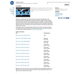
Bathymetry is the underwater equivalent of land topography. In the maps provided here, shading indicates changes in slope or depth. Much of the data on ocean bathymetry come from "soundings. " To collect a sounding, scientists use sonar devices to emit a sound wave that passes into the water. February, Blue Marble Next Generation w/ Topography. Blue Marble: Next Generation offers greater spatial detail of the surface and spans a longer data collection period than the original.
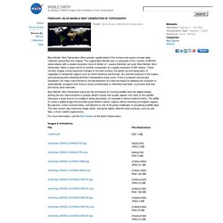
The original Blue Marble was a composite of four months of MODIS observations with a spatial resolution (level of detail) of 1 square kilometer per pixel. Blue Marble: Next Generation offers a years worth of monthly composites at a spatial resolution of 500 meters. These monthly images reveal seasonal changes to the land surface: the green-up and dying-back of vegetation in temperate regions such as North America and Europe, dry and wet seasons in the tropics, and advancing and retreating Northern Hemisphere snow cover.
Crafting the Blue Marble : Elegant Figures : Blogs. One of the best surprises of my life was turning on my brand-new iPhone—before it had even been activated—glancing down at the screen, and seeing an image I had made.
Apple chose the NASA Blue Marble for the default welcome screen and wallpaper, and I had no idea beforehand. Here’s how I did it. In 2002 my colleague Reto Stöckli (now back in Switzerland) was working on a global map of the Earth that was going to blow away all previous examples. A new NASA satellite (Terra) was gathering the first color pictures of the entire Earth, and we wanted to showcase the imagery. Reto put together about 10,000 satellite scenes (each file over 300 MB) collected over 100 days, stripped out the clouds, and created a 43,200-pixel by 21,600-pixel map of the Earth in (this was the hard part, everything I did afterwards was just adding chrome).
Now that we had a source image, we needed to create something evocative, something that would show the potential of the imagery. Made on a Mac, of course. Topography. Land topography is a digital image of the three-dimensional structure of the Earth's surface.
Shading indicates changes in slope or elevation. The relief shading in this topographic map comes mostly from elevation data collected by space-based radars. A radar in space sends a pulse of radio waves toward the earth and measures the strength and length of time it takes a signal to bounce back. From this information, scientists can determine the height and shape of the features on the surface. Topography not only gives a realistic picture of what the Earth's surface actually looks like, it also helps scientists determine things like how rivers and streams drain through the landscape, where lowlands are prone to flooding, how plate tectonics or erosion are building or wearing away mountains, where hills may be prone to landslides, or how a volcanic eruption changed the shape of a mountain. Creating the Sun in Unity3D. Time-Lapse Videos. This clickable map organizes all of the existing time-lapse sequences into geographical regions.
These videos are organized to both aid in searching for a desired area of the Earth, and to break down the volume of the existing time-lapse sequences. Each region below is separated by regions around the world, as well as links below the clickable map to the "Aurora Borealis and Australis" and "Special Videos". The newest release of time-lapse sequences will be posted just below these two sections. Due to a very active crew schedule, the current crew has been unable to take time-lapse photography. For the time being, any updates to this video site will be from past crew increments until the current crew is able to resume in this extracurricular activity.
Latest videos from the crew. Galerie de NASA Goddard Photo and Video. NOAA Satellite Reveals New Views of Earth at Night. Scientists unveiled today an unprecedented new look at our planet at night.
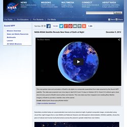
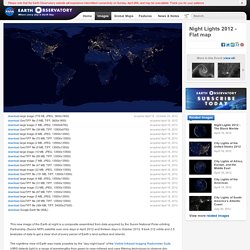
A global composite image, constructed using cloud-free night images from a new NASA and National Oceanic and Atmospheric Administration (NOAA) satellite, shows the glow of natural and human-built phenomena across the planet in greater detail than ever before. Earth at Night 2012 : Feature Articles. Night Lights 2012 - Flat map. Acquired April 18 - October 23, 2012download large image (776 KB, JPEG, 3600x1800) acquired April 18, 2012download GeoTIFF file (3 MB, TIFF, 3600x1800) acquired April 18, 2012download large image (7 MB, JPEG, 13500x6750) acquired April 18, 2012download GeoTIFF file (39 MB, TIFF, 13500x6750) acquired April 18, 2012download large image (9 MB, JPEG, 13500x13500) acquired April 18, 2012download GeoTIFF file (70 MB, TIFF, 13500x13500)
Leap, for the World Economic Forum 2014. Time-Lapse Videos. Gateway to Astronaut Photography Query Results. Earth at Night 2012 : Feature Articles. NASA-NOAA Satellite Reveals New Views of Earth at Night. Galerie de NASA Goddard Photo and Video. Galerie de AstroSamantha. Night Lights 2012 - Flat map. Dnb_land_ocean_ice.2012.13500x6750. 台風8号のヤバい画像も撮影!宇宙飛行士は最高のカメラマンだった. Browse by Collection: Blue Marble. Browse by Collection: Blue Marble. Unnamed soundsculpture - documentation. Star Guitar. Broadcast Yourself. Terrain Generation. Terrainapproaches. Houdini Projects: Terrain Generation 1. Houdini Projects: Terrain Generation 2. CG Earth render tests. 3D Visualizations - Globaïa. Wanderers - a short film by Erik Wernquist. Earth - Cinema 4d Speedrun Tutorial. Earth Tutorial for Maya.
John locke » Blog Archive » visualizing sound in processing. This was the final applet in motion. Using the minim library for processing, each waveform is generated in realtime as the two sounds play over eachother creating a pretty chaotic sound, but there are some instances of overlapping patterns where the mashup works pretty well. In the third version of the code, the boolean of the two waveforms is generated, producing a new way to visualize the waveforms. View the youtube video here, but I really need to figure out a way to add sound to the video, silence doesn’t do it justice.
Charlie Parker, Iggy Pop and Richard Wagner comparison + code: import processing.dxf.*; import ddf.minim.analysis.*; import ddf.minim.*; FFT fftLog1; FFT fftLog2; Waveform myRects; Minim minim; AudioPlayer groove1; AudioPlayer groove2; boolean record; PFont font; PFont fontoutline; void setup(){ size(1200,600,P3D); noStroke(); minim = new Minim(this); groove1 = minim.loadFile(“groove_iggy.mp3″); groove2 = minim.loadFile(“groove_wagner.mp3″); class Waveform{ float x,y,z; Kaspersky Labs Cyberthreat Real-Time Map.
Earth - Time Lapse View from Space, Fly Over - NASA, ISS. ISS at Night TimeLapse. The ISS Image Frontier - "Making the invisible visible" ISS views in HDR. The Chemical Brothers - Star Guitar. The ISS "Stacks" さくらのブログ. リクエストされたページは表示できません。 サーバのアクセス権限がありません。 [ TOPへ ] (C)Copyright SAKURA Internet Inc. リクエストされたページは表示できません。 サーバのアクセス権限がありません。 AfterEffects でモーショングラフィックを作る. この記事は2010年より前に書かれたものです。 諸々の事情で情報が正しくない可能性があります。 音の大きさ(振幅)に合わせて、素材を動かす その1. GarageBand講座からの引用ですが、音を構成する要素は以下の3つ: 音の高さ(周波数) 音の大きさ(振幅) 音色(波形) AEでは、音の大きさと素材のモーションを同期させることができます。 まずは、お手本動画で一例を紹介。 (*´ω`*)が音楽に合わせてブルブルしているのを作るつもりです。 Aftereffects チュートリアル 音楽PVに便利な小技 BGMと同期させて素材を振動|きせりのCGTV.
音のデータとAfter Effects その1 at AEP Project. LCA Creative Service. Lucy (2014) - Inspirational VFX videos. Short Film / Onedreamrush / 42 Below Vodka / China. Jeffrey Brodsky / I'll Be Strong / Music Video. One Dream Rush. View from the ISS at Night. Sundays - behind the scenes - Stardust.