
sScienceMap. List of the Egyptian Pyramids. AncientEgyptMap.jpg (JPEG Image, 841x1474 pixels) World Map 3500 BC. The map as history : a multimedia atlas of world history with animated historical maps. 10 Wonders of the World You Don’t Know. Our World While most of these wonders will be known to a few people, they are, on the whole, not as well known as the famous “seven wonders”.

Despite that, each has a reason for being considered wonderful and deserves its spot on this list. Enjoy the list and be sure to share other lesser-known wonders in the comments. Banaue Rice Terraces Philippines The Banaue Rice Terraces are 2000-year old terraces that were carved into the mountains of Ifugao in the Philippines by ancestors of the indigenous people. Sigiriya (Lion’s rock) is an ancient rock fortress and palace ruin situated in the central Matale District of Sri Lanka, surrounded by the remains of an extensive network of gardens, reservoirs, and other structures. Tower of Hercules Spain The Tower of Hercules is an ancient Roman lighthouse on a peninsula about 2.4 kilometers (1.5 miles) from the centre of A Coruña, Galicia, in north-western Spain.
Toru? Caricature Map of Europe 1914. The Clanker Powers: Germany is a massive military machine with weapons aimed outwards to all surrounding countries.
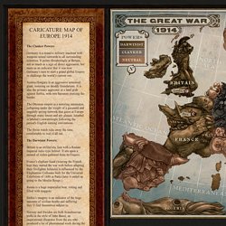
It points threateningly at Britain, not so much as a sign of direct aggression, but more as an indicator that it was now Germany’s turn to start a grand global Empire to challenge the world’s current one. Austria Hungary is an aggressive armoured giant, teetering on shoddy foundations. It is also the primary aggressor in a land grab against Serbia, with two bayonets piercing the border. The Ottoman empire is a teetering automaton, collapsing under the weight of a paranoid and ungainly spying network that gazes at Europe through many lenses and spy glasses. The Swiss watch ticks away the time, comfortable to wait it all out. The Darwinist Powers: Britain is an militaristic lion with a Roman Imperial italic-type helmet. Russia is a huge imperialist bear, rotting and filled with maggots. Portugal is a parrot for the Entente trying to goad a slumbering Spain into the war.
Visual History of War, Religion, and Government. Maps of History. Morgenthau plan. Marvelous Maps and Curious Cartography, Part Three. "QUANTUM SHOT" #817 Link - article by Simon Rose and Avi Abrams "I have an existential map.
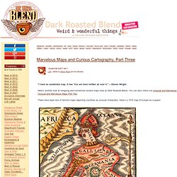
It has 'You are here' written all over it. " -- Steven Wright Here’s another look at intriguing and sometimes bizarre maps here at Dark Roasted Blend. You can also check out Unusual and Marvelous Maps and Unusual and Marvelous Maps Part Two. There have been lots of fanciful maps depicting countries as unusual characters. (image via) These caricature maps of England and Scotland appeared in the 1790s: (images credit: Yale University Library) Here’s the Korean peninsular depicted as a tiger: (left image via; on the right are antique prints via Museen Koeln) And France is shown in the form of a sailing ship: (image via) Not quite a mythical kingdom, but this map shows a part of the world that certainly proved to be nonexistent as early explorers searched for the Northwest Passage: (image via Princeton University Library) Here we have the USA with each state defined by types of beer: (images credit: Aleheads.com)
The Historical Evolution of Europe's Borders. European History Interactive Map. G. William Skinner Map Collection. Home » G.
William Skinner Map Collection G. William Skinner (1925-2008) was the dean of sinological anthropology in the West, and a major theorist of family systems and of spatial social science. He was a pioneer in applying spatial analysis techniques to the study of agrarian societies, China, Japan, and France in particular. At his death in 2008 he left a collection of over 700 maps that he and his associates created at his Spatial Systems Laboratory at the University of California, Davis, as well as over 450 rare maps from other sources. Skinner's maps are products of his lifelong interest in the spatial distribution of social variables. The maps created by Professor Skinner have a great variety of themes, from the HRS classification itself, to such demographic and economic variables as the sex ratio, fertility, and agricultural wages.
It also contains scanned images of paper maps created by Skinner and his associates. Visual History of War, Religion, and Government. Historical Maps.