
BBC Animated guides. MapMaker Interactive. Australia and South East Asia Map Puzzle. Free Map Tools. World Panoramic Photography - 360 Cities. Everest: Rivers of Ice. Global Warming Interactive. Design a habitat - ARKive Education. StatPlanet Map Maker ? Interactive Mapping & Visualization Software. Europe. Ressources Magnard en accès libre. La répartition de la population mondiale. Les grands domaines climatiques mondiaux. Climats : polaire, tempéré, chaud ou montagnard. Le relief du continent européen. Cartes interactives. Carte Interactive : régions de France. Carte Interactive : paysages français. Carte Interactive : villes françaises. Boussole et repères spatiaux. GEOGRAPHIE EN LIGNE CYCLE III.
Mathématiques Téléchargement Nommer les continents 00 Nommer les océans 00 Nommer les continents 01 Nommer les continents 02 Nommer les continents 03 Associer les grands repères Texte à trous résumé Nommer les océans 01 Nommer les océans 02 Nommer les océans 03 Situer les grandes villes du Monde Situer les grands pays du Monde Nommer les grandes villes du Monde Nommer les grands pays du Monde Le relief Les montagnes Plaines et plateaux Bassins fluviaux Retrouver les éléments du relief Savoir situer les éléments du relief Croquis de la haute montagne: vocabulaire Etagement de la végétation Des reliefs variés Les montagnes françaises Le Massif Central Le Massif Armoricain.
Liste des leçons de géographie au primaire. Mapas - Mapas Flash Interactivos. TBI et Géographie - animations FLASH - Circonscription de Gap Buech. Boussole et repères spatiaux. Les domaines climatiques ( diagrammes ombrothermiques et photo )
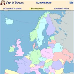
Géographie Quiz: Géographie de l'Europe. Les domaines climatiques ( diagrammes ombrothermiques et photo ) P'tit Géo en France. Tout Savoir... en s'amusant ! Hatier. Cartes interactives flash. Carte Interactive : relief européen. Les frontières de la France. Carte Interactive : relief français. Les grandes agglomérations françaises. Echos d'école - Fleuves français. Apprendre : Géographie et géopolitique. Jeux éducatifs - Géographie. Les fortes pluies saisonnières. Beautiful Earth. Virtual Volcano Fieldtrips Oregon State University. Interactive Map of Europe, Europe Map with Countries and Seas.
Europe is the second smallest of the inhabited continents.
It is a part of the Eurasian land mass that includes Europe, Asia, Asia Minor and the Arabian Peninsula. As many large islands east and south of Asia are usually included in Asia, the Eurasian land mass extends from Iceland to New Guinea, from the Atlantic to the Pacific and from the Arctic to the Indian Oceans. Just where to divide this mass into continents has long been debated. Traditionally the Ural mountains in Russia have been used as a division.
This line then had to curve back through the Caspian and Black Seas to avoid leaving Turkey in Europe. 5 Amazing Towns on Perilous Cliff Sides. Spot Cool Stuff loves a good cliff-side town.
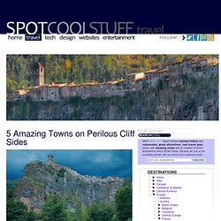
There’s something about them that’s romantic, daring and a little impossible. Here are five of our favorites places where no one with vertigo would want to live: Castellfollit de la Roca, Spain Castellfollit de la Roca, in the Catalonia region in the middle of Spain, has a doubly impressive location—this 1,000 person village is perched on a spit of land with cliffs on both sides. The village gets a steady flow of tourists during the day, which is exactly why you should spend the night here.
LEARN MORE | READ | ShareThis Manarola, Italy The uber-colorful Italian village of Manarola is not the most precariously placed cliff-side settlement of the five in this review. LEARN MORE | READ | MANAROLA B&Bs | BUY WINE ONLINE | ShareThis Al Hajjarah, Yemen. The Scale of the Universe. Dangers of Fracking. GeogSpace.