
Big Dams: Boon or Bane? The Mekong River arises in the Tibetan Plateau of southern China and descends through a series of spectacular gorges into Laos, Cambodia, and Vietnam.

The lower river widens into vast marshlands and deltas, upon which hundreds of thousands of people depend for their livelihood. Multiple dam projects, some completed, some under construction, and others planned, are dramatically changing the face of the river. The DON SAHONG DAM is under construction in Laos, just north of the Cambodian border, one of nine Mekong dams planned by the Laotian government. TweetDeck. Natural measures must be key to UK flood protection, MPs urge. Natural ways of stopping floods, such as tree planting and putting logs in rivers to slow water flow must be a key part of protecting the nation as climate change intensifies rain storms, according to a report from MPs.
The cross-party committee criticised the government for its limited plans and insufficient funding, and called for the Environment Agency to be stripped of its responsibility for flooding and replaced by a dedicated floods authority and a national flood commissioner, as is the case in the Netherlands. Other measures proposed include paying farmers to store water in fields and forcing housebuilders to make new homes resilient to flooding. More than 5 million people in England are at risk of flooding and recent winters have seen devastating deluges, with storm Desmond alone causing £5bn in damages in the northern UK.
EA Banbury 2012. River Tees: Case Study of River and Landforms by Gemma Pollard on Prezi. Swindale Beck has natural bends restored. GaugeMap. Supporting Resources. Water Cycle Water Cycle Experiment: Precipitation Water Cycle Experiment: Infiltration Water Cycle Experiment: Evaporation Water Cycle Experiment: Transpiration Water Cycle Experiment: Condensation All About Water / Water Quiz What Is A Flood?

Different Types of Flooding Activity River/Canal Flooding Animation Coastal Flooding Animation Surface Water Flooding Animation Sewer Flooding Animation Groundwater Flooding Animation Reservoir Flooding Impacts Of Flooding What Effect Would a Flood Have on You? Flooding Newspaper Headlines Activity Write a Flooding News Report Activity Create a Storm Hydrograph for a Flood Event Activity Make a Flooding Awareness Poster Activity Annual Rainfall/Impacts Activity. Banbury Flood Alleviation Scheme - 2012 on Flipboard. River Landscapes on Flipboard. 60sManagingFloodEventsHardEngineering. Module12swf. Rivers - Hydrographs. Higher Bitesize Geography - Hydrosphere : Revision. The Water Cycle Rap (with lyrics) OxbowLake. Meanders. Animation. Cleo resource: Gorge Formation. Waterfall. River Severn: Source to Mouth. Meanders are the sinuous section of the river which occur in the middle course.
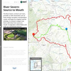
In the middle course the few features that occur are linked to the meanders, such as braiding, oxbow lakes and within the cross section of the meanders, characteristics like slip off slopes and cliffs. Meanders are caused when deposition and erosion act cooperatively. The River Severn From Source to Mouth. Animation. Cleo resource: Meander Formation. Global elevation. Innovation-681164. Flood defences officially opened. A HOST of dignitaries and officials gathered to open Banbury’s new £17 million flood defence scheme this afternoon.

Banbury MP Sir Tony Baldry, town mayor Tony Ilott and Chair of the Thames Regional Flood Defence Committee Amanda Nobbs, were among those who gathered at the site alongside the M40 to witness the unveiling of a special plaque to commemorate the event. Mr Baldry thanked the businesses and organisations who worked on the scheme and added: “If it hadn’t worked at the end of April this year we would have seen very serious flooding in Banbury, there’s no doubt about it.” He said keeping Banbury free of flood water would help release viable land for future developments in the town including the much touted Canalside scheme. Ms Nobbs told those present how the scheme - which was planned after serious flooding swamped properties and businesses in Banbury in 1998 - would help protect the town. Banbury £17m flood defences scheme opens. New £17m flood defences set up in an Oxfordshire town after a river burst its banks five years ago will officially open later.

The new flood alleviation scheme was built in Banbury after the River Cherwell flooded in 2007. It will reduce the flood risk to more than 500 properties in the town, including the railway station and football club. EA Banbury 2012. Flood Alleviation Scheme. Client: The Environment Agency Project: Banbury Flood Alleviation Scheme Location: Banbury, UK Relationship:Since 2000 The rate at which floodwater is impounded in a new storage reservoir is controlled entirely by the shape of special structures.

Many people in Banbury recall the Easter of 1998 not as a time of celebration but as a time of severe devastation. The geography of the valley along the river that runs through Banbury made the community particularly susceptible to flooding during heavy rains. The flood alleviation scheme consists of five major elements: 1) a large flood storage reservoir upstream of Banbury, 2) a key highway with raised elevation into the community, 3) new earth embankments, flood walls and pile walls in strategic locations, 4) a new pumping station and 5) a bio-habitat, complete with ponds, trees and hedgerows.
The team worked together to identify ways to reduce costs for the client and overcome challenges.