U.S. Quaternary Faults. Welcome to the U.S.
Geological Survey's interactive Quaternary faults database. This dataset is updated periodically with the latest fault information from individual states or recent publications. For more information on the recent changes please visit the ScienceBase Page U.S. Geological Survey Quaternary Faults Web Application Geologic Hazards Science Center- Earthquake Hazards Program Golden, CO.
Chapter 2: Earth Materials – The Story of Earth. The goals of this chapter are to: Identify common minerals based on physical propertiesClassify rocks based on texture and mineral compositionInterpret environments in which igneous, sedimentary, and metamorphic rocks are formedReconstruct the transport and depositional history of sedimentary rocks are the basic building blocks of rocks, which means rocks are made up of different combinations of minerals or just one mineral in some cases.
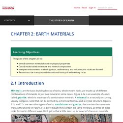
Figure 2.1a is an example of a rock called , which is made up of a combination minerals. A is a naturally occurring, usually inorganic, solid that can be defined by a chemical formula and a crystal structure. Figures 2.1b and 2.1c are two other types of rocks, and , that contain the same minerals as the granite in Figure 2.1a. According to the International Mineralogical Association, there are 5,575 known minerals, but most rocks are composed of just a few common minerals. Geological portal GeoKniga. (7) Oregon Museum of Science and Industry (OMSI) was... - Oregon Museum of Science and Industry (OMSI) How to Pack for Geology Field School - Rock Talks.
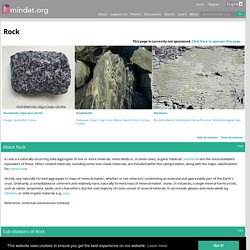
Introducing my invention: “The MultiBoard” by Obvious in Hindsight Designs. Rock: Mineral information, data and localities. A rock is a naturally-occurring solid aggregate of one or more minerals, mineraloids or, in some cases, organic material.
Sediments are the unconsolidated equivalent of these. Storytelling with maps using Tour Builder – Google Earth Outreach. Storytelling with maps using Tour Builder.
Mindat.org - Mines, Minerals and More. An Introduction to Geology – Free Textbook for College-Level Introductory Geology Courses. Written by Chris Johnson, Matthew D.
Affolter, Paul Inkenbrandt, Cam Mosher Salt Lake Community College – 2017. Fold/thrust belt on weak decollement material: Backthrusts, box folds, mushwad. Visible Geology - Stereonet - Beta Version. Geology & Tectonic Hazards - XMind.
Field Methods. Basins. 3D Block diagrams and texture mapping (using some non-free software) For this exercise we will be making a diagram using adobe illustrator (not-free) and sketchup (free).
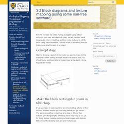
We will create a blank rectangular prism in sketchup and then make textures to add to faces using adobe illustrator. Texture is the 3D modelling term for the surface detail (image) of an object. Concept stage. Geology Cafe.com. Igneous Rock Texture Card. Turbulent flow around a wing profile, a direct numerical simulation.
Tutorial 28 Seismic Analysis. EARTHQUAKE 3D Application and Download Information Global earthquake 3d view acctivate.biz. Contents of the article California Geological Survey (CGS) staff have scoured the Internet and compiled this linked list of free-to-download, 3D paper models and paper toys that .,Historically, bushfires, floods, earthquakes, landslides and cyclones have caused loss of life and significant damage to property and infrastructure.,View maps | Open GeoScience | British Geological Survey (BGS)
Earthquake activity across Pacific. Soil Survey Manual - United States. Bureau of Plant Industry, Soils, and Agricultural Engineering - Google Books. Dana's Super-Gneiss Guide to Last-Minute Geologic Gifts. Rock Puns – Punpedia. Welcome to the Punpedia entry on rock puns!
Geology Puns – Punpedia. Welcome to the Punpedia entry on geology puns!
Petrography. Oregon Department of Geology and Mineral Industries. WATERS GeoViewer. Welcome to the WATERS GeoViewer First time users are encouraged to review the brief tutorial to become familiar with the WATERS GeoViewer’s layout and capabilities.
If you’re more adventurous, start by expanding the Operational Layers menu on the left by clicking on the arrow icon next to the Feature Layers item underneath. The Operational Layers menu is where you select which feature layers to display on the map. Note that in order to display a specific layer that all parent layers above it must also be selected. All feature layers selected for display and their symbology, can be viewed by clicking on the Legend control on the right side of the map menu bar ( ). Users are welcome to Contact Us to ask a question, provide feedback, or report a problem.
How To Become A Field Geologist In 2018 - Zippia. Mineralogy. Sed strat. Structure. Geography random. Mountains. Mr. Gruszka's Earth Science GIFtionary. Geology Coloring Book. Steven Dutch, Natural and Applied Sciences, University of Wisconsin - Green Bay First-time Visitors: Please visit Site Map and Disclaimer.
Use "Back" to return here. Visitors may copy these drawings freely for non-profit educational use. To copy the outline drawing, right-click the drawing, then either: Select File/Save As and save the drawing to your hard drive or other storage. Or.. Web pages tend to print unpredictably, so I don't recommend trying to print the whole page.
Comp apps tools/etc. Rock Slope Engineering. Dams. Fluid dynamics. Random/interesting ~ Soil. Surface processes. Physics. GSA (Geosciences) - Citing Sources and Using Style Guides - Research Guides at SUNY Geneseo. Journal Articles The most common items cited in geoscience research are journal articles. GSA citation style does not distinguish between print or online journal articles, but a DOI should be included if available. See the style guides above for information on citing books, abstracts and other information formats. Basic format: Author, A.A., Author, B.B., and Author, C.C., Year, Title of article: Titile of Journal, v. #, p. ##-##, doi: 10 Examples: GSA Manuscript Submission. Geologic Profiles The Earth can tells us its history if we only look at the clues –Types of rocks present –Ages –Formations present Sills Dikes Faults. - ppt download.
Main. Board of Geologist Examiners.
Lectures. Feild work. History. Plate Tectonics. Earthquakes. Hydrology. Rocks. Weathering/erosion/deposition.