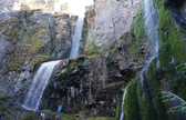
1 Shaking Ground Linking Earthquake Magnitude and Intensity How does the magnitude of an earthquake impact shaking? How does shaking impact intensity and. Www.ukm.my/rahim/Gravity method.htm. Definition.
Earthquake Hazards 201 - Technical Q&A. Engineering Geology for Society and Territory - Volume 2: Landslide Processes - Google Books. Nea6184 self sealing. Multihazard and Risk Study for Mount Hood - Background. Hazards Assets This study (DOGAMI Open-File Report O-11-16 [preview/download]) looks at volcanic, landslide, flood, channel migration, and earthquake hazards for the Mount Hood region (study area: Plate 1 [preview]).
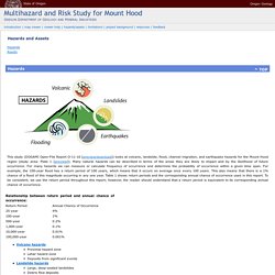
Many natural hazards can be described in terms of the areas they are likely to impact and by the likelihood of future occurrence. For many hazards we can measure or calculate frequency of occurrence and determine the probability of occurrence within a given time span. For example, the 100-year flood has a return period of 100 years, which means that it occurs on average once every 100 years.
Switzerland ShakeMap: About the Maps. Note: For more detailed information see the online ShakeMap Manual and the Publications on ShakeMap Table of Contents Introduction A ShakeMap is a representation of ground shaking produced by an earthquake.
The information it presents is different from the earthquake magnitude and epicenter that are released after an earthquake because ShakeMap focuses on the ground shaking produced by the earthquake, rather than the parameters describing the earthquake source. Seismic Wave Public Service Announcement. There are a couple of ways to measure the seismic wave, the intensity of an earthquake. 1.
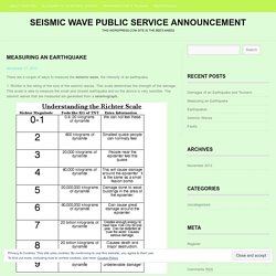
Richter is the rating of the size of the seismic waves. This scale determines the strength of the damage. This scale is able to measure the small and closest earthquake and so the device is very sensible. The seismic waves that are measured are generated from a seismograph. Estabilidad de taludes en suelos residuales. Obras y Proyectos 10, 47-61 Stability of slopes in residual soils Estabilidad de taludes en suelos residuales Laurence Wesley Department of Civil and Environmental Engineering, the University of Auckland, Private Bag 92019, Auckland, New Zealand, l.wesley@auckland.ac.nz.
National Engineering Handbook Hydrology Chapters. CHAPTER 11 - GEOLOGIC HAZARDS. The processes that have formed the earth continually act on or beneath its surface.
The movement of plates in the earth's crust and local concentrations of heat are a continuing source of hazards to people and their structures. A simplified classification of the major hazard-related geologic phenomena and the hazards they cause is presented in the box below. This chapter focuses on the use of information about earthquakes and earthquake-induced landslides, volcanic eruptions, and tsunamis (ocean waves caused by earth movement) to improve development planning in Latin America and the Caribbean. For each hazard the chapter presents physical characteristics, information sources, data available for determining the threat posed, and mitigation measures; Chapter 10 provides a more detailed discussion of landslides.
Development Planning. Geomorph_intro. Text: Bloom, Arthur, 2004, Geomorphology: Chapters 1-4 (study guide) Geomorphology From Space: Introduction: Regional Landforms Analysis and Geomorphological mapping (Optional) Definition: (Geo, G. the Earth; Morph, G.
Form, ology G. the science of) Geomorphology is the study of landscapes--It entails the systematic description of landforms and the analysis of the processes that create them. Geomorphologists are also concerned with understanding the function landforms and how landforms respond to changes in energy. Www.for.gov.bc.ca - /hfd/pubs/docs/lmh/ [To Parent Directory]
Topic: Debris Flow. Debris Flow Susceptibility Parameter Description: The susceptibility of channels to debris flow movement, scour and deposition, in terms of probability; an empirical model.
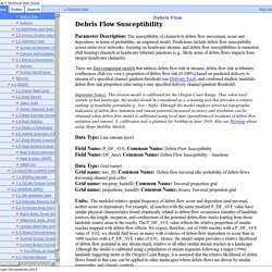
Predictions include debris flow susceptibility across entire river networks, focusing on headwater streams, and debris flow susceptibilities in mainstem (fish bearing) channels at headwater tributary junctions (e.g., likely areas of debris flows impacts from steeper headwater channels). Index of /las/physci/taylor/erth350. Upper Nehalem Watershed Council – Stewardship and understanding of the natural resources of the Upper Nehalem Watershed. Oregon Department of Geology and Mineral Industries. Oregon Geology (formerly The Ore.
-Bin) contains timely information about DOGAMI and about new and interesting developments in mining, metallurgy, and geology and is designed to reach a wide spectrum of readers in the geoscience community who are interested in all aspects of the geology of Oregon and its applications. DOGAMI is not currently accepting submissions for Oregon Geology. The magazine in its current format ceased publication with the summer 2014 issue. Landslide Hazard Rating for the Oregon Coast Range. 10 Mass Wasting – An Introduction to Geology. At the end of this chapter, students should be able to: Explain what mass wasting is and its effects on the land surface.Explain the basic processes and triggers of mass wasting.
Identify types of mass wasting. Identify risk factors for mass wasting events.Evaluate landslide risks for particular landscapes. Mass wasting is the downhill movement of rock and soil material due to gravity. The term “landslide” is often used as a synonym for mass wasting, but mass wasting is a much more broad term referring to all movement downslope. 10.1 Slope Strength Mass wasting occurs when a slope is too steep to remain stable with existing materials and conditions. In the above figure, the force vectors change as the slope angle increases. Slope Stability. Assessing and Mitigating Mass Movement Hazards As we have seen mass movement vents can be extremely hazardous and result in extensive loss of life and property. But, in most cases, areas that are prone to such hazards can be recognized with some geologic knowledge, slopes can be stabilized or avoided, and warning systems can be put in place that can minimize such hazards.
Hazard Assessment If we look at the case histories of mass movement disasters discussed above, in all cases looking at the event in hindsight shows us that conditions were present that should have told us that a hazardous condition existed prior to the event. Exploration could have revealed the sensitive clays beneath Turnagain Heights, located in known earthquake prone area. Slope stability analysis. Figure 1: Rotational failure of slope on circular slip surface Within the last decade (2003) Slope Stability Radar has been developed to remotely scan a rock slope to monitor the spatial deformation of the face.
Stability and Run-out Analysis of Earthquake-induced Landslides. Ellipse. In grid-based system, planimetric area is calculated by multiplying the number of cells times the area of an individual cell. Grid-Based Techniques for Characterizing Terrain Surface Area and Surface Line Length and Inclination By Mario Lopez, Computer Science, , mlopez@du.edu Joseph K. Berry, Geography, University of Denver, jkberry@du.edu …see select “Calculating Realistic Areas” for introductory discussion of this topic. Ellipse. The ellipse. An ellipse is one of the so-called conic sections, figures that result from slicing a right-regular cone in one of three ways. The figure below shows how that works for an ellipse.
There is only one way to form a closed figure by slicing a cone, and that's to do it without intersecting the base. If that cut is made parallel to the base we end up with a circle, which is just a special case of the ellipse. Any other such cut is an ellipse. Ellipse. Last Lecture Chemical weathering: main driver is acidic water When common rock forming minerals are weathered the typical reaction results in some loss. Calculation of Threshold Rainfall Depth for Ground Saturation. By, Erkan Istanbulluoglu Utah State University Civil & Environmental Engineering Dept. 84322-4110, Logan UT Topography plays an important role in the hydrologic response of a catchment to rainfall. 4. Measuring Vertical Angles And Slopes. Examples: 4.1 How to measure with the home-made clinometer, model 1.
How to calculate potential supply of rainwater from catchment area? - Green Clean Guide. Water is essential for the Environment, for ensuring Food Security and to ensure Sustainable Development. Determining soil infiltration rates - Minnesota Stormwater Manual. Runoff Processes: International Edition: Transmissivity Feedback. Geomorphological Research Group. Geomorphological Research Group. Sine, Cosine, Tangent. Major / minor axis of an ellipse - Math Open Reference. Area of an ellipse Calculator - High accuracy calculation. Triangle Calculator. Please provide 3 values including at least one side to the following 6 fields, and click the "Calculate" button. When radians are selected as the angle unit, it can take values such as pi/2, pi/4, etc. Calculation of the triangle - side a, b and c: a=17. b=10.8. c=25.4. Obtuse scalene triangle.
GW&P: Lesson 6 Analysis of Steady Groundwater Flow. 6.1 Steady Flow in Confined Aquifers If there is a steady movement of groundwater in a confined aquifer, there will be a linear gradient or slope to the piezometric surface; i.e., its two-directional projection is a straight line. For this type of groundwater flow, Darcy’s law can be directly applied. Darcy’s Experiments and Darcy’s Law. For the Instructor These student materials complement the Water Science and Society Instructor Materials. If you would like your students to have access to the student materials, we suggest you either point them at the Student Version which omits the framing pages with information designed for faculty (and this box).
Or you can download these pages in several formats that you can include in your course website or local Learning Managment System. Learn more about using, modifying, and sharing InTeGrate teaching materials. In 1855, Henri Darcy, a French hydraulic engineer (Figure 24), oversaw a series of experiments aimed to understand the rates of water flow through sand layers, and their relationship to pressure loss along the flow paths. Figure 24. Getting the Complete Picture: How to Best Measure a Viscosity Flow Curve. Determinants of Resistance to Flow (Poiseuille's Equation) Chapter 5. Flow Rate and Its Relation to Velocity – College Physics. Table of Contents. Chapter 3. Hydraulic Aspects in Designing Aquaculture Systems. What is volume flow rate? (article) VICAIRE - Module 3 - Chapter 4.
Elements of Physical Hydrology - George M. Hornberger, Jeffrey P. Raffensperger, PATRICIA L AUTOR WIBERG, Patricia L. Wiberg, Keith N. Eshleman - Google Books. Elements of Physical Hydrology. Groundwater Dictionary. General Facts and Concepts about Ground Water. VICAIRE - Module 3 - Chapter 4. Elements of Physical Hydrology. Digital Textbook Library. TerraGIS Soil. Pressure Loss Calculations. NGMDB Product Description Page. NGMDB Product Description Page. Soil Surveys by State. Geological Survey Water-supply Paper - Google Books. Density of Rocks and Soils. Web Soil Survey. Web Soil Survey - Home. Densities of Different Soil Types. Definition, Characteristics, & Types. Hillslope diffusion « Hindered Settling. Circumference Calculator - Omni. Semi-Ellipsoid - Geometry Calculator. Geol 247 Hillslope Lab.
Measuring Field Slopes to Estimate Soil Erosion. Geol 247 Hillslope Lab.