
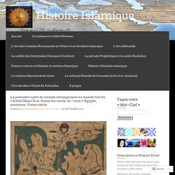
La première carte du monde rectangulaire au monde tiré du « Kitāb Gharā’ib al-funūn wa-mula’ al-‘uyūn Egypte, anonyme, 11eme siècle « «Histoire Islamique. La première carte du monde rectangulaire au monde tiré du « Kitāb Gharā’ib al-funūn wa-mula’ al-‘uyūn » Egypte, anonyme, 11eme siècle Publié le Mis à jour le Le Livre des curiosités des sciences et des merveilles pour les yeux , en arabe Kitāb Gharā’ib al-funūn wa-mula’ al-‘uyūn, est un ouvrage anonyme de cosmographie illustrée, compilé en Egypte durant la première moitié du 11e.
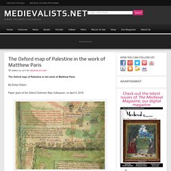
WordPress: J'aime chargement… Sur le même thème Les principaux historiens de l'histoire Islamique :Dans "Science, culture, civilisation, inventions Islamique" The Oxford map of Palestine in the work of Matthew Paris. The Oxford map of Palestine in the work of Matthew Paris By Evelyn Edson Paper given at the Oxford Outremer Map Colloquium, on April 9, 2016 The Holy Land, In Matthew Paris’s Map Of The Itinerary From London To Jerusalem – British Library Introduction: Matthew Paris, or Matthew the Parisian, born about 1200, served as the chronicler of St.
Albans Abbey from 1237 until his death in 1259. A Spy, a Map, and the Quest for Power in 16th-Century Europe. This story appears in the March/April 2017 issue of National Geographic History magazine.
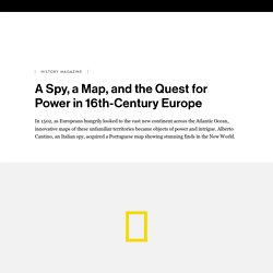
Knowledge is power—and no knowledge was more assiduously coveted by European nations in the early 16th century than the information recorded on nautical maps. Coastlines, harbors, rivers, resources: Details about these features could give a nation a distinct advantage in trying to stake a claim to new lands. The “Cantino Planisphere,” completed in 1502, is the second known chart to have depicted the New World. It included unpublished information on Portuguese trade routes and the ongoing discovery of the coastline of modern-day Brazil. At a time when knowledge of new territories lent expanding nations great strategic and commercial superiority, such maps were guarded as state secrets.
Comprising six pieces of parchment attached to a large canvas measuring about four by eight feet, the “Cantino Planisphere” was created in Lisbon. Putting It Together. Voici la carte interactive matérialisant 4000 ans de batailles. Une société néerlandaise a conçu une carte interactive mondiale mettant en évidence les lieux des batailles qui se sont déroulées pendant les quatre derniers millénaires.
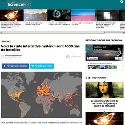
CitizenPost vous présente cette carte et propose un petit focus sur la France. Pim van Bree and Geert Kessels ont créé en 2011 l’entreprise LAB1100 basée à La Haye, aux Pays-Bas. Cette société de recherche et développement est spécialisée dans la mise au point d’outils (logiciels, applications, etc.) traitant des nouveaux médias ou ici, d’histoire. Star Wars Plot Maps Of The Original Trilogy.
Map of Star Wars A New Hope created by Andrew DeGraff The 3 Star Wars maps presented here are possibly some of the coolest and most original maps we’ve ever featured.
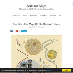
They are the brainchild of freelance illustrator and artist Andrew DeGraff. 1853 Japanese Map Of The World By Suido Nakajima. Map created by Suido Nakajima found via reddit.
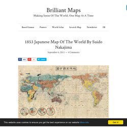
The map above is interesting not because it looks beautiful, which it does, but because of where and when it was published. 1853 (Kaei 6) was rather important year in Japanese history. It’s when the Sakoku (aka locked country) foreign policy, followed by the Japanese Tokugawa Shogunate for 250 years, was forced to come to end due to the arrival of Commodore Matthew Perry’s Black Ships in Edo (Tokyo) Bay. Between 1603 and 1853 the Tokugawa Shogunate strictly enforced a policy that almost, but not entirely, cut off Japan from the rest of the world. Japanese could not leave Japan and foreigners could only enter the island port of Dejima in Nagasaki Bay.
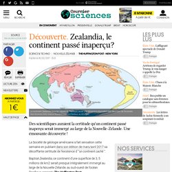
Prior to the arrival of the American sailors in Edo harbour, all Western knowledge came via the Dutch from their outpost in Dejima. Carte bathymétrique et orographique du monde, divisée en deux hémisphères, 1906. #BeautifulMaps #OldMaps. Découverte . Zealandia, le continent passé inaperçu? Des scientifiques auraient la certitude qu’un continent passé inaperçu serait immergé au large de la Nouvelle-Zélande.
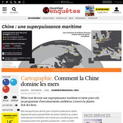
SPHAERA - BASE DE DONNÉES DE DOCUMENTS CARTOGRAPHIQUES IRD. Cartographie. Comment la Chine domine les mers. Pékin veut devenir une superpuissance maritime et mène pour cela un programme d’investissements ambitieux à travers la planète.
Etat des lieux. Une carte sonore et interactive des différentes langues du monde - Sciencesetavenir.fr. LANGUES.
Comment saluer un interlocuteur russe ou s'excuser en japonais ? Plus forcément besoin d'écumer les guides de conversation Assimil : le site web Localingual se propose de vous faire voyager linguistiquement depuis votre smartphone ou votre ordinateur. Et le tout en mettant à contribution les locuteurs de toutes nationalités, qu'ils parlent la langue officielle d'un pays (langue dite véhiculaire), ou une langue secondaire uniquement parlée par une communauté spécifique résidant dans un pays (langue dite vernaculaire).
Les visiteurs du site sont ainsi invités à enregistrer un petit extrait sonore de la langue de leur choix afin d'alimenter le projet. Accueil. The Best Maps of 2016. It’s been a good year for map lovers.
Whether you’re into old maps, new maps, or new ways of interacting with old maps, there was much to cheer about in 2016. Lots of great historical maps became more accessible this year. One of the world’s great private map collections is now open to the public at Stanford University. The Central Intelligence Agency, which isn’t exactly known for sharing, released a slew of historical maps to celebrate the 75th anniversary of its Cartography Center. Here at All Over the Map, we were excited to publish a few maps that haven’t been readily available online, including secret Japanese military maps and a map used in 1783 at the Treaty of Paris to negotiate the borders of the brand-new United States of America. It’s nearly impossible to keep up with all the innovative and beautifully designed maps being made these days. Khartis, le dernier né des outils de car...
Varsovie, #Pologne. J’en suis presque à reconnaître les villes de nuit maintenant: l’ISS, ça vous forge une culture géographique □□ #Proxima. Cartographie en cycle 3 : un blog pour trouver des pistes. La Dane (délégation académique au numérique éducatif) de l'académie de Versailles propose une plateforme permettant de créer facilement un blog pour un enseignant ou une classe. Cartographier les flux du commerce internationa... A 16th century view of North America in the Vallard Atlas. The prolific Dieppe school of Northern France produced some of the atlases with the most innovative and beautiful marginalia. The Vallard Atlas, which was made in 1547 and ascribed to the Dieppe cartography school, has a clearly Portuguese flavour due to either its anonymous creator or the model that inspired it.
Like the Miller Atlas, one of its most noteworthy characteristics are the miniatures depicting colonization scenes from the 16th century, plus countless illustrations of the daily life of the native population. The scene above shows the second American map, which is of the East Coast of North America, and is one of the most significant of the Vallard Atlas. It is again oriented to the South and has the latitude markers and distance scales in the left and right margins. In the Atlantic, almost in the center of the map, is one beautiful ship, partially surrounded by compass roses, exuding rhumb lines. An Ottoman Map of the Coastline from Rovinj North, Croatia, 16th Century (Piri Reis Haritası) De l'Antiquité à Google Maps, la cartographie miroir du pouvoir.
Inventée par les Grecs à l'Antiquité, la cartographie a subi au fil du temps nombre d'évolutions : passant d'une approche scientifique à une conception religieuse, pour finir par être définie comme une science quasi-exacte. Au delà du progrès technique et scientifique qu'elle incarne, la cartographie est aussi et surtout un outil de domination politique et militaire essentiel aux jeux de pouvoir plus que d'actualité aujourd'hui.
Old World Language Families Map. Map of Scandinavia by Nicolaus Germanius in 1467. Pangaea With Current International Borders. Map originally created by Massimo at MI LABORATORIO DE IDEAS The map above is one of my all time favourites. It shows Pangaea, a supercontinent that existed from 300 million to 175 million years ago, with modern international borders. Needless to say it would make international relations a little bit more complicated. Major changes include: The United States now borders a few new countries including Morocco, Mauritania, Senegal and Cuba. Notice anything else that might complicate international politics? To learn more about the history of the earth have a look at the following books: