
Map of Europe's Tribes (Maximum Size) Roman Roads – Sasha Trubetskoy. If you think this would make a cool poster, follow this link and send me a few bucks.
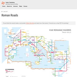
I’ll email you a crisp PDF for printing! It’s finally done. A subway-style diagram of the major Roman roads, based on the Empire of ca. 125 AD. Creating this required far more research than I had expected—there is not a single consistent source that was particularly good for this. Huge shoutout to: Stanford’s ORBIS model, The Pelagios Project, and the Antonine Itinerary (found a full PDF online but lost the url). The lines are a combination of actual, named roads (like the Via Appia or Via Militaris) as well as roads that do not have a known historic name (in which case I creatively invented some names).
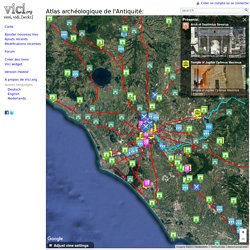
How long would it actually take to travel this network? Atlas archéologique de l'Antiquité - Vici.org. Imagery ©2017 TerraMetrics Terms of Use Report a map error Adjust view settings Présenté: Arch of Septimius Severus.
Sites et musées archéologiques gallo-romains - French ancien roman archeological sites and museum.
ORBIS carte interactive / Interactive map. 40 maps that explain the Roman Empire. By Timothy B.
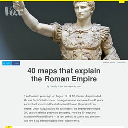
Lee on August 19, 2014 Two thousand years ago, on August 19, 14 AD, Caesar Augustus died. He was Rome's first emperor, having won a civil war more than 40 years earlier that transformed the dysfunctional Roman Republic into an empire. Quelques atlas numériques de l’Antiquité sur le Net. Le web est devenu une déclinaison évidente pour de nombreux projets scientifiques notamment ceux à caractère géographique.
La présentation et la diffusion des résultats s’en trouvent dès lors facilitées et élargies. La cartographie en ligne a suivi ce mouvement de démocratisation du savoir d’où le développement récent, dans de nombreuses disciplines, de projets ambitieux d’atlas numériques, de répertoires de lieux et de portails cartographiques à destination d’un large public. Nous vous proposons ici une sélection, non exhaustive, d’atlas archéologiques et historiques centrés, Maison de l’Orient et de la Méditerranée oblige, sur les temps anciens. Ces atlas nous ont semblé pertinents pour celles et ceux qui travaillent sur ces époques et ces problématiques.
Euratlas Shop: The Ancient Rome Vector Map. Cartes Romaine Antique. Carte empire romain. Cartes monde antique. Maps of the World @ 21 diff. periods (E.Quinn) Ancient World Mapping Center. The center supports a variety of ongoing projects including: Current Projects: Antiquity À-la-carte The Antiquity À-la-carte application is an interactive digital map of the ancient world built using open source software and data derived from The Barrington Atlas of the Greek and Roman World and Pleiades.
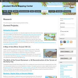
The project seeks to make an interactive, manipulable map of the ancient Mediterranean world intended primarily for students and their instructors. The application allows for an extensive range of custom criteria that can tailor the map to meet almost any needs from the archaic to the late Roman periods. A Map of Asia Minor Around 100 C.E. AWMC is compiling a single sheet scholar’s map of Asia Minor at a scale of 1:750,000 around 100 C.E. AWMC: Strabo Map. X The Strabo Application is a georeferenced, interactive digital map of the Ancient Mediterranean World to accompany the text of the Geography translated by Duane W.
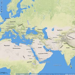
Roller and published by Cambridge University Press (2014). The application is produced by the Ancient World Mapping Center (AWMC) at The University of North Carolina, Chapel Hill, and marks all locatable settlements, features, and peoples mentioned by Strabo, as determined by the translator and presented according to his specifications. The application works best with Firefox, Chrome, or Safari. Herodotus Timemap. Book 1, Ch. 1 This is the display of the inquiry of Herodotus of Halicarnassus, so that things done by man not be forgotten in time, and that great and marvelous deeds, some displayed by the Hellenes, some by the barbarians, not lose their glory, including among others what was the cause of their waging war on each other.The Persian learned men say that the Phoenicians were the cause of the dispute.
These (they say) came to our seas from the sea which is called Red, and having settled in the country which they still occupy, at once began to make long voyages. Among other places to which they carried Egyptian and Assyrian merchandise, they came to Argos,which was at that time preeminent in every way among the people of what is now called Hellas. Empire Romain. Carte empire romain. Liste de voies romaines. Un article de Wikipédia, l'encyclopédie libre.
Cet article propose une Liste des voies romaines, classées par anciens ensembles géopolitiques de l'époque impériale : Voies romaines en Gaule[modifier | modifier le code] Omnes Viae: Tabula Peutingeriana - Itinerarium Romanum / Planificateur d'itinéraire.
Le voyage d'Ulysse (Odyssée)