
ORBIS. Historical maps. Home page Down to: 6th to 15th Centuries | 16th and 19th Centuries | 1901 to World War Two | 1946 to 21st Century.

Mémoires d'Hadrien - Entrer dans une œuvre résistante par la cartographie des lieux. Outil numérique : IGN Édugéo (offre de l’Éduthèque)Niveau : expérimentation menée en classe de 1ère générale, transposable en 2de comme en 1ère technologique.
Pourquoi l’entrée par la cartographie ? Au programme de 1ère générale depuis septembre 2019, Mémoires d’Hadrien apparaît souvent d’emblée comme une œuvre « résistante » dans laquelle il est difficile d’entrer. Face à cette œuvre érudite, où les éléments de reconstitution historique occupent une large place, l’une des premières difficultés est celle de la construction de l’univers de référence : une connaissance déjà relativement fine de la culture gréco-romaine ainsi que des différentes civilisations de l’Antiquité, notamment celles du Moyen-Orient, paraît nécessaire pour véritablement entrer dans ce roman.
Du côté des élèves, on retrouve cette difficulté posée par l’univers de référence. Ce problème est bien entendu accentué, à l’échelle du roman, par le fait que les noms des lieux ne sont souvent plus en usage de nos jours. Historic Map Works, Residential Genealogy ™ Old Maps Online. MAPCO : Map And Plan Collection Online. Download 91,000 Historic Maps from the Massive David Rumsey Map Collection.
Three years ago, we highlighted one of the most comprehensive map collections in existence, the David Rumsey Map Collection, then newly moved to Stanford University.
The Rumsey Collection, we wrote then, “contains a seemingly inexhaustible supply of cartographic images”—justifiable hyperbole, considering the amount of time it would take any one person to absorb the over 150,000 physical artifacts Rumsey has amassed in one place. By 2016, Rumsey had made almost half the collection—over 67,000 images—freely available in a digital archive that has been growing since 1996. Each entry features high-resolution scans for specialists (you can download them for free) and more manageable image sizes for enthusiasts; a wealth of data about provenance and historical context; and digital, user-friendly tools that use crowd-sourcing to measure the accuracy of antiquated maps against GPS renderings. To make this document even more compelling, it contains its own bibliography. Related Content: Atlas historique.
Atlas historique : cartographie & histoire. Histoire et géographie de l'Europe. Old-Maps - the online repository of historic maps - UK. GEOGRAPHIE ANTIQUE : cartes, textes, parcours. Public domain old world maps. Historical Kingdoms/Names. Digital Augustan Rome. The 3 Best Places To Find Free Historical Maps Online. The Internet is a great place to do research, but when it comes to finding data about the past, it’s not always the best option.
Many old records, such as maps, are not hosted in many locations. This may make you feel as if your only option is to head to the nearest big-city library and dive into their stacks, but there are a few online resources that provide a decent selection of historical maps. 40 maps that explain the Roman Empire. By Timothy B.
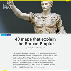
Lee on August 19, 2014 Two thousand years ago, on August 19, 14 AD, Caesar Augustus died. He was Rome's first emperor, having won a civil war more than 40 years earlier that transformed the dysfunctional Roman Republic into an empire. Under Augustus and his successors, the empire experienced 200 years of relative peace and prosperity. Digital Atlas of the Roman Empire. The Rise & Fall Of The Roman Empire: Every Year.
Map of Europe's Tribes (Maximum Size) Res Obscura: The Most Wonderful Map in the World: Urbano Monte's Planisphere of 1587. At some point in 1589, a Milanese cartographer named Urbano Monte made up his mind: his self-portrait needed updating.
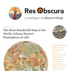
Monte carefully crouched over the section of his map that bore his self-portrait from two years earlier — close-cropped sandy hair, a trim beard, modest clothes — and pasted a new self-portrait over it. The resulting double self-portrait (Monte at 43, hidden beneath a new portrait of Monte at 45) testifies to the persistence of male pattern baldness throughout human history. It also exemplifies Monte's astonishing attention to detail. Cities that were at one point the largest in the world. The birth of Al-Andalus. American Indians Tribes Map. 40 Maps That Explain The Middle East. Maps can be a powerful tool for understanding the world, particularly the Middle East, a place in many ways shaped by changing political borders and demographics.
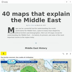
Here are 40 maps crucial for understanding the Middle East — its history, its present, and some of the most important stories in the region today. Middle East History The fertile crescent, the cradle of civilization The fertile crescent, the cradle of civilizationIf this area wasn't the birthplace of human civilization, it was at least a birthplace of human civilization.
370 - Palestine's Island Paradise, Now With a Word from its Creator. Map published on December 1945 in the American newspaper Sunday News about the land of Palestine. Animated map shows how religion spread around the world. 71 Thousand High-Res Historical Maps Available for Free Download. Visual History of War, Religion, and Government. Nuclear Detonation Timeline "1945-1998". The Liquid States of Europe. A history of global living conditions in 5 charts - Our World In Data. This is the introduction to Our World in Data – the web publication that shows how global living conditions are changing.
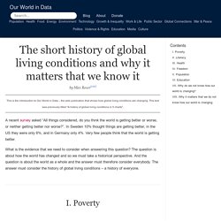
This text was previously titled "A history of global living conditions in 5 charts". A recent survey asked “All things considered, do you think the world is getting better or worse, or neither getting better nor worse?”. In Sweden 10% thought things are getting better, in the US they were only 6%, and in Germany only 4%. Very few people think that the world is getting better. What is the evidence that we need to consider when answering this question? I. To see where we are coming from we must go far back in time. 30 or even 50 years are not enough. Take a longer perspective and it becomes very clear that the world is not static at all. To avoid portraying the world in a static way – the North always much richer than the South – we have to start 200 years ago before the time when living conditions really changed dramatically. II. III. IV. V. VI. VII. VIII. Greeks and Armenians in Anatolia and Thrace, 1914 vs. Today.
Italy on the dawn of the French Revolution. - Maps on the Web. Watch as 1000 years of European borders change timelapse map. History in Motion. StoryMapJS. Maps.stamen.com. WhatWasThere - Put history in its place! Home - TimeMapper - Make Timelines and TimeMaps fast! - from the Open Knowledge Foundation Labs. Omnes Viae. Worlds Revealed: Geography & Maps at The Library Of Congress.