
Bienvenidos al sitio del CEAA. Kakapo. Catalog Page for PIA15689. This full-circle scene combines 817 images taken by the panoramic camera (Pancam) on NASA's Mars Exploration Rover Opportunity.
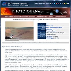
It shows the terrain that surrounded the rover while it was stationary for four months of work during its most recent Martian winter. Opportunity's Pancam took the component images between the 2,811th Martian day, or sol, of the rover's Mars surface mission (Dec. 21, 2011) and Sol 2,947 (May 8, 2012). Opportunity spent those months on a northward sloped outcrop, "Greeley Haven," which angled the rover's solar panels toward the sun low in the northern sky during southern hemisphere winter. The outcrop's informal name is a tribute to Ronald Greeley (1939-2011), who was a member of the mission team and who taught generations of planetary scientists at Arizona State University, Tempe. The site is near the northern tip of the "Cape York" segment of the western rim of Endeavour Crater.
North is at the center of the image. Top 100 Images. Psicoanálisis. NOAA Environmental Visualization Laboratory - Animations and images featuring NOAA's remotely-sensed data. MUSES : Greek Goddesses of Music, Poetry & the Arts. THE MOUSAI (Muses) were the goddesses of music, song and dance, and the source of inspiration to poets.
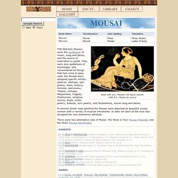
They were also goddesses of knowledge, who remembered all things that had come to pass. Later the Mousai were assigned specific artistic spheres: Kalliope, epic poetry; Kleio, history; Ourania, astronomy; Thaleia, comedy; Melpomene, tragedy; Polyhymnia, religious hymns; Erato, erotic poetry; Euterpe, lyric poetry; and Terpsikhore, choral song and dance. In ancient Greek vase painting the Mousai were depicted as beautiful young women with a variety of musical intruments. In later art each of the nine was assigned her own distinctive attribute. There were two alternative sets of Muses: the three or four Mousai Titanides and the three Mousai Apollonides. 20th Century Battlefields - Stalingrad: Part 1/6. The God Particle Vs String Theory (photobucket, converting, videos, computer) - Research, computers, social science, chemistry, biology, astronomy, physics, mathematics, AI. What has been dubbed the "God particle" is the Higgs boson, which are contained in what's called a Higgs Field which may permeate the entire universe everywhere at every point all the time.

There might be as many as 5 Higgs Fields. It has been wondered why some particles have mass and some don't. The Higgs boson seems to work out quite well as an explanation. These particles might pop in and out of existence very quickly. If indeed the Higgs boson exists, and it just might, it's been stubbornly elusive, thus the search continues to either confirm its existence or rule it out as non-existent. I thought I had posted these clips somewhere, but I'm not sure where. ‪What is a Higgs Boson? (The volume is pretty low in this video. ‪'The God Particle': The Higgs Boson‬‏ - YouTube They aren't th same.
The Higgs boson would be a result of such strings. Astronomy & Astrophysics (A&A) Zooniverse - Real Science Online. An Atlas of Cyberspaces - Network Weather Maps. Cienciorama. REDcientifica - Ciencia, Tecnología y Pensamiento. Mechanical Behavior Of Volcanic Ash Soil Typic Hapludand Under Static And Dynamic Loading. Nuevas normas en GB permiten mejor pago a donadores de gametos. Los varones podrán cobrar 56 dólares por cada visita para donar esperma y las mujeres recibirán mil 200 dólares por sus óvulos. Stone Aerospace Smart Tools, Systems, and Vehicles for Exploring and Commercializing the Frontier.
During the past six years Stone Aerospace has developed two generations of autonomous underwater vehicles and used them in a wide variety of hazardous environments from the original exploration and mapping of deep hydrothermal springs to sub-glacial lake exploration and science missions in Antarctica.
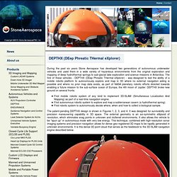
The first of these vehicles - DEPTHX (DEep Phreatic THermal eXplorer) - was designed to test the ability of a mobile robotic platform to autonomously explore and map in 3D where no external navigation aiding is possible and where no prior map data exists, as part of NASA planetary robotic efforts directed towards enabling a future mission to the sub-surface ocean of Europa, the 4th moon of Jupiter.
DEPTHX broke new ground on several fronts: First mobile robotic system of any kind to implement 3D-SLAM (Simultaneous Localization And Mapping) as part of a real-time navigation engine. First autonomous robotic system to explore and map a subterranean cavern (a hydrothermal spring). SDNHM - Yucca valida (Tree Yucca, Datilillo) El nombre genérico se refiere a un dialecto caribeño que describió por primera vez a este género.
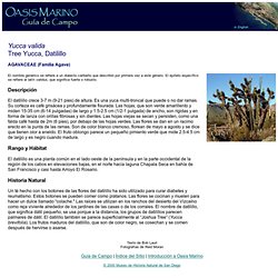
El epíteto específico se refiere al latín validus, que significa fuerte o robusto. Secretaría de Protección Civil. MINDSTORMS : Home. Códice colombino - Biblioteca Digital Mexicana - Conaculta. Se cree que este códice permaneció en posesión de los gobernantes de Tututepec, Oaxaca, desde tiempos pre-hispánicos hasta el siglo XVIII.
Tututepec es parte de la Mixteca de la Costa, en el actual estado de Oaxaca, en el sur poniente de México. Se considera el único códice pictórico prehispánico en una colección mexicana. Gato clonado por encargo. Una empresa de Estados Unidos aseguró haber vendido el primer gato clonado por encargo a partir del ADN de una mascota.

Se trata de Little Nicky, un gatito de nueve semanas que fue adquirido por una mujer en el estado de Texas por US$50.000. The syntax of natural language: An online introduction. Territorio. Porción del espacio terrestre considerada en sus relaciones con los grupos humanos que la ocupan y la ordenan con vistas a asegurar la satisfacción de sus necesidades.
Noción autónoma, el territorio en geografía no es ni un sinónimo ni un substituto del término espacio. Ciertamente, si hay espacio en el territorio, éste no es considerado como un soporte neutro ni isótropo. Múltiples componentes (medioambiental, social, económico, institucional, etc.) dan especificidad et identidad a la configuración y al funcionamiento de este conjunto. Comprender un territorio es poner en evidencia las interacciones entre sus diferentes componentes y no considerarlos como capas sucesivas cuya totalidad constituiría un conjunto denominado territorio. La ocupación humana, proyectos múltiples y capacidades variables para llevar a cabo objetivos dan forma y ordenan los territorios según escalas variables. Geology: Plate Tectonics. Science News, Articles and Information.
Secret Worlds: The Universe Within - Interactive Java Tutorial. Secret Worlds: The Universe Within View the Milky Way at 10 million light years from the Earth.
Then move through space towards the Earth in successive orders of magnitude until you reach a tall oak tree just outside the buildings of the National High Magnetic Field Laboratory in Tallahassee, Florida. After that, begin to move from the actual size of a leaf into a microscopic world that reveals leaf cell walls, the cell nucleus, chromatin, DNA and finally, into the subatomic universe of electrons and protons.
Once the tutorial has completely downloaded, a set of the arrows will appear that allow the user to increase or decrease the view magnitude in Manual mode. Click on the Auto button to return to the Automatic mode. Notice how each picture is actually an image of something that is 10 times bigger or smaller than the one preceding or following it. The Minimalist Program. Planet Earth Expanding. Published in Portland, Oregon, by Lufa Studio and in cyberspace at <www.triplehood.com> ISBN 0-9675806-0-9 1.
The Plate Tectonics Revolution--from Pebbles to Jewels Portions of tomography images, figures 15 and 16, redrawn after Grand, Van der Hilst, Widiyantoro, and Engdahl, in Nature and GSA Today, April 1997¾ please consult the originals for color and precision. The indulgences granted by colleagues, friends, and family over the years, for my espousal of a somewhat controversial scientific perspective in the Earth sciences, are acknowledged and appreciated. Southwest Missouri State University has neutrally supported my participation at the Tsukuba international symposium on New Concepts in Global Tectonics, in 1998. Untitled. Sandwalk. Deep Sea Creatures - Discover Deep Sea Creatures on Sea and Sky. Science - News for Your Neurons.
Ciencia y Sociedad. University of California, San Diego: External Relations: News & Information: News Releases : Arts & Humanities. July 19, 2005 DRAWING WITH DNA Interactive ‘Bioart’ Installation Illuminates Genomics at SIGGRAPH By Inga Kiderra On any given day, tens of thousands of biologists around the globe run DNA sequences of unknown function through a lightning-fast online algorithm called BLAST – typically submitting 200 to 400 base pairs, or “letters” of genetic code, to be matched against the billions of letters for known genes. Searching for similarities that can shed light on functional or evolutionary relationships, scientists routinely use BLAST to churn through and produce vast amounts of data.
Everyday applications include genetic medicine and pharmaceuticals. “Ecce Homology,” an interactive “bioart” installation to be showcased at SIGGRAPH 2005 – in Los Angeles, July 31 through Aug. 4 – quite literally makes BLAST and genomics visible. Vampire Squid Turns Itself "Inside Out" The Particle Zoo: Subatomic Particle plushies. MUSES - Greek Mythology Link. The violet-eyed MUSES delighted in feasts and the pleasure of song, Peace being their dearest friend. Códice Colombino. Improbable Research. GigaPan. Xah Lee Web 李杀网. Memory. 1. The Concept of Memory. Naica panorama - Google Search. La ciencia para todos.