
Integrated Water Resources Information System. MSG Data Manager. What is MSG?
Meteosat-8 (or MSG-1 as it was known during trials) is the first of the new European geostationary weather satellites. MSG is an acronym for Meteosat Second Generation. Meteosat-8 served from 2003 to 2007, and is now the standby and Rapid Scan satellite, with Meteosat-9 as the prime satellite since April 2007, and Metoesat-10 (MSG-3) since January 2013. Meteosat-8/9/10 has twelve sensor channels rather than three, higher spatial resolution, much higher visible channel resolution, better thermal accuracy, and double the frequency of image delivery than previous Meteosat satellites; all of which necessitates a change to the data transmission method.
Meteosat-10 (MSG-3) has replaced Meteosat 7, and the WEFAX and PDUS transmissions have now ceased. Please note that you will need a licence from EUMETSAT to receive some of this data, but UK amateurs should see the GEO Quarterly for more details. MODIS L1 Viewer. The MODIS L1 Viewer allows you to visualise either image or fire data from the MODIS satellites (Aqua and Terra) from the Internet or the 1km resolution data sent over the EUMETCast system (you will need to register with EUMETSAT to get this additional data, but it is free).
My MSG Data Manager program is recommended to copy the EUMETCast data into a date-named directory tree and manage the removal of older data. The MODIS data is sent in 5-minute segments, and the program allows you to combine multiple 5-minute segments from the same pass to produce a larger regional image. Both the raw data, and several derived false-colour images are available. Program Functions Browser view Raw Images display Once you have selected one or more segments for processing, the Raw Images tab is where the data is first displayed.
Right-clicking any of the images allows you to: Add boundaries. Derived Images display. Using the GeoSatSignal program. Douglas Deans' articles on geostationary weather satellites.
These articles are written by the long-time geostationary weather satellite expert, Douglas Deans, and may help put the usage of GeoSatSignal into perspective. They were written before and during the initial trials of the Meteosat Second Generation satellite (MSG-1), now Meteosat-8. Getting the data GeoSatSignal can utilise data from a variety of sources, Internet data, WEFAX images, and digital HRI data in a variety of formats such as from the Rob Alblas decoder, Dundee PDUS data and Timestep MPD files. If you want to use Internet data, I have a simple program that will help registered users of GeoSatSignal retrieve data automatically. Precipitation: OVERVIEW. Info Welcome to the Precipitation Data and Information Services Center (PDISC).
Here are some links to help you get started: Sign Up for the GES DISC Precipitation Mailing List Sign up for the GES DISC Precipitation Portal listserv to receive announcements on the latest data information, tools and services that become available, data announcements from PPS and more! Contact the GES DISC User Services to be added to the list. Global Precipitation Measurement (GPM) An international satellite mission to be launched by NASA and JAXA in 2014 that will set new standards for precipitation measurements worldwide using a network of satellites united by the GPM Core Observatory. HydroSHEDS. TRMM. APHRO_V1101_readme. TRMM. UU TRMM Dataset. University of Utah TRMM database One way to summarize the precipitation events from the TRMM dataset is to define Precipitation Features (PFs, Nesbitt et al., 2000).
This method groups the pixels with near surface PR reflectivity > 20 dBZ or ice scattering signal defined by TMI 85 GHz Polarization Corrected Temperature (PCT, Spencer et al., 1989) < 250 K. Using this definition and the similar feature grouping concept, results have included rainfall estimates validation (Nesbitt et al., 2004), diurnal cycle of precipitation systems (Nesbitt and Zipser, 2003), global distribution of storms with LIS-detected lightning (Cecil et al., 2005), deep convection reaching the tropical tropopause layer (Liu and Zipser, 2005), rainfall production and convective organization (Nesbitt et al. 2006), and the categorization of extreme thunderstorms by their intensity proxies (Zipser et al., 2006). TRMM DATA: PRIMARY STATISTICAL PARAMETERS. Page Contents: Primary Statistical Parameters Mean and variance of precipitation are two primary parameters.
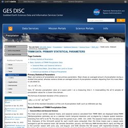
Mean shows an averaged amount of precipitation during a studied time period, whereas variance shows an averaged amount of precipitation variation departing from this mean.Mean is calculated as: Ri = S ( Rit ) / N , here, Rit denotes precipitation value at a space point i on a measuring time t. Rainfall estimates comparisons. About climate statistics. Introduction The Climate statistics for Australian locations consists of information for more than 1000 sites.
The tables prepared for each site provide averages and other statistics for a number of elements including: Further information about each of these statistics can be found by clicking on the first column of each row in the statistics tables. Sites have been included only if a minimum of 10 years of temperature data are available for the site. Thus, statistics for more than 15,000 rainfall-only stations are not currently available on this web site, but may be obtained by contacting the Bureau. Top. Finding the percentile of the values. TRMM. APHRODITE's Water Resources - Gridded Daily Precipitation by Rain Gauge. Data Cookbook. Data Cookbook. Mirador - Goddard Earth Sciences (GES) Data and Information Center (DISC)