
Fusion Tables - Gather, visualize, share tables online. Bust your data out of its silo!

Get more from data with Fusion Tables. Fusion Tables is an experimental data visualization web application to gather, visualize, and share data tables. Visualize bigger table data online Filter and summarize across hundreds of thousands of rows. Then try a chart, map, network graph, or custom layout and embed or share it. Two tables are better than one! Merge two or three tables to generate a single visualization that includes both sets of data. Make a map in minutes Host data online - and stay in control Viewers located anywhere can produce charts or maps from it.
Visualize bigger table data online Import your own data Upload data tables from spreadsheets or CSV files, even KML. Visualize it instantly See the data on a map or as a chart immediately. Publish your visualization on other web properties Now that you've got that nice map or chart of your data, you can embed it in a web page or blog post. Two tables are better than one! Crowdmap. Far From the Madding Crowd Map.
Far From the Madding Crowd Map created by Peter Biggins ^^^ Hide Description ^^^ Advertisements Categorized Markers Author Book view locations on separate page.

Data visualization software & Data Presentation Software - InstantAtlas. My Fusion Tables. Crowdmap. Crowdmap Basics - Creating a Deployment. Ushahidi's Channel. Radius Around a Point on a Map. You can use this tool to find the radius around a point on the map.
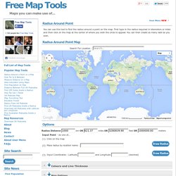
First type in the radius required in kilometers or miles and then click on the map at the center of where you wish the circle to appear. You can then create as many radii as you wish. Options Radius Distance km OR miles OR feet OR meters Instructions Type in a radius required in the text box above. Use the "URL to last radius" text box to find a URL that will show the most recent radius on this page when opened in a web browser. Google Earth KML Output You can now export all the drawn radii on the map to Google Earth for improved display and printing. The procedure to Export to KML is as follows: Draw one or more radii on the map as you see fitOnce ready, click the [Generate KML] button. Currently, the KML will include: The same radius size and shapeTransparency of 50% It will not include: These features may be added later depending on feedback. CSV Upload The CSV option allows you to upload bulk points to the map. For Example...
Rapid mashup development tool to build custom Google and Yahoo maps! MapAList - Create and Manage Maps of Address Lists. Interactive map: iMapBuilder map software. Create editable interactive maps, flash map and clickable image maps. Создавайте карты Google для многих адресов/координат. MAPme.com - Map your World! Free Embeddable Maps. Map Maker. Google Map Maker officially closed on March 31, 2017, and many of its features are being integrated into Google Maps.
Since 2008, the Google Map Maker community has edited and moderated millions of features to improve the Google Maps experience. To make it easier for all Google Maps users to contribute changes to the map, we’ve started to graduate functionality from Map Maker to Google Maps on both desktop and mobile. Key editing features currently available in Google Maps include: We’ll continue to add new editing features within Google Maps on an ongoing basis. To keep contributing your local knowledge to Google Maps and engage with a passionate community of likeminded individuals, we invite you to join the Local Guides program where you can do things like: Earn points Unlock rewards for submitting edits and other information Get early access to new Google Map features. GoogleMapMaker's Channel. Make Maps Online with Click2Map. StepMap - Create your personal map for free. Create your own map, build interactive maps, place photos, videos on a map.
Interactive flash maps. StatPlanet - Interactive Maps of World Stats. Interactive maps and visualizations. FAQ. For general support documentation and user guides, please see the Resources section, and the Forum for any questions or comments.
Custom maps / GIS: Can I create my own maps for StatPlanet? Yes, that is possible. There are two kinds of 'custom' maps that can be inserted into StatPlanet - Flash Maps and Shapefile Maps. Shapefile maps are readily available maps which normally do not require (much) modification. Flash Maps are designed and therefore any features you require can be included in the design. How do I import ESRI shapefile maps (SHP) into StatPlanet? Yes, StatPlanet Lite and StatPlanet Plus have support for loading GIS / ESRI shapefiles. Where can I find free maps to use in StatPlanet Plus? Please see the free shapefile map downloads page to find shapefile maps which can be used in StatPlanet Plus (Shapefile edition). How do I add countries, regions, cities or other areas to my map? StatPlanet Plus only: Yes you can export the map as a vector image in the PDF format. Data: 1. 2.