Collections & research. Our collection consists of over 200,000 maps, atlases, globes, and related materials.
But more than that, it is an archive of our world’s landscapes and environments as well as human cultures, myths, arts, and scientific developments. We are dedicated to digitizing our collection and providing it online. While digital copies allow for wide access, we also believe that there is nothing that compares to seeing an historic map in person. We welcome visitors to the Center to spend time with an old map. Come research, learn, reflect, be challenged, see something beautiful, or engage with a document much older than yourself. Additionally, the Branner Earth Sciences Library & Map Collections at Stanford houses maps from the 1920s to the present. Index. Historischer Atlas von Baden-Württemberg - LEO-BW. Prevnext Web Content Anzeige Gliederung nach oben Allgemein.
Histoire à la carte, le premier atlas historique multimédia. The Historical Atlas of Europe. Atlas des Deutschen Reichs. The map below, reproduced from the original title page, depicts the area covered by the Atlas des Deutschen Reichs, and shows the division of the entire area into the nine main maps and two smaller maps of the original atlas.
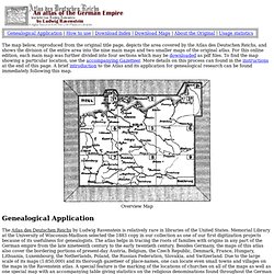
For this online edition, each main map was further divided into four sections which may be downloaded as pdf files. To find the map showing a particular location, use the accompanying Gazetteer. More details on this process can found in the instructions at the end of this page. A brief introduction to the Atlas and its application for genealogical research can be found immediately following this map. Overview Map Genealogical Application The Atlas des Deutschen Reichs by Ludwig Ravenstein is relatively rare in libraries of the United States. SLUB Dresden: Sachsen.digital: Historische Karten. Karten. IEG-MAPS. Staatsbibliothek zu Berlin / IKAR: ikar.sbb.spk-berlin.de.
Projektgeschichte: Im Jahre 1985 wurde auf Initiative der Deutschen Forschungsgemeinschaft (DFG) und der drei größten Kartensammlungen in deutschen Bibliotheken, der Bayerischen Staatsbibliothek München, der Niedersächsischen Staats- und Universitätsbibliothek Göttingen und der Staatsbibliothek zu Berlin mit dem überregionalen Katalogisierungsprojekt „Erschließung historisch wertvoller Kartenbestände bis 1850" begonnen.
Nach der Offline-Erfassung der Karten in verschiedenen Datenpools während der ersten fünf Jahre erfolgte im Herbst 1991 der Aufbau eines gemeinsamen Online-Katalogisierungssystems (IKAR) durch das Deutsche Bibliotheksinstitut (DBI) in Berlin. Im Jahr 2000 wurde die Altkartendatenbank in den Gemeinsamen Bibliotheksverbund (GBV) überführt, wo sie jetzt allen Interessenten für Recherchen im Internet zur Verfügung steht sowie weiteren Kartensammlungen die Teilnahme an der Katalogisierung ihrer Altkarten ermöglicht.
Wiegand, Günther: Wegweisung in eine vergangene Welt. ATLAS HISTORIQUE - Cartographie & histoire. DIGMAP. Perry-Castañeda Library Map Collection - UT Library Online. Cartomundi. La participation à l'annuaire de CartoMundi est ouverte à tous les établissements qui conservent, commercialisent ou produisent des documents cartographiques.
Ses données sont publiques, elles sont accessibles en ligne à travers le portail des cartothèques. Cette participation est gratuite, les partenaires peuvent se retirer de l'annuaire à n’importe quel moment. Pour devenir partenaire, la procédure est la suivante : 1. Demander la création d’un compte * Cocher les cases « Accepter ces conditions » et « Demande d’inscription », en bas de cet écran. * Remplir le formulaire « Demande de partenariat » puis l’envoyer en cliquant le bouton « Soumettre » Cette étape prend seulement quelques minutes. The map as history : a multimedia atlas of world history with animated historical maps.
Visual History of War, Religion, and Government. Old Maps Online. European History Interactive Map. Old-Maps - the online repository of historic maps - home page. IEG-MAPS. Map Collections Home Page. The Library of Congress Search by Keyword | Browse by Geographic Location Index | Subject Index | Creator Index | Title Index The Geography and Map Division of the Library of Congress holds more than 4.5 million items, of which Map Collections represents only a small fraction, those that have been converted to digital form.

The focus of Map Collections is Americana and Cartographic Treasures of the Library of Congress. These images were created from maps and atlases and, in general, are restricted to items that are not covered by copyright protection. Map Collections is organized according to seven major categories. Searching Map Collections The mission of the Library of Congress is to make its resources available and useful to Congress and the American people and to sustain and preserve a universal collection of knowledge and creativity for future generations. The Library of Congress presents these documents as part of the record of the past. Special Presentations: Places in History. Histoire de la cartographie, cultures et savoirs géographiques. Antique Maps, Old maps, Vintage Maps, Antique Atlases, Old Atlases - StumbleUpon.
Staats- und Universitätsbibliothek Bremen. Europe Historical Maps. Historical Maps of Europe Le Alpi [The Alps] (1,917K) From Atlante Mondiale Hoepli di Geografia Moderna Fisica e Politica.
Giovanni Roncagli, 1899. Austria and Hungary 1911 (425K) "Distribution of Races in Austria-Hungary" From The Historical Atlas by William R. Balkans Historical MapsBaltic Lands Circa 1000 A.D. - 1809 A.D From the Atlas to Freeman's Historical Geography, Edited by J.B. Belgium and Franco-German Frontier, 1918 (1342K) Karten zur Geschichte Europas (Host: IEG-Maps) - Themenportal Europäische Geschichte. Historical Maps. Map Collection Digital Maps. The Harvard Map Collection is one of the oldest and largest collections of cartographic materials in the United States with over 500,000 items.
Resources range from 16th century globes to modern maps and geographic information systems (GIS) layers. A selection of our materials has been digitally imaged and is offered both as true picture images and georeferenced copies. This Virtual Collection includes those maps and atlases that are available through the Harvard Image Delivery Service. Those maps that have been georeferenced are available through the Harvard Geospatial Library. Therefore, many of the maps listed will have two records, one for the image that is true to the original and the other a georeferenced image. Only a small portion of the Map Collection has been cataloged and included in Hollis and an even smaller selection are included in this virtual collection as digital images.