
Scripps Institution of Oceanography, UC San Diego. The Plan to Map Illegal Fishing From Space. Illicit fishing goes on every day at an industrial scale.
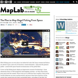
But large commercial fishers are about to get a new set of overseers: conservationists—and soon the general public—armed with space-based reconnaissance of the global fleet. Crews on big fishing boats deploy an impressive arsenal of technology—from advanced sonars to GPS navigation and mapping systems—as they chase down prey and trawl the seabed. These tools are so effective that roughly a third of the world’s fisheries are now overharvested, and more than three-quarters of the stocks that remain have hit their sustainable limits, according to the FAO. For some species, most of the catch is unreported, unregulated, or flat-out illegal.
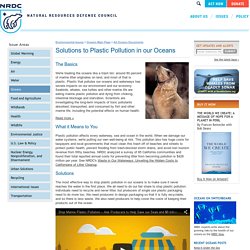
US Coast Guard cutter Rush escorting the illegal fishing boat Da Cheng back to China. US Coast Guard. Views Our Perpetual Ocean. 5 Gyres – Understanding Plastic Pollution Through Exploration, Education, and Action. Catalyst ABC TV - Plastic Oceans. Plastic Pollution in our Oceans. Environmental Issues > Oceans Main Page > All Oceans Documents The Basics We're treating the oceans like a trash bin: around 80 percent of marine litter originates on land, and most of that is plastic.
Plastic that pollutes our oceans and waterways has severe impacts on our environment and our economy. Seabirds, whales, sea turtles and other marine life are eating marine plastic pollution and dying from choking, intestinal blockage and starvation. Scientists are investigating the long-term impacts of toxic pollutants absorbed, transported, and consumed by fish and other marine life, including the potential effects on human health. Read more » What it Means to You Plastic pollution affects every waterway, sea and ocean in the world. Solutions The most effective way to stop plastic pollution in our oceans is to make sure it never reaches the water in the first place. NRDC is working on three key strategies to curb plastic water pollution in the U.S. and beyond: 1. 2. 3. What You Can Do 1. 2.
Pacific Ocean Warming at Fastest Rate in 10,000 Years. Just how rapid is the current rate of warming of the ocean?
There is an interesting new article by Rosenthal and collaborators in the latest issue of the journal Science entitled "Pacific Ocean Heat Content During the Past 10,000 Years" that attempts to address this question. The article compares current rates of ocean warming with long-term paleoclimatic evidence from ocean sediments. So how rapid is the ocean warming? Well, for the Pacific ocean at least, faster than any other time in at least the past 10,000 years. The study finds, specifically, that (to quote Columbia University's press release) the "middle depths [of the Pacific Ocean] have warmed 15 times faster in the last 60 years than they did during apparent natural warming cycles in the previous 10,000".
Beyond that key overall take-home conclusion, though, there are some enigmatic aspects of the study. There a few other minor, odd things about the study. Ocean Color Image Archive Page. NOTE: All SeaWiFS images presented here are for research and educational use only.
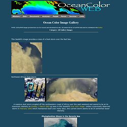
All commercial use of SeaWiFS data must be coordinated with GeoEye Category: All Gallery Images This SeaWiFs image provides a view of a Dust storm over the Red Sea. Northwest African Dust Storm A massive dust storm erupted off the northwestern coast of Africa over this past weekend and seemd to be at its maximum intensity on Sunday, 2 March 2003 as seen in this SeaWiFS true color image. OVERFISHING. SCIENCE FOCUS: DEAD ZONES — GES DISC: Goddard Earth Sciences, Data & Information Services Center. Info Home page for information about educational resources and outreach activities of the NASA Goddard Earth Sciences Data and Information Services Center The NASA Goddard Earth Sciences Data and Information Services Center (GES DISC) provides a broad variety of data to scientists around the world.
In addition to the data, the GES DISC has created several different tools that enable data users to categorize, view, order, visualize, and analyze the large volume of data it holds. Rabalais2002DeadZone.pdf (application/pdf Object) Hypoxia in oceans.pdf (application/pdf Object) Ocean dead zones image - Images: Google Earth 5.0 travels oceans, time, and space.
Dead zone (ecology) Red circles show the location and size of many dead zones.
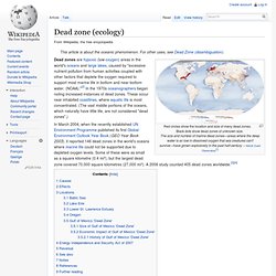
Black dots show dead zones of unknown size.The size and number of marine dead zones—areas where the deep water is so low in dissolved oxygen that sea creatures can't survive—have grown explosively in the past half-century. – NASA Earth Observatory[1] In March 2004, when the recently established UN Environment Programme published its first Global Environment Outlook Year Book (GEO Year Book 2003), it reported 146 dead zones in the world's oceans where marine life could not be supported due to depleted oxygen levels. Some of these were as small as a square kilometre (0.4 mi²), but the largest dead zone covered 70,000 square kilometres (27,000 mi²). A 2008 study counted 405 dead zones worldwide.[3][4] Climate has a significant impact on the growth and decline of ecological dead zones. Internationally celebrated limnologist Dr.
Marine Stewardship Council - home — MSC. Outreach and education at ESR. Sea Shepherd International.