
Library of Congress Geography and Maps: An Illustrated Guide. Color_etopo1_ice_low.jpg (JPEG Image, 5400×2700 pixels) - Scaled (24%) Map Collection Digital Maps. The Harvard Map Collection is one of the oldest and largest collections of cartographic materials in the United States with over 500,000 items.

Resources range from 16th century globes to modern maps and geographic information systems (GIS) layers. A selection of our materials has been digitally imaged and is offered both as true picture images and georeferenced copies. This Virtual Collection includes those maps and atlases that are available through the Harvard Image Delivery Service. Those maps that have been georeferenced are available through the Harvard Geospatial Library. Therefore, many of the maps listed will have two records, one for the image that is true to the original and the other a georeferenced image. Only a small portion of the Map Collection has been cataloged and included in the HOLLIS catalog and an even smaller selection are included in this virtual collection as digital images.
Map Collections Home Page. Gridded Population of the World - GPW v3. Introduction Note: "Gridded Population of the World, v4" is now available and supersedes GPWv3.

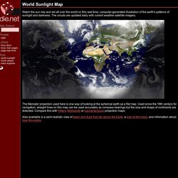
GPWv4 provides gridded population estimates with an output resolution of 30 arc-seconds (approximately 1 km at the equator) for the years 2000, 2005, 2010, 2015, and 2020 based on the results of the 2010 round of censuses, which occurred between 2005 and 2014. For more details about GPWv4 and to access the new data see GPWv3 depicts the distribution of human population across the globe. GPWv3 provides globally consistent and spatially explicit human population information and data for use in research, policy making, and communications. Population data estimates are provided for 1990, 1995, and 2000, and projected (in 2004, when GPWv3 was released) to 2005, 2010, and 2015. Earthquakes In The Last Week. Test Your Geography Knowledge- USA. World Sunlight Map. Watch the sun rise and set all over the world on this real-time, computer-generated illustration of the earth's patterns of sunlight and darkness.

The clouds are updated daily with current weather satellite imagery. The Mercator projection used here is one way of looking at the spherical earth as a flat map. Used since the 16th century for navigation, straight lines on this map can be used accurately as compass bearings but the size and shape of continents are distorted. Compare this with Peters, Mollweide or equirectangular projection maps. Also available is a semi-realistic view of dawn and dusk from far above the Earth, a look at the moon, and information about how this works. Mapping America — Census Bureau 2005-9 American Community Survey. Animated Manhattan. ACME Mapper 2.0. World-resources-map-r2.gif (GIF Image, 1450×1450 pixels) World Subways at Scale. Athens Attiko Metro.

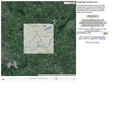
European Countries - Level Three. State and County QuickFacts. Google Maps Transparencies. Imagery ©2014 TerraMetrics Terms of Use Report a map error Map Satellite Map Data Map data ©2014 Google Google Maps Transparencies Click and drag anywhere, just like normal Google Maps, and see how the Map View matches the Satellite View (or vice-versa)

. - or - - or - Enter your own Latitude/Longitude in the format shown below. Built using the new Google Maps API Bugs, problems, suggestions? Link to this page. Atlas - Fresh Logic Studios.