
Curiosity. Mars 2020. Maven. Insight. NASA 3D-Printed Habitat Challenge. How NASA Plans to Land Humans on Mars. Posted By Jason Davis Topics: private spaceflight, SLS, Orion, future technology, human spaceflight, International Space Station On a warm, fall, southern afternoon, William Gerstenmaier stood in line at a lunch buffet on the campus of The University of Alabama in Huntsville.
The associate administrator for NASA's Human Exploration Directorate was smiling and shaking hands. You wouldn't know it to look at him, but just 16 hours earlier, Gerst—as he is referred to in the space community—phoned in to a nationally televised press conference to discuss the jaw-dropping explosion of an International Space Station-bound Antares rocket, launched by private spaceflight company Orbital Sciences Corporation. It's not surprising that Gerst didn't seem particularly shaken. On the surface, NASA's humans to Mars plans seem vague and disjointed. Boeing Mars lander concept Human exploration missions to Mars could require up to 20 tons of cargo on the surface. Focusing on the short term Like Phobos.
MSL Curiosity. Distances to Mt. Sharp. MSL Route Map - Unmanned Spaceflight.com. QUOTE (PaulH51 @ Jul 16 2013, 05:44 PM) Ed, do you have the 'kml' file with the Placemarks and path for MSL for GE Mars?

Or know where I can download one from? Well, I personally haven't created a GE route map with paths and markers yet. The files above are just image overlays of course. I did some searching last night for anybody on the web who's keeping one updated but didn't find anything yet. I did check out how far JPL's "Explore Mars" interactive app has come last night though. "We shall not cease from exploration, and the end of all our exploring will be to arrive where we started and know the place for the first time. " Navigating Mars' (#11442) Take an aerial tour of Curiosity's journey across the Red Planet.
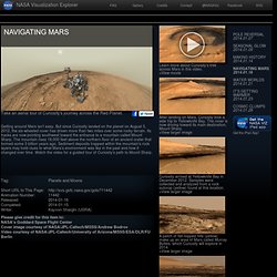
Getting around Mars isn’t easy. But since Curiosity landed on the planet on August 5, 2012, the six-wheeled rover has driven more than two miles over some rocky terrain. Its tracks are now pointing southwest toward the entrance to a mountain called Mount Sharp. The mountain rises 18,000 feet above the northern floor of an ancient crater that formed some 3 billion years ago. Sediment deposits trapped within the mountain’s rock layers may hold clues to what Mars’s environment was like in the past and how it changed over time. Short URL to This Page: Please give credit for this item to: NASA's Goddard Space Flight CenterCover image courtesy of NASA/JPL-Caltech/MSSS/Andrew BodrovVideo courtesy of NASA/JPL-Caltech/University of Arizona/MSSS/ESA/DLR/FU Berlin.
Curiosity's current path. Curiosity turns on self-driving software, can now navigate Mars on its own. Roughly 200 million miles away on the surface of the Red Planet, NASA’s Curiosity just one-upped Google: It autonomously drove across the surface of Mars without human supervision.
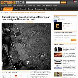
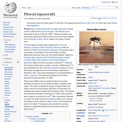
This is the first time that Curiosity has turned on its self-driving “autonav” software, and initial reports suggest that Curiosity navigated the treacherous surface of Mars flawlessly. The autonav software will help Curiosity reach its destination, Mount Sharp, much more quickly because the rover won’t have to wait for driving instructions from NASA — it can just plug away at the remaining kilometers autonomously. Up until yesterday, every movement made by Curiosity has been painstakingly keyed in by NASA, usually after performing simulations here on Earth using Curiosity’s stunt double (the Vehicle System Test Bed). Phoenix Mars Mission - Mission. The Phoenix Mars Mission has a collaborative approach to space exploration.
As the very first of NASA's Mars Scout class, Phoenix combines legacy and innovation in a framework of a true partnership: government, academia, and industry. Scout class missions are led by a scientist, known as a Principal Investigator (PI). Peter Smith of the University of Arizona's Lunar and Planetary Laboratory serves as Phoenix's PI and is responsible for all aspects of the mission. Phoenix (spacecraft) The multi-agency program was headed by the Lunar and Planetary Laboratory at the University of Arizona, under the direction of NASA's Jet Propulsion Laboratory.
The program was a partnership of universities in the United States, Canada, Switzerland, Denmark, Germany, the United Kingdom, NASA, the Canadian Space Agency, the Finnish Meteorological Institute, Lockheed Martin Space Systems, MacDonald Dettwiler & Associates (MDA) and other aerospace companies.[2] It was the first mission to Mars led by a public university in NASA history.[3] It was led directly from the University of Arizona's campus in Tucson, with project management at the Jet Propulsion Laboratory in Pasadena, Calif., and project development at Lockheed Martin in Denver, Colorado.
The operational funding for the mission extended through November 10, 2008. Phoenix was NASA's sixth successful landing out of seven attempts and was the first successful landing in a Martian polar region. The mission had two goals. Mass Power.