
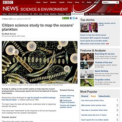
Citizen science study to map the oceans' plankton. 10 March 2014Last updated at 03:51 ET By Mark Kinver Environment reporter, BBC News The role phytoplankton plays in life on Earth is often overlooked, says Dr Richard Kirby A study is calling on the world's sailors to help map the oceans' phytoplankton, microscopic plants that form the bedrock of marine food chains.
Researchers have developed an app for people to submit readings from Secchi disks - a method used since 1865. Www.ig.uit.no/home/juergen/09GEO-3121.pdf. Svs.gsfc.nasa.gov/vis/a000000/a003600/a003658/thermohaline_conveyor_30fps.mp4. Timeline. Oceanography. BBC Earth - Oceans - What can rubber ducks tell us about them? What the Waves Brought: Japanese Tsunami Debris in North America. A 30-foot boat that washed ashore an Oregon beach on Feb. 5 has been linked back to the Japanese tsunami. The fiberglass hull, encrusted with barnacles and other marine life, was found at Gleneden Beach along Oregon’s Central Coast, due west of the state capital of Salem. Friendly Floatees. Route taken by the Friendly Floatees initially lost in the Pacific Ocean in 1992.
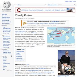
Friendly Floatees are plastic bath toys marketed by The First Years, Inc. and made famous by the work of Curtis Ebbesmeyer, an oceanographer who models ocean currents on the basis of flotsam movements including those of a consignment of Friendly Floatees, containing 29,000 plastic yellow ducks, red beavers, blue turtles and green frogs, washed into the Pacific Ocean in 1992. Some of the toys landed along Pacific Ocean shores, like Hawaii. Others traveled over 17,000 miles, floating over the site where the Titanic sank, and spent years frozen in Arctic ice to reach British and Irish shores 15 years later in 2007.[1] Oceanography[edit] A consignment of Friendly Floatee toys, manufactured in China for The First Years Inc., departed from Hong Kong on a container ship, the Ever Laurel,[2] destined for Tacoma, Washington, U.S..
Legacy[edit] See also[edit] [edit] References[edit] External links[edit] Bottle released by US scientist in 1956 to track ocean currents is found off Nova Scotia. BOSTON - It was April 1956, and the No. 1 song was Elvis Presley's "Heartbreak Hotel.
" Thousands of rubber ducks to land on British shores after 15 year journey. By BEN CLERKIN Last updated at 22:00 27 June 2007 They were toys destined only to bob up and down in nothing bigger than a child's bath - but so far they have floated halfway around the world.
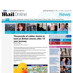
The armada of 29,000 plastic yellow ducks, blue turtles and green frogs broke free from a cargo ship 15 years ago. Since then they have travelled 17,000 miles, floating over the site where the Titanic sank, landing in Hawaii and even spending years frozen in an Arctic ice pack. And now they are heading straight for Britain. Statusbig.gif (2363×1092) Southern Ocean dredges up more surprises — SAMS. 22 Dec 2013, Oban -- Scientists have been surprised to discover that the strength of the world’s largest ocean current has remained similar over tens of thousands of years, despite vast differences in the world’s climate during that time.
The current circumnavigates the Antarctic and when analysed it showed that its strength in comparatively recent times matched its strength during the last ice age. This was unexpected because ocean circulation—a network of interconnected currents—is affected by climate, winds, the amount of heat entering the ocean, and the size of the sea ice field, some of which were considerably different between the times studied. This new information has given researchers a better insight in to how the current has responded to changes in its driving forces, and how it might change in the future. Known as the Antarctic Circumpolar Current (ACC), this current connects the Atlantic, Pacific and Indian Oceans.
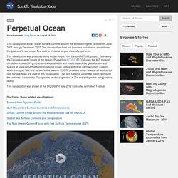
Links. SVS Animation 3827 - Perpetual Ocean. Short URL to share this page: Mission: Global Precipitation Measurement (GPM) Data Used: Hipparcos/Telescope/Tycho 2 Catalogue GTOPO30 Topography and Bathymetry ECCO2 High Resolution Ocean and Sea Ice Model 06/2006 - 12/2007.
Www.vub.ac.be/ANCH/educ/Marine Physico Chemistry Pdf version Chs 1 to 7/Chapter 2 Salt Temperature and Density.pdf. Temperature of Ocean Water. This is a simple temperature-depth ocean water profile.
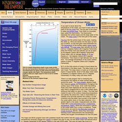
You can see temperature decreases with increasing depth. The thermocline are layers of water where the temperature changes rapidly with depth. This temperature-depth profile is what you might expect to find in low to middle latitudes. Click on image for full size Windows to the Universe original image. Ocean density. The density of seawater plays a vital role in causing ocean currents and circulating heat because of the fact that dense water sinks below less dense.
Salinity, temperature and depth all affect the density of seawater. Density is a measure of how tightly a certain amount of matter is packed into a given volume. The more the stuff is packed in, the higher the density. Density can be calculated by dividing an object’s mass by its volume. It is commonly measured in grams per millilitre or grams per cubic centimetre. BBC Nature - 'Brinicle' ice finger of death. Natural History Nature Documentary. Understanding large-scale global climate and local weather patterns is important.
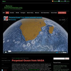
Majority of our planet is covered by oceans therefore understanding ocean dynamics is key for making climatic forecasts. Here you can watch four interrelated animations produced by NASA’s Scientific Visualization Studio in a single video. All animations are based on simulations of high resolution satellite data on an impressively realistic General Circulation Model (GCMs) that NASA uses called ECCO2 (Estimating the Circulation and Climate of the Ocean Phase II). These simulations based on real data is crucial for understanding major global problems such as ocean acidification due to increased carbondioxide levels in the atmosphere.
First animation called “Perpetual Ocean” shows ocean surface currents measured between July 2005 and December 2007. World Ocean Gyres. Garbage Island: An Ocean Full of Plastic (Part 1/3) Hypnotic interactive globe reveals our planet's powerful sea currents in REALTIME. Created by Tokyo-based Cameron Beccario, users can drag the globe to their desired location and click to zoom inA region that looks calm at a first glance is seen as an active area of currents circling as the user moves closer inIt follows an interactive global wind map, also created by Mr Beccario.
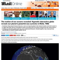
Studied together, they reveal just how unpredictable our planet’s weather system can be By Ellie Zolfagharifard and Sam Webb Published: 15:25 GMT, 6 February 2014 | Updated: 15:26 GMT, 6 February 2014. Ocean Currents and Climate. Ocean Currents and Climate There are two type of Ocean Currents: Oceanography. Driven by forces such as wind, tides, and gravity, currents keep our oceans in constant motion. Currents move large amounts of water great distances. Countless currents have been named, but the seven major ones are the West Wind Drift (or the Antarctic Circumpolar Current), East Wind Drift, the North and South Equatorial currents, the Peru Current, the Kuroshio Current and the Gulf Stream.
These currents flow in large rotating loops called gyres. In the Northern Hemisphere, gyres spin in a clockwise direction, and in the Southern Hemisphere, gyres spin in a counterclockwise direction.