
Earth's water shown condensed into a sphere over the US. About 71 percent of the Earth is water, but when concentrated into one area it forms an 860 miles wide sphere.
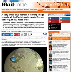
The findings come from a recently updated map created by the US Geological Survey to show what it looks like if all the water one the planet is condensed into a sphere over the US. The sphere for fresh liquid water would be 169.5 miles in diameter and fresh-water lakes and rivers make a tiny 34.9 miles bubble. About 71 percent of the Earth is water, but when concentrated into one area it forms an 860 miles wide sphere. The sphere for fresh liquid water would be 169.5 miles in diameter and fresh-water lakes and rivers make a tiny 34.9 miles dot.
The reason why you can smell the seaside is traced to algal enzyme. Seaside smell is produced by wind-borne compound called dimethylsulfideAn enzyme in the algae Emiliania huxleyi is what produces the compoundIt serves as a powerful signal to birds and animals so they can find the seaCompound is also thought to be involved in cloud formation and weather By Richard Gray for MailOnline Published: 17:00 GMT, 26 June 2015 | Updated: 18:15 GMT, 26 June 2015.

Oceanography. Oceanography (compound of the Greek words ὠκεανός meaning "ocean" and γράφω meaning "write"), also known as oceanology and marine science, is the branch of Earth science that studies the ocean. It covers a wide range of topics, including marine organisms and ecosystem dynamics; ocean currents, waves, and geophysical fluid dynamics; plate tectonics and the geology of the sea floor; and fluxes of various chemical substances and physical properties within the ocean and across its boundaries.
These diverse topics reflect multiple disciplines that oceanographers blend to further knowledge of the world ocean and understanding of processes within: astronomy, biology, chemistry, climatology, geography, geology, hydrology, meteorology and physics. History[edit] Early history[edit] Our planet is invested with two great oceans; one visible, the other invisible; one underfoot, the other overhead; one entirely envelopes it, the other covers about two thirds of its surface. Modern oceanography[edit] Ocean. An ocean (from Ancient Greek Ὠκεανός, transc.
Okeanós, the sea of classical antiquity[1]) is a body of saline water that composes much of a planet's hydrosphere.[2] On Earth, an ocean is one of the major conventional divisions of the World Ocean, which occupies two-thirds of the planet's surface. These are, in descending order by area, the Pacific, Atlantic, Indian, Southern, and Arctic Oceans.[3][4] The word sea is often used interchangeably with "ocean" in American English but, strictly speaking, a sea is a body of saline water (generally a division of the world ocean) partly or fully enclosed by land.[5] Earth's global ocean[edit] Global divisions[edit]
Pacific Ocean. The Pacific Ocean At 165.25 million square kilometres (63.8 million square miles) in area, this largest division of the World Ocean – and, in turn, the hydrosphere – covers about 46% of the Earth's water surface and about one-third of its total surface area, making it larger than all of the Earth's land area combined.[1] The equator subdivides it into the North Pacific Ocean and South Pacific Ocean, with two exceptions: the Galápagos and Gilbert Islands, while straddling the equator, are deemed wholly within the South Pacific.[2] The Mariana Trench in the western North Pacific is the deepest point in the world, reaching a depth of 10,911 metres (35,797 ft).[3] The eastern Pacific Ocean was first sighted by Europeans in the early 16th century when Spanish explorer Vasco Núñez de Balboa crossed the Isthmus of Panama in 1513 and discovered the great "southern sea" which he named Mar del Sur.
History Important human migrations occurred in the Pacific in prehistoric times. Atlantic Ocean. The Atlantic Ocean occupies an elongated, S-shaped basin extending longitudinally between Eurasia and Africa to the east, and the Americas to the west.
Indian Ocean. The Indian Ocean, not including the Antarctic region.
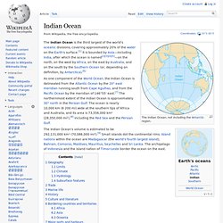
The Indian Ocean is the third largest of the world's oceanic divisions, covering approximately 20% of the water on the Earth's surface.[1] It is bounded by Asia—including India, after which the ocean is named[2][3][4][5]—on the north, on the west by Africa, on the east by Australia, and on the south by the Southern Ocean (or, depending on definition, by Antarctica).[6] As one component of the World Ocean, the Indian Ocean is delineated from the Atlantic Ocean by the 20° east meridian running south from Cape Agulhas, and from the Pacific Ocean by the meridian of 146°55' east.[7] The northernmost extent of the Indian Ocean is approximately 30° north in the Persian Gulf.
The ocean is nearly 10,000 km (6200 mi) wide at the southern tips of Africa and Australia, and its area is 73,556,000 km² (28,350,000 mi²),[8] including the Red Sea and the Persian Gulf. Geography[edit] Limits[edit] Climate[edit] Hydrology[edit] Subsurface features[edit] Southern Ocean. Arctic Ocean. "Arctic Sea" redirects here.
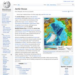
For the cargo ship, see MV Arctic Sea. Almost completely surrounded by Eurasia and North America, the Arctic Ocean is partly covered by sea ice throughout the year[4] (and almost completely in winter). The Arctic Ocean's surface temperature and salinity vary seasonally as the ice cover melts and freezes;[5] its salinity is the lowest on average of the five major oceans, due to low evaporation, heavy fresh water inflow from rivers and streams, and limited connection and outflow to surrounding oceanic waters with higher salinities.
The summer shrinking of the ice has been quoted at 50%.[1] The US National Snow and Ice Data Center (NSIDC) uses satellite data to provide a daily record of Arctic sea ice cover and the rate of melting compared to an average period and specific past years. History[edit] For much of European history, the north polar regions remained largely unexplored and their geography conjectural. Ocean gyre. The five major ocean gyres A gyre in oceanography is any large system of rotating ocean currents, particularly those involved with large wind movements.
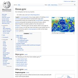
Gyres are caused by the Coriolis Effect; planetary vorticity along with horizontal and vertical friction, which determine the circulation patterns from the wind curl (torque).[1] The term gyre can be used to refer to any type of vortex in the air or the sea, even one that is man-made, but it is most commonly used in oceanography to refer to the major ocean systems. Major gyres[edit] The following are the five most notable gyres:[2] Other gyres[edit]
Seafloor spreading. Age of oceanic crust; youngest (red) is along spreading centers.
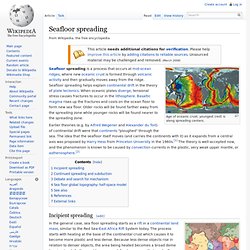
Seafloor spreading is a process that occurs at mid-ocean ridges, where new oceanic crust is formed through volcanic activity and then gradually moves away from the ridge. Seafloor spreading helps explain continental drift in the theory of plate tectonics. When oceanic plates diverge, tensional stress causes fractures to occur in the lithosphere. Basaltic magma rises up the fractures and cools on the ocean floor to form new sea floor. Older rocks will be found farther away from the spreading zone while younger rocks will be found nearer to the spreading zone. Mid-Atlantic Ridge. The location of the Mid-Atlantic Ridge The ridge was central in the breakup of the hypothetical Pangaea that began some 180 million years ago.
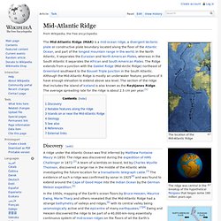
The Mid-Atlantic Ridge (MAR) is a mid-ocean ridge, a divergent tectonic plate or constructive plate boundary located along the floor of the Atlantic Ocean, and part of the longest mountain range in the world. In the North Atlantic, it separates the Eurasian and North American Plates, whereas in the South Atlantic it separates the African and South American Plates. The Ridge extends from a junction with the Gakkel Ridge (Mid-Arctic Ridge) northeast of Greenland southward to the Bouvet Triple Junction in the South Atlantic.
Although the Mid-Atlantic Ridge is mostly an underwater feature, portions of it have enough elevation to extend above sea level. Discovery[edit] A ridge under the Atlantic Ocean was first inferred by Matthew Fontaine Maury in 1850. Mid-ocean ridge. A mid-ocean ridge is a general term for an underwater mountain system that consists of various mountain ranges (chains), typically having a valley known as a rift running along its spine, formed by plate tectonics. This type of oceanic ridge is characteristic of what is known as an oceanic spreading center, which is responsible for seafloor spreading. The uplifted seafloor results from convection currents which rise in the mantle as magma at a linear weakness in the oceanic crust, and emerge as lava, creating new crust upon cooling.
A mid-ocean ridge demarcates the boundary between two tectonic plates, and consequently is termed a divergent plate boundary. Mariana Trench. Coordinates: Location of the Mariana Trench The Mariana Trench or Marianas Trench[1] is the deepest part of the world's oceans. It is located in the western Pacific Ocean, to the east of the Mariana Islands. The trench is about 2,550 kilometres (1,580 mi) long but has an average width of only 69 kilometres (43 mi). It reaches a maximum-known depth of 10.911 km (10,911 ± 40 m) or 6.831 mi (36,069 ± 131 ft) at the Challenger Deep, a small slot-shaped valley in its floor, at its southern end,[2] although some unrepeated measurements place the deepest portion at 11.03 kilometres (6.85 mi).[3]
Ocean trench: Take a dive 11,000m down. Icy cold, pitch black and with crushing pressures - the deepest part of the ocean is one of the most hostile places on the planet. Only three explorers have made the epic journey there: 11km (seven miles) down to the bottom of the Pacific Ocean's Mariana Trench. As a new wave of deep-sea exploration begins, take a look at the mysterious world that they will be plunging into. Pressure Test: Diving 100m down With the help of some polystyrene heads, science reporter Rebecca Morelle finds out what happens at the pressure experienced 100m below sea level. Pressure Test: Diving 1,000m down The BBC's Rebecca Morelle reveals what happens to a polystyrene head as it is subjected to the pressure 1,000m below the waves. Race to the bottom of the ocean: Why go down? Hydrothermal vent. Physical properties[edit] Magnified Image Reveals the Unbelievable Things Lurking in a Splash of Seawater. For anyone who's ever accidentally swallowed a gulp of salty seawater, watch out—this photo might make you a little queasy.
Photographer David Liittschwager captured this eye-opening image that reveals the unbelievable contents in a random splash of seawater, magnified 25 times. As we can see, even the smallest drop of seawater is home to an incredible variety of tiny creatures and plants that are collectively known as plankton. Where did Earth’s Water Come From? Image Credit: Don Davis Where did Earth’s water come from? That is a question that has puzzled scientists for many years. The prevailing theory has been that our water came from comets that formed in the outer solar system and then crashed into Earth in our early history. A new study, on the other hand, shows that theory just doesn’t hold water. This study, brought to us from the Carnegie Institution, shows that water ice was instead transported to Earth by asteroids that formed in the inner solar system.
The Provenances of Asteroids, and Their Contributions to the Volatile Inventories of the Terrestrial Planets. How Much Water is on Earth? The US Geological Survey (USGS) recently published a remarkable image helping us appreciate the preciousness of water. We have all probably heard the oft-quoted statistic that about how 70 percent of the Earth’s surface is water-covered – most of it in the form of oceans. Though it sounds like a lot, if we gathered all that water up, how much space would it take up? This Tiny Sphere is All the World’s Water.
Fascinating animation shows the ever-changing temperatures of our oceans. By Daily Mail Reporter Published: 21:54 GMT, 23 June 2012 | Updated: 11:39 GMT, 24 June 2012. 'Supergiant' crustacean found in deepest ocean. 2 February 2012Last updated at 08:54 By Rebecca Morelle Science reporter, BBC News Dr Ashley Rowden, scientist: "It's great to be on a ship when something unusual comes up on deck" A huge crustacean has been found lurking 7km down in the waters off the coast of New Zealand. The creature - called a supergiant - is a type of amphipod, which are normally around 2-3cm long. Meet the creatures that live beyond the abyss. Our fascination with the deepest of the deep was sparked by an extraordinarily dangerous expedition that took place 50 years ago. Deep-sea fish captured on camera. These fish were photographed at a depth of 7,560m.