
Ajouter et personnaliser des symboles SVG depuis QGIS. La bilbiothèque de symboles SVG de QGIS est assez complète mais comment ajouter d'autres symboles et surtout comment pouvoir changer la couleur et l'épaisseur des contours directement depuis QGIS ?
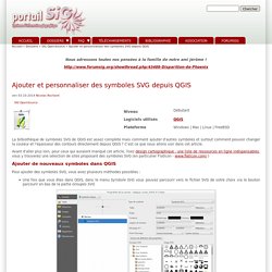
C'est ce que nous allons voir dans cet article. Avant d'aller plus loin, pour ceux qui auraient manqué cet article, lisez design cartographique : une liste de ressources en ligne indispensables, vous y trouverez une sélection de sites proposant des symboles SVG (en particulier FlatIcon - www.flaticon.com/ ) SVG symbols in QGIS with modifiable colors - Sourcepole. SVG markers are a popular way to symbolise points in QGIS.
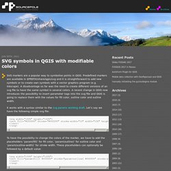
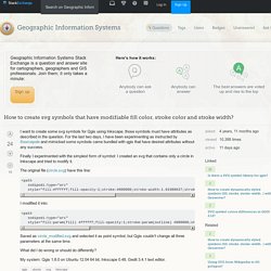
Predefined markers are available in $PREFIX/share/qgis/svg and it is straightforward to add new symbols or to create own symbols with a vector graphics program (e.g. Inkscape). A disadvantage so far was the need to create different versions of an svg file to have the same symbol in several colors. A recent change in QGIS now introduces the possibility to insert parameter tags into the svg file and QGIS is going to replace them with the values for fill color, outline color and outline width. Qgis - How to create svg symbols that have modifiable fill color, stroke color and stroke width? It seems worth providing a simple answer about the basics of SVGs to go alongside the details provided here about specifics around software...
QGIS 2016. Ajouter et personnaliser des symboles SVG depuis QGIS. How to make Geological Map and Cross sections using Quantum GIS – steelandrocks.com. I hope you liked the previous post/tutorial on Cartography and GIS: How to make vintage map This is another post related to Quantum GIS usage.
This time I will show you how you can simply work with geological map using Quantum GIS and also how to make geological cross sections using this map and QGIS dedicated plugins. You will need: Quantum GIS – download free version on Elevation Model of your area or digitzed topo mapYour field measurements (stratigraphy, strike, dips measurements, identified faults, etc.)Graphics editor such as Corel Draw or Inkscape First what you would like to display are your field measurements. Also you can digitize the strike/dip values from existing archival maps. The same you can do with the faults – interpret them by yourself using aerial photos, geology etc. or just digitize them from existing maps if you believe them. QGIS Geology Symbology - Browse /svg/geology at SourceForge.net. By INSIGHT. SubsurfaceViewer® is designed to visualize subsurface matters in a most comprehensive way: It allows geologists to produce, on the fly, a potentially unlimited number of views on geological data and digital subsurface models.
This is possible, because all different kinds of subsurface data can be combined and represented in any number of combinations. The object-based philosophy of the SubsurfaceViewer distinguishes it from other applications that just enable the user to produce single images or maps for printouts. SubsurfaceViewer provides the geologist with access to all geological objects of the subsurface (like drilling profiles, cross-sections, DTMs, geologic layers, etc.), so you can, at any time, select, combine and display all objects under various aspects; from different angles, at any level of enlargement, etc.
You can, of course, look at and analyse each individual object in the way you desire. NGMDB - Digital Mapping Techniques. The Digital Mapping Techniques workshops are an outcome of collaboration between the state geological surveys (represented by the Association of American State Geologists, or AASG), and the U.S.
Geological Survey. In August,1996, the AASG and USGS met in in St. Louis, Missiouri, to plan for development of standards and guidelines under the newly-established National Geologic Map Database. At that meeting, a Data-Capture Working Group was formed, and charged with "Providing guidance on data-capture techniques through facilitation of information exchange" and "conducting workshops to share experiences and insight and evaluate technology. " This Working Group organized the first Digital Mapping Techniques workshop, in 1997, and was active for several years thereafter. Each workshop consists of oral and poster presentations, and numerous informal discussion sessions; many are supported by a paper contained in the Proceedings volumes listed below. Visualiser en 3D un Modèle Numérique de Terrain avec Qgis2threejs — Makina Corpus. Construction of geological cross sections in QGIS. The Earth’s surface forms the interface between our human view of the world and the geology preserved beneath our feet.
Variations in this surface are depicted on maps as contoured elevation data or graduated raster images (with colour scales referenced to elevation magnitude). These elevation models can be combined with geological maps to create a 3-dimensional view (or model) of the subsurface. Establishing this view is often a critical step towards understanding the geometries and relationships of subsurface features such as stratigraphy, faults, intrusions, caves and mineral deposits. It is also hugely beneficial when attempting to relate these features to more philosophical aspects such as Earth structure and geological evolution. The process of building 3-dimensional models has become increasingly automated through the development of specialized software, complex algorithms and a whole lot of arm-waving. 4. 5.
Now the fun begins… To add Points (e.g. Index of /pub/pavlis/tuitorials. Downloads. This is a link to resources we have developed here at UTEP.
There are two things here: Downloads: The downloads link simply takes you to some generic files for digital mapping using GIS systems. They are all shapefiles. The shapefiles contain .api files for arcpad (layer definitions that automate data entry and linework). We have completely abandoned Arcpad though, so instead I would highly recommend you use the QGIS projects. Digital Field Geology and Digital Geologic mapping. Overview: This website is dedicated to interchange of information on digital geologic mapping.
Topics include information on hardware, software, techniques, and discussions of anything people want to discuss in the use of this evolving technology. I will also try to keep a blog of sorts (although I hate the things) when I learn of new things, etc. In my opinion this technology fundamentally changes the way we do field studies in the geosciences, and probably all field sciences. Nonetheless, we have a long way to go in perfecting these systems. Thus, it is my hope that the information contained here as well as tthe forums will help promote the use of the technology across the geosciences. QGIStutorial_qgis2only. Midland Valley : The Structural Geology Experts. PyQGIS (QGIS 2): les coupes géologiques (colorisation d'un profil topographique élaboré à partir d'un MNT en fonction des couleurs d'un raster et placement des points d'intersection avec les limites des couches géologiques) Pour les géologues, créer une coupe géologique à partir d'un logiciel SIG classique est un problème récurrent, surtout lorsque il ne dispose pas d'une application qui gère la 3D (comme GRASS GIS ou ArcGIS avec des extensions très chères).
Il s'agit de: Geological Musings in the Taconic Mountains...: Creating Geologic Maps in QGIS: Strike and Dip Symbols. Last week I had a brief Twitter conversation with @polarwander about the feasibility of using QGIS for geologic mapping.
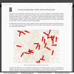
If you've read any of my posts (rants?) Before, it will come as no surprise that my usual response to any question that starts out "Can I use QGIS for... " is yes. There are limitations and things that are easier in other software packages but the integration of GRASS, Saga, TauDEM, etc., within the Processing Toolbox makes it a viable option for most situations. QGIS et géologie structurale: création automatique de rosaces directionnelles et de canevas stéréographiques avec PyQGIS. Découverte de QGIS via la cartographie géologique.