References. Index.html. Map projection. More generally, the surfaces of planetary bodies can be mapped even if they are too irregular to be modeled well with a sphere or ellipsoid; see below.
Even more generally, projections are the subject of several pure mathematical fields, including differential geometry and projective geometry. However "map projection" refers specifically to a cartographic projection. Background[edit] Maps can be more useful than globes in many situations: they are more compact and easier to store; they readily accommodate an enormous range of scales; they are viewed easily on computer displays; they can facilitate measuring properties of the terrain being mapped; they can show larger portions of the Earth's surface at once; and they are cheaper to produce and transport. These useful traits of maps motivate the development of map projections. However, Carl Friedrich Gauss's Theorema Egregium proved that a sphere's surface cannot be represented on a plane without distortion. How to choose a projection. Choosing a projection Even with all you've learned about map projections, you may feel that you still don't know how to pick a good one—that is, a projection that meets your needs.
So what makes a projection good? Two main things. Arthur H. Robinson, el geógrafo que reinterpretó el mapamundi. Arthur H.
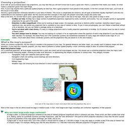
Robinson, geógrafo que mejoró la proyección de Mercator para dibujar la Tierra redonda en un mapa plano, falleció el 10 de octubre en Madison, Winconsin, a los 89 años. Su muerte, tras una breve enfermedad, fue anunciada por la Universidad de Wisconsin, donde era profesor emérito de Geografía y Cartografía. Proyección de Robinson. Una proyección de Robinson de la Tierra.
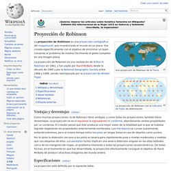
La proyección de Robinson es una proyección cartográfica del mapamundi, que muestra todo el mundo en un plano. Fue creada específicamente con el objetivo de encontrar un buen consenso al problema de mostrar fácilmente el globo completo en una imagen plana. La proyección de Robinson es una realización de Arthur H. Mapas con diferentes proyecciones. ¿Qué es un mapa de proyección Robinson? Los fabricantes de mapas se refieren a éstos como proyecciones, que representan una superficie tridimensional como una plana de dos dimensiones.
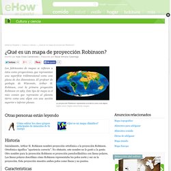
El profesor de geología de Wisconsin, Arthur H. Robinson, creó la primera proyección Robinson en 1963. Este tipo de mapa es el más común que representa al planeta tierra como una elipse con una sección superior e inferior planas. Historia Inicialmente, Arthur H. Características. El eurocentrismo comienza en los mapas. Mercator Projection v. Gall-Peters Projection. Because the Earth is roughly spherical, every flat map distorts our planet one way or another.

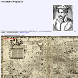
The most popular version is the Mercator projection, created by Flemish cartographer Gerardus Mercator in 1569. It's been widely used for centuries, including today in various forms by Google Maps and many other online services. This map preserves directional bearing, presenting rhumbs (imaginary lines that cut all meridians at the same angle) as straight lines, thus making it a useful tool for navigation. Despite its benefits, the Mercator projection drastically distorts the size and shape of objects approaching the poles.
This may be the reason people have no idea how big some places really are. Wikimedia CommonsThe Mercator projection. A few major misconceptions based on this map: Alaska is nearly as large as the continental U.S.Greenland is roughly the same size as Africa.Europe (excluding Russia) is only a bit larger than South America.Antarctica dwarfs all the continents. Mercator's Projection. The Mercator projection was invented by Gerardus Mercator, a Flemish mapmaker.
Distortions from Different Map Projections. Each of the different types of projections have strenghts and weaknesses.
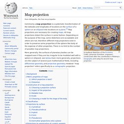
Knowledge of these different advantages and disadvantages for a particular map projection will often help in which map to choose for a particular project. The basic problem inherent in any type of map projection is that it will result in some distortion of the ‘ground truth’ of the area being mapped. There are four basic characteristics of a map that are distorted to some degree, depending on the projection used.
These characteristics include distance, direction, shape, and area. The only place on a map where there is no distortion is along the trace of the line that marks the intersection of our ‘paper’ with the surface of the earth. What is distortion on a map and why does it occur. Robinson projection. Why every world map you're looking at is WRONG: Africa, China and India are distorted despite access to accurate satellite data. The distortion is the result of the Mercator map which was created in 1596 to help sailors navigate the worldIt gives the right shapes of countries but at the cost of distorting sizes in favour of the wealthy lands to the northFor instance, north America looks larger, or at least as big, as Africa, and Greenland also looks of comparable sizeIn reality, you can fit north America into Africa and still have space for India, Argentina, Tunisia and some left overMap suggests Scandinavian countries are larger than India, whereas in reality India is three times the size The biggest challenge for cartographers is that it is impossible to portray reality of spherical world on a flat map By Ellie Zolfagharifard Published: 10:40 GMT, 4 April 2014 | Updated: 12:38 GMT, 7 May 2014.