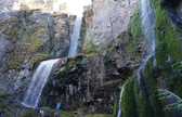
NWCC Report Generator. NWCC Report Generator. NWCC Report Generator. The Newton Clark Moraine. Mount Hood and the Newton Clark Moraine from Bennett Pass Road Tucked on the remote east shoulder of Mount Hood is the Newton Clark Moraine, the largest glacial formation on the mountain, and one of its most prominent features.
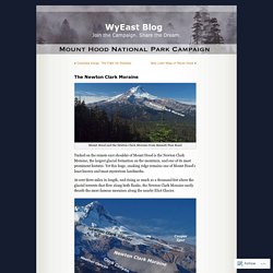
Yet this huge, snaking ridge remains one of Mount Hood’s least known and most mysterious landmarks. At over three miles in length, and rising as much as a thousand feet above the glacial torrents that flow along both flanks, the Newton Clark Moraine easily dwarfs the more famous moraines along the nearby Eliot Glacier. East Face Detail with Newton Clark Moraine How big is it? Backcountry skiers often call the moraine “Pea Gravel Ridge”, which is a poor choice of words, as pea gravel is something you would expect in tumbled river rock.
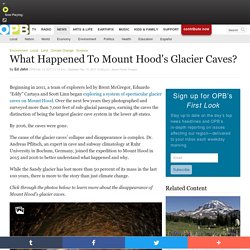
OPB · Thin Ice: Exploring Mount Hood's Glacier Caves. In the 1950s, mountaineering legend Lou Whittaker took thousands of people to see the ice caves.
He was fresh out of college at the time. A guided summit climb cost $28. The ice caves were just $5. Few people climbed Rainier back then. “We’d rappel off the balcony on the lodge and land on the floor and say, let us tell you about the ice cave trips, and see if we could talk them into the five dollar fee,” Whittaker says. MAPS — MITCHELL GEOGRAPHY. Clickable Map of Oregon SNOTEL Sites. NWCC Report Generator. How to select a station?
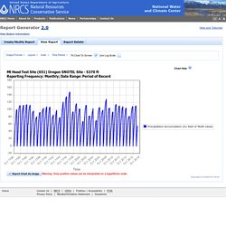
The input field for selecting a station is an auto-suggest input field. You can select stations by first selecting a network in the "Select network" pull-down and then typing some or all of a station id or station name in the "Enter station(s)" box. Once a search string is entered, a list of the first 10 matches will be provided. If the first character entered is a digit, it will look for station ids that match, otherwise it will look for station names that match. Click on a station to add it to the list of selected stations. The wildcard characters '*' (match any zero or more characters) and '?
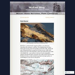
' As you type more characters, the list of suggestions will change to match the current search pattern. NRCS National Water and Climate Center. National Centers for Environmental Information. National Centers for Environmental Information. National Centers for Environmental Information. National Centers for Environmental Information. Reid Glacier. Soft evening light on Reid Glacier and Illumination Rock.
New Glaciers on Mount Hood? It seems implausible, but climate change may be creating new glaciers on Mount Hood — but not in the usual way that glaciers are created.
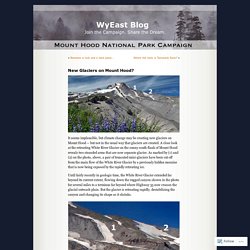
A close look at the retreating White River Glacier on the sunny south flank of Mount Hood reveals two stranded arms that are now separate glacier. As marked by (1) and (2) on the photo, above, a pair of truncated mini-glaciers have been cut off from the main flow of the White River Glacier by a previously hidden moraine that is now being exposed by the rapidly retreating ice. Sandy Glacier Caves: Realm of the Snow Dragon. The Sandy Glacier is front and center in the classic view of Mount Hood from Lolo Pass Oregon Public Broadcasting’s venerable Oregon Field Guide series kicks off it’s 25th season in October with a remarkable story on the hidden network of glacier caves that have formed under the Sandy Glacier, high on Mount Hood’s west flank.
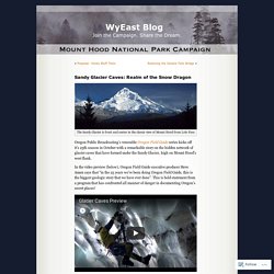
In the video preview (below), Oregon Field Guide executive producer Steve Amen says that “in the 25 years we’ve been doing Oregon Field Guide, this is the biggest geologic story that we have ever done”. This is bold statement from a program that has confronted all manner of danger in documenting Oregon’s secret places! Glacier caves are formed by melt water seeping through glaciers and flowing along the bedrock beneath glaciers. Over time, intricate networks of braided tunnels can form. Glaciers of the American West. Babson, S.
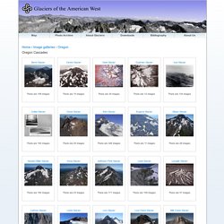
G., 1997, Letters from Arnold Hague: early Mount Hood explorer, Volume 98, Oregon Historical Quarterly, p. 206-221. Coleman, E. T., 1878, Mountains and mountaineering in the Far West: The Alpine Journal, v. 8, no. 59, p. 385-398 Dethier, D. P., 1980, Reconnaissance study of Holocene glacier fluctuations in the Three Sisters area, Oregon: Eos Transactions American Geophysical Union, v. 61, no. 6, p. 69. Glaciers of the American West. Home › Image galleries › Oregon Oregon Cascades Portland State University © 2009, All Rights Reserved This page maintained by: Academic & Research Computing.
What Happened To Mount Hood's Glacier Caves? . News. Beginning in 2011, a team of explorers led by Brent McGregor, Eduardo “Eddy” Cartaya and Scott Linn began exploring a system of spectacular glacier caves on Mount Hood.
GLACIER REPHOTO DATABASE: MOUNT HOOD. In 2012, supported by funding from a Mazamas research grant, PSU geologist Hassan Basagic visited numerous mountains in the Pacific Northwest in order to duplicate glacier photographs originally recorded early in the 20th century.
He is now compiling those images for his Glacier Repeat Photography Database, a website which "seeks to summarize the existing glacier repeat photographic record throughout the American West. " Mr.