
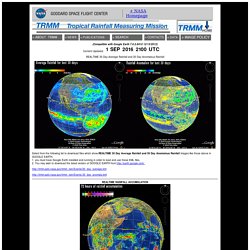
SEA LEVEL STATION MONITORING FACILITY. Hurricanes & Tropical Cyclones. Weather Forecast Nakhon Si Thammarat. Windyty, wind map & forecast. The Philippines' First Website on Tropical Cyclones (Since 1997) PAGASA-DOST. MeteoEarth.com - Interactive 3D globe brings weather to life. TRMM. Experimental 24 HOUR FORECAST USING MERGED SATELLITE RAINFALL (3B42) AUGMENTED BY NASA GEOS-5 FORECAST MODEL Experimental EXTENDED FORECAST (UP TO 5 DAYS) USING MERGED SATELLITE RAINFALL (3B42) AUGMENTED BY NASA GEOS-5 FORECAST MODEL DATA Click here to download GOOGLE_SOUTH_AFRICA_FLOOD_POTENTIAL.kml ____________________ GOOGLE_SOUTH_AFRICA_rain_accumulation_3hr.kml ____________________ GOOGLE_SOUTH_AFRICA_rain_accumulation_24hr.kml ____________________ GOOGLE_SOUTH_AFRICA_rain_accumulation_72hr.kml LET ME KNOW ABOUT PROBLEMS OR GIVE SUGGESTIONS --> Harold.F.Pierce@nasa.gov.
Rapid Response - LANCE - Subsets. Map.longdo. Kart. Weather Satellite Imagery. Fullscreen — กรุงเทพฯ: Skyline from Sathorn Road. RAMSDIS Online - Himawari-8 Imagery. Skip navigation Cooperative Research Program (CoRP) | Center for Satellite Applications and Research (STAR) Himawari-8 Imagery Imagery courtesy of the Japanese Meteorological Agency Please visit our new Himawari-8 Loop of the Day page.
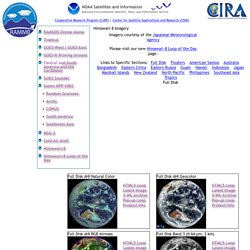
Links to Specific Sections: Full Disk Full Disk AHI Natural Color Full Disk AHI Geocolor Full Disk AHI RGB Airmass Full Disk Band 3 (0.64 µm, 2 km) Floaters 10 Minute Floater 1 Band 3 (0.64 µm, 0.5 km) Rapid Scan Floater 2 Band 3 (0.64 µm, 0.5 km) 10 Minute Floater 3 Band 3 (0.64 µm, 0.5 km) American Samoa American Samoa AHI Natural Color American Samoa AHI Geocolor American Samoa AHI RGB Airmass. NATIONAL METEOROLOGICAL CENTER OF CMA. Current Storm Information - Tropical Tidbits. Global Tropical Cyclone and Disturbance Information This page is automatically updated every 15 minutes with the latest information on active storms and disturbances in all ocean basins from the Automated Tropical Cyclone Forecast system (ATCF).
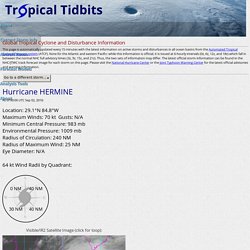
Note for the Atlantic and eastern Pacific: while this information is official, it is issued at 6-hourly intervals (0z, 6z, 12z, and 18z) which fall in between the normal NHC full advisory times (3z, 9z, 15z, and 21z). Thus, the two sets of information may differ. The latest official storm information can be found in the NHC/JTWC track forecast image for each storm on this page. Please visit the National Hurricane Center or the Joint Typhoon Warning Center for the latest official advisories and warning information.
Hurricane HERMINEAs of 00:00 UTC Sep 02, 2016: 64 kt Wind Radii by Quadrant: Note that the most recent hour may not be fully populated with stations yet. Hurricane GASTONAs of 00:00 UTC Sep 02, 2016: TYPHOON AND WEATHER IMAGERY. RealEarth™ - Google Maps. Digital Typhoon: Typhoon 201601 (NEPARTAK) - General Information (Pressure and Track Charts) Navy/NRL TC_PAGES Page. StormTracker. StormTracker provides a mapped picture of tropical cyclones (tropical storms, hurricanes, typhoons) around the globe.
Note, it does not include mid-latitude storms named as part of the Met Office and Met Eireann 'Name Our Storms' Project. StormTracker provides access to the following: Track history of all current tropical cyclones Six-day forecast tracks for current tropical cyclones from the Met Office Unified Model Latest observed cloud cover (infra-red and visible satellite) and sea surface temperature StormTracker provides general guidance on current tropical cyclone activity and one possible forecast outcome. It should not be used on its own to formulate a definitive decision based on this one outcome occurring.
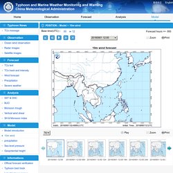
Warnings and guidance Active tropical cyclones can be selected from the drop down list above the map. What are the storm names used in StormTracker? StormTracker displays the observed and forecast tracks of all currently active tropical cyclones. Weather photo taken by realtime webcams. NATIONAL METEOROLOGICAL CENTER OF CMA. Zoom Print Play.
สรุปสถานการณ์น้ำ. ThaiWater:IGIS. ศูนย์ปฏิบัติการเฝ้าระวังและเตือนภัย น้ำหลาก - ดินถล่ม สำนักวิจัย พัฒนาและอุทกวิทยา กรมทรัพยากรน้ำ. Earthquake-Report.com. PAGASA-DOST. Live Earthquakes Map. รายงานแผ่นดินไหว (@THQuake) RAMSDIS Online - Himawari-8 Imagery. Skip navigation Cooperative Research Program (CoRP) | Center for Satellite Applications and Research (STAR) Himawari-8 Imagery Imagery courtesy of the Japanese Meteorological Agency Please visit our new Himawari-8 Loop of the Day page.

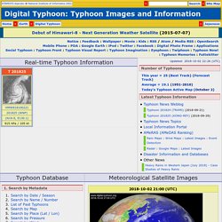
EOSDIS Worldview. IRIS Earthquake Browser. Digital Typhoon: Typhoon Images and Information - National Institute of Informatics. This site has the comprehensive archive of meteorological satellite "Himawari" images since 1978, and offers a typhoon database of about 200,000 typhoon images since 1979 and typhoon best tracks since 1951 to search by date, name, location, cloud patterns, and so on.
Recently this site started to provide typhoon forecast information, but the latest typhoon information, weather forecast, advisories and warnings should be obtained from reliable sources such as "Japan Meteorological Agency: Typhoon Information" and other sites. Updates may be delayed due to the status of network between data sources. Images of past typhoons from 1979 to this year are archived.
In the informatics community, there is a growing interest in discovering relevant information from the huge amount of data that is overwhelming even in our everyday life. The canonical URL of this Web site is but is also accessible for the moment.