
Till Nagel – TileMill for Processing. This tutorial describes how to create beautiful custom maps, and use them in a Processing sketch.
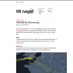
We are going to use TileMill to style our maps, export it, and load the rendered map tiles into PImages. There are two ways of doing that. Basic A single image as static map. If you simply need a geographical background, or want to put some data onto a fixed map, this is the easy way to go. See the example below. Advanced An interactive tile-based map, where users can zoom and pan. Custom map adapted to style of a visualization. Designing custom maps In the last years, there have been tremendous changes in the digital cartography field. Fortunately, in 2009 the CloudMade editor was launched, in which users can select various properties and style maps based on OpenStreetMap by themselves. Now, say hello to the new kid in town: TileMill – A map design studio TileMill is a map design environment, which – as they put it – “enable[s] artists to design maps”.
Single image as static map. Downloads. LizMap. I.
Passez à LizMap librement Notre solution LizMap, constituée du logiciel QGIS, de son plugin LizMap, et de l'application Internet associée LizMap Web Client, est disponible gratuitement au téléchargement. Vous n'avez aucune licence commerciale à contracter pour obtenir chacune des briques logicielles, elles sont librement exploitables. Le tableau ci-dessous indique les différents liens de téléchargement pour chaque élément Après avoir récupéré les 3 applications, vous devrez les installer et les configurer pour pouvoir utiliser LizMap. RelucBlog : Installer LizMap sous Windows II. Offre #1 / Nous hébergeons vos données et l'application sur nos serveurs Prestations d'hébergementPour adapter nos solutions à vos besoins, nous vous proposons 4 types d'hébergement : LizMap Découverte, Standard, Pro et Gold. Info Pour l'hébergement, le paiement se fait au lancement pour une durée minimum de 6 mois. Offre #2 / Nous intégrons votre identité à LizMap.
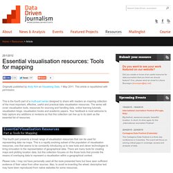
How To Build an Interactive Map with Open-Source Tools. My interactive migration map for Forbes, showing inbound (blue) and outbound (red) migration to and from Maricopa County, Arizona My latest interactive migration map on Forbes.com improves on the previous version in a few ways: it’s got five years of data instead of one; a brand-new layout; and some much-requested features like a search tool and the ability to switch off the lines.
TileMill. A la découverte de Tilemill. Introduction TileMill est un logiciel qui a pour but de produire des cartes qu'on puisse mettre à disposition facilement en ligne.

Pour cette raison, les cartes sont générées en projection "Web Mercator" (souvent associé au code EPSG 900913). Il s'appuie sur les avancées de Mapnik, le moteur de rendu cartographique utilisé par OpenStreetMap. Il emprunte une partie de sa logique à celle des graphistes web : le système pour personnaliser les styles des cartes s'approche des CSS alors que les styles lorsqu'on utilise des standards sont définis généralement avec le SLD. Le project se concentre clairement sur le rendu de cartes, les fonctionnalités permettent de l'analyse spatiale et de l'interrogation géographique basique.
Commençons par mettre en place le système d'exploitation pour cela (en supposant que vous êtes sous Windows) Installation de la machine virtuelle Installer Virtualbox Aller sur Récupérer la version "VirtualBox 4.0.8 for Windows hosts". Récupérer une image disque. Manuel de TileMill en français. TileMill est un outil pour les cartographes permettant de concevoir rapidement et facilement des cartes pour le Web en utilisant des données personnalisées.

Il est construit sur la base de la puissante librairie de rendu cartographique open-source Mapnik - la même que celle qu'OpenStreetMap et MapQuest utilisent pour faire certaines de leurs cartes. TileMill n'est pas destiné à être un outil de cartographie généraliste, il se concentre plutôt sur la rationalisation et la simplification d'un certain nombre de cas d'utilisation. Pour ceux qui viennent du milieu ou la cartographie ou des SIG, la plus grande provocation que fait TileMill est la projection finale - Les cartes TileMill sont en effet, toujours projetées en "Web Mercator. Comme son nom l'indique, cette projection est populaire avec les applications de cartographie web, et donc les cartes créées avec TileMill peuvent être affichées en utilisant l'API Google Maps, OpenLayers, et un certain nombre d'autres projets.
Les SIG GeoJSON. Data Driven Journalism. Originally published by Andy Kirk on Visualising Data, 1 May 2011.
This article is republished with permission. This is the fourth part of a multi-part series designed to share with readers an inspiring collection of the most important, effective, useful and practical data visualisation resources. The series will cover visualisation tools, resources for sourcing and handling data, online learning tutorials, visualisation blogs, visualisation books and academic papers. ScapeToad. Scribble Maps. Indiemapper. OpenGeo. ArcGIS. GeoCommons. BatchGeo. Polymaps. Quantum GIS. Portal. OpenStreetMap.
OpenStreetMap for Beginners.