
Earth. Untitled. FUMDHAM - Pinturas rupestres. O complexo estilístico Serra Talhada é muito mais heterogêneo e possui diversas características classificatórias que não estão sempre presentes em todos os sítios pertencentes à classe, mas quando uma falta outra está representada.
A classe se caracteriza pelas séries de figuras humanas dispostas em linha e a utilização de várias cores (vermelho, branco, cinza, marron, amarelo), sendo comuns as figuras bicromáticas ou tricromáticas. Aparecem também figuras com características gráficas muito peculiares, assim figuras humanas apresentam as extremidades exageradamente compridas; abundam também as figuras extremamente pequenas. File:Chauvethorses.jpg. File:Clovis Rummells Maske.jpg. File:SantaCruz-CuevaManos-P2210651b.jpg. Foto Il grande viaggio di Homo sapiens - 1 di 1. Frontiers of Anthropology: "Peking Man" Upper Cave and the Ethnic Variety of Lemurians, Part II.
At the famous "Peking Man" site of ZhouKouDian, China, there were fossil humans at two levels: the lower cave finds were the more famous Homo erectus pekinsis (originally "Sinanthropus")The importance of this site cannot be underestimated because of the unusually diverse ethnic types of the skulls found there: the Upper Cave people were apparantly both polygamous and cosmopolitan.
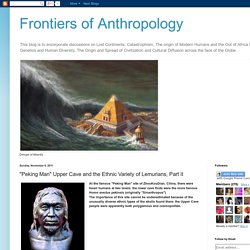
The above painting represents Chinese Upper Cave people and as such theyy are very much like the earliest European modern Homo sapiens and presumably like their Central-Asia common ancestors (we have no fossils of these but we can infer their presence from genetic evidence) Below on the other hand are the more typical Southern Asiatic Early Modern Homo sapiens as typical of the ancestors of the Australian Aboriginals.
These are descendants of another branch out of the same ancestors that diverged early on. The following map is an oriental expression of the same idea, continuing on to Global Superflood 3 12. Chegada do homem à América - Disciplina - História. File:Maler der Grabkammer des Menna 001.jpg. File:Néolithique 0001.jpg. File:Hache polie néolithique.jpg. Category:Neolithic artefacts. Category:Neolithic axes. File:Roman harvester, Trier.jpg. Online Extra @ National Geographic Magazine. NG Maps; Sources: Bruce D.
Smith, Dolores Piperno, Dorothy Pearsall, and International Food Policy Research Institute Farms Take Humans to the Future by Tom Cannell For the vast majority of their two million years on Earth, humans existed as hunter-gatherers—their greatest challenge to find food in the wild. Most were nomads, following their food as the seasons changed to be near available supplies of the plants and animals they ate. It was only 10,000 years ago that humans began to put their knowledge to more intensive use. No theory completely explains this transition to intensive agriculture. Humans changed the biology of the plants and animals on which they had always depended, but the dawn of agriculture in turn changed the lives of humans forever. At the time of the agricultural revolution there may have been close to ten million people alive. File:Centres of origin and spread of agriculture.svg. Ceres, Goddess Of Agriculture - Free Image on Pixabay - 33088.
File:Population curve.svg. Cancel Edit Delete Preview revert Text of the note (may include Wiki markup) Could not save your note (edit conflict or other problem).
Please copy the text in the edit box below and insert it manually by editing this page. Upon submitting the note will be published multi-licensed under the terms of the CC-BY-SA-3.0 license and of the GFDL, versions 1.2, 1.3, or any later version. See our terms of use for more details. Add a note Draw a rectangle onto the image above (press the left mouse button, then drag and release). Save To modify annotations, your browser needs to have the XMLHttpRequest object. File:World population growth (lin-log scale).png. File:Oscar Pereira da Silva - Desembarque de Pedro Álvares Cabral em Porto Seguro em 1500.jpg.
Conquista ou Descobrimento do Brasil? O Descobrimento do Brasil. Tela de Oscar Pereira da Silva (1865-1939), Desembarque de Pedro Álvares Cabral em Porto Seguro, em 1500.

A conquista da América sob o ponto de vista das populações nativas. I- A História das populações indígenas da América não começou em 1492 O objetivo desta primeira aula é chamar a atenção dos alunos para a diversidade de povos e culturas existentes na América antes da chegada dos europeus, no século XV.

Para tanto, sugerimos três atividades: 1- Teorias sobre a origem dos primeiros habitantes da "América" Esta primeira aula pode contribuir para que os alunos desconstruam a idéia de que a história do continente no qual vivemos iniciou-se apenas no século XV, com a conquista européia, uma vez que as pesquisas científicas indicam que a ocupação da "América" ocorreu muito antes da chegada dos europeus e, por todos os lados do continente, diferentes histórias foram construídas desde então. Explorando a temática a partir do trabalho com jornais, revistas, livros didáticos e internet: Cadernos questoes 6a serie. Untitled. Ghisp11. File:Colonisation2.gif. File:Poliodrops.jpg. Human Numbers Through Time. By Susan K.
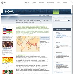
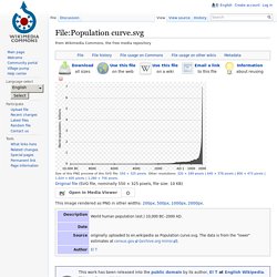
Lewis Posted 04.20.04 NOVA For most of human existence our ancestors led precarious lives as scavengers, hunters, and gatherers, and there were fewer than 10 million human beings on Earth at any one time. Today, many cities have more than 10 million inhabitants each, and populations continue to skyrocket. Trace the dramatic growth of human populations over recent centuries on our global map, and see where on Earth as many as three billion more people may live by 2050. Note on Graphics The global map was adapted from World Population: A Graphic Simulation of the History of Human Population Growth, a 2003 video produced by Population Connection (www.populationconnection.org).
When areas become super-populated, as they begin to do in certain parts of the world in the 20th century, the dots merge and spread outward like a stain. Human Numbers Through Time. Human Numbers Through Time. Human Numbers Through Time. Human Numbers Through Time. File:SchoolchildrenWashingHands.jpg. Human Numbers Through Time. Human Numbers Through Time. File:Kaiapos.jpeg. File:Plato's Academy mosaic from Pompeii.jpg. Indoeuropean. File:Human Language Families Map.PNG. File:SouthAmerican families.png.
UNESCO Atlas of the World's Languages in danger. UNESCO Interactive Atlas of the World’s Languages in Danger The online edition of the Atlas is complementary to the print edition It does not reproduce the regional and thematic chapters of the print version, but it offers additional information on the listed endangered languages. Via this interface, you can browse through them, using combinations of search criteria and/or zooming in the map below (see Browsing functionnalities ). For more detailed information, please consult the Languages mapping , Contribute your comments and FAQ pages. For remarks on a specific language, please use the in-built forms ('submit a comment' tab) of the Interactive Atlas.
If you wish to suggest an endangered language to be included in the Atlas, please fill in this form. For more general comments, please email atlas_AT_unesco.org. Search tools vulnerable. Encarte censo indigena 02%20B. Pdf brasil ind.