
Milestones: 1776–1783. In 1782, Benjamin Franklin rejected informal peace overtures from Great Britain for a settlement that would provide the thirteen states with some measure of autonomy within the British Empire.
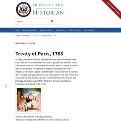
Franklin insisted on British recognition of American independence and refused to consider a peace separate from France, America’s staunch ally. Franklin did agree, however, to negotiations with the British for an end to the war. Joined by peace commissioners John Adams and John Jay, Franklin engaged the British in formal negotiations beginning on September 27, 1782. American Negotiations of the Peace of Paris Although Franklin demanded the cessation of Canada to an independent America, he knew that the British Government of Lord Shelburne, opposed to American independence, was unprepared to accept that offer. The illustration above, a copy of a sketch by the studio of Benjamin West, shows the American negotiators of the Peace of Paris. Born in Slavery : récits d'anciens esclaves. Born in Slavery: Slave Narratives from the Federal Writers’ Project, 1936-1938, voilà un projet à côté duquel il serait bien dommage de passer.
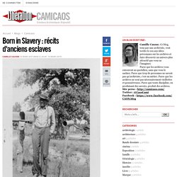
En 1936, en pleine dépression, le Federal Writers Project (FWP) envoie des écrivains dans 17 Etats Américains pour interviewer des gens ordinaires et écrire leurs histoires de vie. Les premiers Etats qui se lancent ciblent des anciens esclaves. Très intéressé par le matériel recueilli de ces Etats, John A. Lomax, conseiller national en folklore pour le FWP et conservateur des Archives de chants folkloriques américains à la Bibliothèque du Congrès, ordonne aux autres Etats impliqués dans le projet d’interroger également d’anciens esclaves. 'Battle Lines' Is A Civil-War Comic Hollywood Can Learn From. When people think of comics they typically think of bite-sized chunks, which is one of the reasons why the medium has long been viewed as unserious and juvenile.
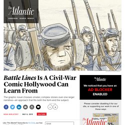
Neither the daily strip nor the monthly superhero story has enough heft to provide deep insights into life, the universe, or anything. It's no coincidence that the works that have won mainstream acceptance, like the initially serialized Maus and Watchmen, work as longform graphic novels that can hold their own on a bookshelf next to more weighty tomes like Moby Dick or Ulysses. Big themes and big stories, conventional wisdom goes, require big works. The Civil War is as vast a story as one can expect, but Battle Lines: A Graphic History of the Civil War doesn’t attempt to do justice to it by going big.
Instead, the writer and artist Jonathan Fetter-Vorm and the historian Ari Kelman organize their tale in a traditional way—as a series of separate strips punctuated with single text-pages providing historical background. Curtis (Edward S.) Collection - About this Collection - Prints & Photographs Online Catalog. Jacquin (Philippe) : Les Indiens blancs, Français et Indiens en Amérique du Nord (XVIe- XVIIIe siècle) JACQUIN (Philippe) : Les Indiens blancs, Français et Indiens en Amérique du Nord (XVIe- XVIIIe siècle). — Paris, Payot, 1987. — 24 cm, 310 p.
Cet ouvrage étudie du XVIe au XVIIIe siècle, mais essentiellement au XVIIe siècle, dans les territoires de la Nouvelle-France du Canada, parfois élargis vers la Louisiane, les Blancs, « truchements », puis coureurs des bois qui ont vécu plus ou moins longtemps au milieu des villages indiens, d'où le titre. Ce travail est l'aboutissement de longues recherches difficiles, car, des deux côtés, il s'agit de civilisations orales connues par des notations dans les archives ou par les relations des jésuites.
Notes et bibliographie permettent de mesurer le travail de Philippe Jacquin : la série Cil du fonds des colonies, les sources imprimées de l'époque, les travaux des auteurs français, canadiens et anglo-saxons qui se sont intéressés à ces problèmes. Interactive map: Loss of Indian land. The Vault is Slate's history blog.
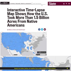
Like us on Facebook, follow us on Twitter @slatevault, and find us on Tumblr. Find out more about what this space is all about here. This interactive map, produced by University of Georgia historian Claudio Saunt to accompany his new book West of the Revolution: An Uncommon History of 1776, offers a time-lapse vision of the transfer of Indian land between 1776 and 1887.
As blue “Indian homelands” disappear, small red areas appear, indicating the establishment of reservations. (Above is a GIF of the map's time-lapse display; visit the map's page to play with its features.) The project’s source data is a set of maps produced in 1899 by the Bureau of American Ethnology. While the time-lapse function is the most visually impressive aspect of this interactive, the “source map” option (available on the map's site) offers a deep level of detail. This vagueness benefited the government’s purposes in crafting treaties and executive orders.